1951 Annand Pictorial Map of the Bahamas
Bahamas-annand-1951-2$500.00
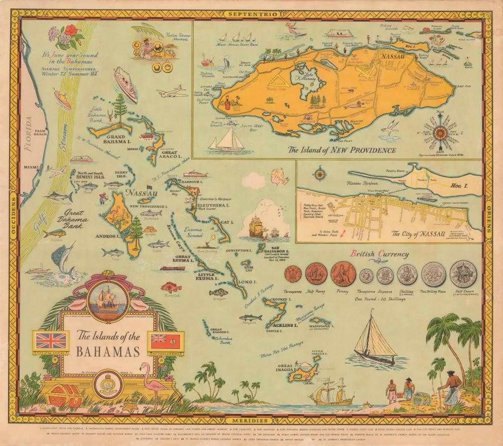

Title
The Islands of the Bahamas.
1951 (dated) 19 x 21.25 in (48.26 x 53.975 cm) 1 : 2375000
1951 (dated) 19 x 21.25 in (48.26 x 53.975 cm) 1 : 2375000
Description
A splendid and vibrant 1951 pictorial map of the Bahamas by George Annand. It highlights elements of the islands' history, economy, and leisure activities, with the likely intention of attracting tourists.
Two insets are included at top-right, one of the island of New Providence (home to some 70% of the islands' population) and the other of the city of Nassau. A key at bottom corresponds to numbers on the Nassau inset map, identifying key sites in the city such as government buildings, wharves, markets, and churches.
The title cartouche includes the coat of arms of the Bahamas, with the motto 'Expulsis Piratis – Restituta Commercia,' while an illustration at bottom-right refers to the history of abundant piracy in the area in the 17th and early 18th century. A note next to San Salvador Island mentions the first landing of Columbus in the New World there in October 1492.
This map was made in the latter days of direct British colonial rule. A parliament for the islands had been established in 1940, after which it achieved internal autonomy in 1964 and full independence in 1973.
Due to its strategic location, Nassau was the target of repeated attacks by foreign powers, especially the Spanish but also American colonists during the American Revolution. After the war, British loyalist refugees, including large numbers of African-descended slaves and freedmen along with some Native Americans, settled on the islands. After the British Empire outlawed the slave trade in 1807, freed Africans from intercepted slave ships were also settled in the Bahamas (where the practice of slavery was outlawed in 1834). Additional Black and Native American refugees from the United States escaped to the Bahamas throughout the early-mid 19th century.
Remaining a largely forgotten corner of the British Empire, the Bahamas have thrived in the postwar period, when the country developed an economy relying on tourism and offshore finance. The comment at top-left about the agreeable climate of the islands, the emphasis on fishing and beaches, and presumably the map as a whole, were produced with the goal of promoting tourism, especially from nearby Florida.
A Closer Look
This map takes in the entire archipelago forming the Bahamas, roughly concurrent with the Lucayan Archipelago, composed of over more than 3,000 island, islets, cays, and other features. It is rich with illustrations of different types of fish, ships, British currency, human figures, including pirates and bikini-clad beachgoers, and more.Two insets are included at top-right, one of the island of New Providence (home to some 70% of the islands' population) and the other of the city of Nassau. A key at bottom corresponds to numbers on the Nassau inset map, identifying key sites in the city such as government buildings, wharves, markets, and churches.
The title cartouche includes the coat of arms of the Bahamas, with the motto 'Expulsis Piratis – Restituta Commercia,' while an illustration at bottom-right refers to the history of abundant piracy in the area in the 17th and early 18th century. A note next to San Salvador Island mentions the first landing of Columbus in the New World there in October 1492.
This map was made in the latter days of direct British colonial rule. A parliament for the islands had been established in 1940, after which it achieved internal autonomy in 1964 and full independence in 1973.
From Pirate Haven to Tourist Heaven
The history of the Bahamas is closely tied to piracy. The Spanish had claimed the islands in the wake of Columbus' voyages, but showed little interest in them, allowing the English to establish a small number of settlers there. However, the islands became central to the 'Golden Age of Piracy' in the 17th and early 18th century, as they provided an excellent haven for pirates to strike passing ships and quickly disappear among the innumerable islands of the archipelago. By the early 1700s, Nassau had been declared a 'Pirate Republic' and more than 1,000 pirates had established themselves in the region. To remedy the situation, the British declared the Bahamas a crown colony in 1718 and cracked down on the privateers.Due to its strategic location, Nassau was the target of repeated attacks by foreign powers, especially the Spanish but also American colonists during the American Revolution. After the war, British loyalist refugees, including large numbers of African-descended slaves and freedmen along with some Native Americans, settled on the islands. After the British Empire outlawed the slave trade in 1807, freed Africans from intercepted slave ships were also settled in the Bahamas (where the practice of slavery was outlawed in 1834). Additional Black and Native American refugees from the United States escaped to the Bahamas throughout the early-mid 19th century.
Remaining a largely forgotten corner of the British Empire, the Bahamas have thrived in the postwar period, when the country developed an economy relying on tourism and offshore finance. The comment at top-left about the agreeable climate of the islands, the emphasis on fishing and beaches, and presumably the map as a whole, were produced with the goal of promoting tourism, especially from nearby Florida.
Publication History and Census
This map was drawn by George Annand and published in 1951 in Miami. It is only listed among the holdings of the University of Florida, the Miami Dade Public Library System, and the University of Illinois Urbana Champaign, and it is scarce to the market.Cartographer
George Annand (June 9, 1890 - September, 1980) was an American graphic artist and cartographer active in New York during the middle part of the 20th century. Annand was born in Croswell, Michigan, the sun of a Scottish immigrant doctor who immigrated to the United States via Canada. He received his early education at a one-room schoolhouse in Croswell before he and his parents relocated to Detroit. It was in Detroit that Annand was first introduced to the arts, enrolling in Art School. Later, as a young man, Annand move to New York City, where he continued his artistic studies at the Art Students League. In 1920 he married a childhood friend, Elizabeth Sinclair, who had been widowed during World War I. He adopted Elizabeth's two children and she and Annand shortly thereafter became pregnant with a third child. With a family to support and another 'bun in the oven' Annand turned to the booming New York advertising industry, taking work with the National Biscuit Company (NABISCO). He did well at NABISCO painting, as he liked to joke 'Fig Newtons in their native habitat.' He also took freelance work designing illustrated book covers. One of his first such jobs was illustrating a cover for C. E. Montague's Right off the Map. Naturally, given the nature of the work, the cover featured a map incorporating pictorial elements with aspects of baroque era cartography - Annand's first pictorial map. The Wall Street Crash of 1929 hit Annand's interests hard and he lost his job a Nabisco. Refusing WPA work for reasons of personal pride, Annand managed to get by on odd illustration contracts for various companies including publishers like Doubleday, Doran, and Charles Scribner, as well as pictorial map work for the Waldorf Astoria Hotel, General Foods, Sinclair Oil, and more. His cartographic work eventually drew the attention of the Chicago based map publishing giant Rand McNally, who commissioned him to produce two of their popular 'Romance Maps.' During and after World War II business began to pick up again and Annand produced a huge corpus of pictorial maps. His style combined decorative elements from 16th century Dutch decorative cartography, fine calligraphy, and more contemporary pictorial work. He wanted his maps are noteworthy for their clarity and the sense of space they convey. Annand was, according to Stephen Horsby in Picturing America: The Golden Age of Pictorial Maps, 'a cartographer's cartographer.' Annand continued to produce pictorial maps until forced to sop due to cataract surgery in 1970. He died 10 years later in 1980, at 90 years old. More by this mapmaker...
Condition
Very good. Small tear on left border professionally repaired.
References
Rumsey 8230.000. OCLC 48672990.