This item has been sold, but you can get on the Waitlist to be notified if another example becomes available.
1941 Nazi German Army Group North Atlas of First Months of Operation Barbarossa
BarbarossaAtlas-hermann-1941$4,750.00


Title
Der Feldzug gegen die Sowiet-Union / Kriegsjahr 1941 / Bearbeitet in der Führungsabteilung des Oberkommandos der Heeresgruppe Nord.
1941 (dated) 12 x 17.5 in (30.48 x 44.45 cm)
1941 (dated) 12 x 17.5 in (30.48 x 44.45 cm)
Description
A proof-state white-kid-bound 1941 World War II German general's presentation atlas, here in its only known example, chronicling the first 6 months of Operation Barbarossa. It was lavishly published on Christmas Eve 1941 by the General Staff of Army Group North as a gift to members of Army Group North's General Staff participating in the invasion. This atlas appeared at a high point in the Nazi campaign to conquer the Soviet Union, and the bravado that accompanied their early successes is evident. The present example, 'proof no. 2', is the only known surviving copy.
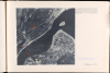
Army Group North continued to make fantastic gains, capturing Pskov, Russia (which became the Army Group's headquarters and where this atlas was published), Tallinn, Estonia, on August 28, and Novgorod, Russia, on September 9. Army Group North had reached the southern outskirts of Leningrad by early September 1941, and the Finns (the Nazi's allies) occupied the land to the north of the city. Hitler planned to raze the city completely and either kill or expel its 2.5 million residents and annex all the territory south of the Neva River. The Finns would gain all the territory north of the Neva. Hitler was so confident that victory was near that invitations to a victory party at Leningrad's luxurious Astor Hotel were printed.
A Closer Look
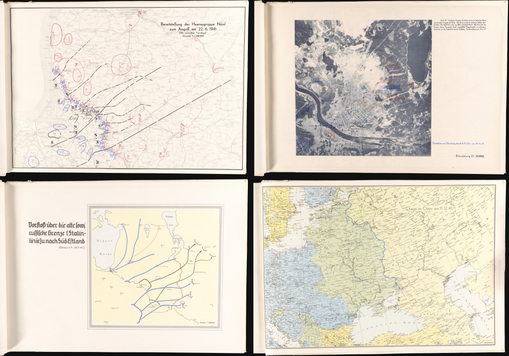
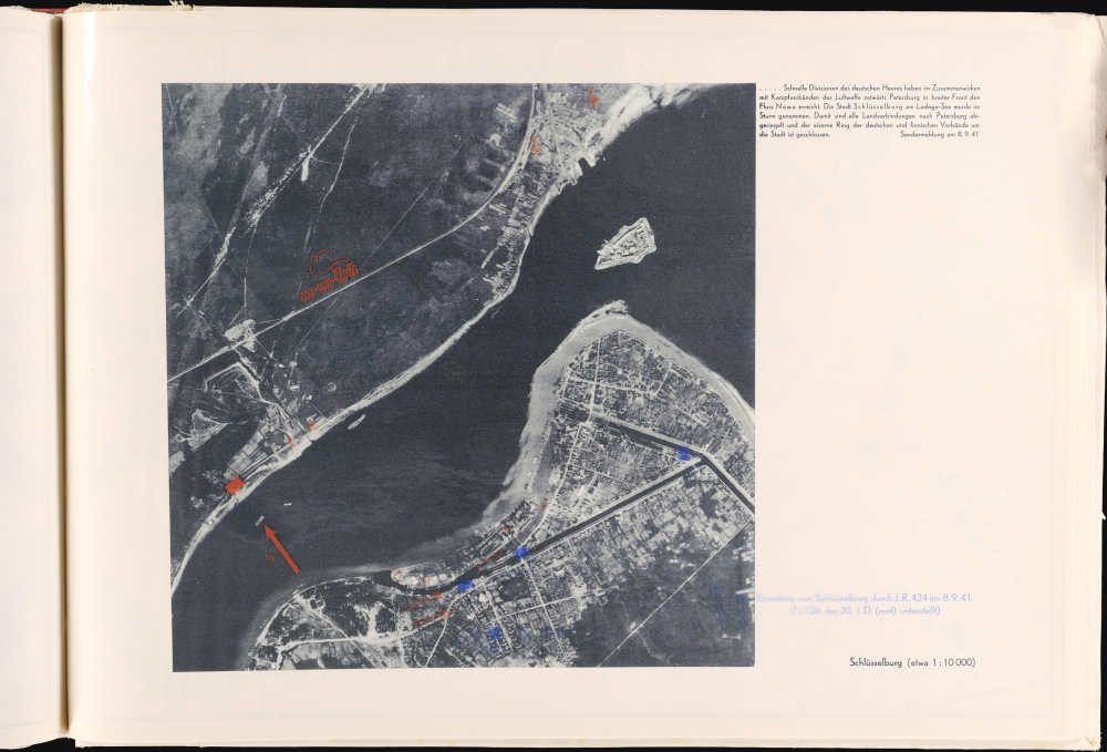
The atlas's editor, Lt. Colonel Paul Reinhold Herrmann, and the General Staff of the Heeresgruppe Nord (Army Group North) paid special attention to its production. It is technically extraordinary work with over 100 custom-made maps, some with transparent overlays, as well as aerial photographs. These maps track with granular detail the progress of Army Group North through the Baltic states (Estonia, Latvia, and Lithuania) towards Leningrad. In addition to the more conventional maps, some feature transparent plastic overlays. A few are aerial photographs, a handful of which also feature the transparency overlays.The first few maps, in a section titled 'Der Aufmarch' [The March], illustrate the Group's preparations for Operation Barbarossa. The next section, titled 'Der Feldzug' [The Campaign], forms the bulk of the work. Maps chronicle daily progress from June 22, 1941 (the date Operation Barbarossa launched) through July 31, 1941, and a few days in August. After that, the maps cover a few days in September and October, likely only showing the major changes to the siege around Leningrad. The final section comprises a group of 'situation' maps that illustrate broader periods of time and actions. The last map in the atlas illustrates the Eastern Front as it was on December 11, 1941.This Example in Focus
Even though this is the only known surviving example of the atlas, there almost certainly were more printed. The present example is marked 'Prüf[ung] nr. 2' or 'Proof No. 2' in manuscript on the inside front cover, meaning that it was the second proof state of the atlas. The fact that it is a proof explains why the present example is not inscribed to a specific officer. This example also features a beautiful manuscript half-title page signed by the atlas's editor, Oberstleutnant Paul Reinhold Herrmann (1898-1980).Operation Barbarossa and Army Group North
The Army Group North (Heeresgruppe Nord) was created to invade the northern sector of the territory occupied by the Soviet Union during Operation Barbarossa. Launched on June 22, 1941, Army Group North was responsible for capturing Estonia, Latvia, and Lithuania and then proceeding into northwestern Russia. It included the 16th and 18th Armies, the 4th Panzer (Tank) Division, and the Luftwaffe's 1st Air Fleet. Army Group North launched its attack from German Königsberg and made rapid progress, conquering virtually all of Latvia and Lithuania in the first 3 weeks. Nazi Germany declared the creation of Reichskommissariat Ostland on July 17, 1941, which was meant to govern all of the Baltic territories and the adjacent lands and under which the Nazis could implement their regime of oppression and genocide.Army Group North continued to make fantastic gains, capturing Pskov, Russia (which became the Army Group's headquarters and where this atlas was published), Tallinn, Estonia, on August 28, and Novgorod, Russia, on September 9. Army Group North had reached the southern outskirts of Leningrad by early September 1941, and the Finns (the Nazi's allies) occupied the land to the north of the city. Hitler planned to raze the city completely and either kill or expel its 2.5 million residents and annex all the territory south of the Neva River. The Finns would gain all the territory north of the Neva. Hitler was so confident that victory was near that invitations to a victory party at Leningrad's luxurious Astor Hotel were printed.
Not the Victory They Envisioned
Almost 84 years after the beginning of what became known as the Siege of Leningrad (September 8, 1941 - January 27, 1944), we know that the laudatory and celebratory tone the atlas exudes did not last. The Soviet Red Army stopped the Nazis before they reached Moscow, and by January 1942, the Red Army began pushing the Nazis back. After 3 years of fighting and millions of lives, the Red Army pushed the invading Germans all the way back to Berlin.Publication History and Census
This atlas was created by and for the High Command of Army Group North under the direction of Lt. Colonel Paul Reinhold Herrmann. It was published in Pskov, Russia, at the headquarters of Army Group North on December 24, 1941, by the Druckereizug der Vermessungs- und Karten- Abteilung (Motorisiert) 624 [Printing Company of the 624th Motorized Surveying and Map Detachment.] Numerous specialized units, such as the 624th Motorized Surveying and Map Detachment, were part of the Nazi German Army. These units consisted of skilled surveyors, draftsmen, and printing technicians and usually traveled in specially equipped train cars that included drafting/photography studios and advanced printing presses. At other times, these units were based at specific locations in Nazi-controlled territory. At the time of this atlas's production, the 624th Motorized was based at the headquarters of Army Group North in Pskov. As stated above, this is the only known surviving example.Cartographer
Paul Reinhold Herrmann (April 22, 1898 - September 14, 1980) was a German military officer. Born in Mönchengladbach, Herrmann joined the 2nd Thuringian Infantry Regiment No. 32 of the German Army at age 16 in 1916 after graduating from high school and served as a lieutenant during World War I. He remained in the army after World War I and attended military academies in Münster and Berlin. Between 1921 and 1939, he was promoted several times and was serving as a lieutenant colonel on the General Staff of the 44th Infantry Division when World War II began. He was a member of the General Staff of the 16th Army, which was part of Army Group North, during Operation Barbarossa in 1941 and 1942. He was named the commanding officer of the 264th Infantry Division as a major general in September or October 1944. Hermann was a British prisoner of war from May 1945 until July 1947. After being released by the British, he was unemployed for some time before he became a military expert for the German defense at the Nuremberg Trials from February to December 1948. After Nuremberg, he worked for Rudolf Majert GmbH in Kassel as a field employee and then as an authorized signatory until May 1956. He was activated as a major general in the Bundeswehr (the armed forces of the Federal Republic of Germany, commonly known as West Germany) in 1956 and retired from the Bundeswehr on October 1, 1961. He worked as a 'permanent advisor on matters of civil protection' with the Bundeswehr after his retirement. More by this mapmaker...
Condition
Excellent. Oblong folio. 127 pp. with title page in manuscript but the rest photolithographed. Handbound in original white kid, handlaced in red kid. Fitted into original slipcase.