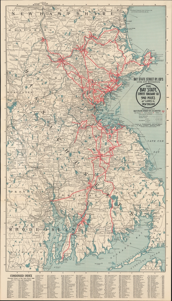
1917 Bay State Street Railway Map of New England, Interurban Trolley Lines
BayStateStreetRy-passengerdept-1917$350.00


Title
Bay State Street Ry. Co's lines and connections. / The Bay State Street Railway Co. 940 Miles of Lines in New England.
1917 (undated) 26 x 14.75 in (66.04 x 37.465 cm) 1 : 300000
1917 (undated) 26 x 14.75 in (66.04 x 37.465 cm) 1 : 300000
Description
This is a c. 1917 map of the Bay State Street Railway system in New England. The map marks the final days of interurban street railways in New England.
A Closer Look
This colorful map covers from southern New Hampshire in the north to Rhode Island and Martha's Vineyard in the south. The lines of the Bay State Street Railway are traced in thick red lines, with the railway's power stations and car houses noted with red dots. Other electric lines, steam railroads, steamship lines, administrative boundaries, and parks are recorded as indicated in the legend below the title. Additional features, such as cities and towns, waterways, lighthouses, mountains, and islands, are also identified. Concentric circles are drawn at ten-mile intervals from downtown Boston. The map is surrounded by a grid corresponding to an index at the bottom, listing principal points on the railway's route.Bay State Street Railway
The Bay State Street Railway was formed in 1911 by the merger of the Boston and Northern Street Railway, which, as its name implies, operated out of Boston to destinations to the north, and the Old Colony Street Railway, which connected the city with points south. Both the Boston and Northern and the Old Colony had themselves already gone through multiple mergers and consolidations, leaving the Bay State Street Railway with the extensive network seen here, one of the largest such networks in the country, operating as far north as Nashua, New Hampshire and Newburyport, Massachusetts, and as far south as New Bedford, Massachusetts, and Providence and Newport, Rhode Island. The Bay State ran both urban/suburban local service and longer-distance interurban service on electrified lines. Like its predecessors, it faced financial difficulties on several fronts, went into receivership in late 1917, and was reborn as a key part of the Eastern Massachusetts Street Railway, which survived until 1968 (by operating bus routes instead of streetcars) until being absorbed by the Massachusetts Bay Transportation Authority (MBTA).Interurban Streetcars
At the end of the 19th century, New England was serviced by an extensive network of interurban electric and steam-powered streetcars, the earliest of which often replaced horsecar lines. These were not proper railroads, but rather a separate system of electrified interurban streetcars (akin to the Pacific Electric System in Southern California), run by various competing companies, that extended from New York to Boston and throughout New England as far north as Bath and Lewiston, Maine. As mentioned above, these companies were consolidated in rapid succession in the early 20th century, with just a few left standing by 1920. The rise of the automobile, including buses operated by the streetcar companies, ushered in the end of interurban streetcar travel by 1940.Publication History and Census
This map was prepared by the Passenger Department of the Bay State Street Railway. It is undated, but as the company only existed between 1911 and 1917, it must date to that period. The map is quite rare; the Leventhal Map Center at the Boston Public Library holds an uncolored example, while the Connecticut State Library, University of Chicago (misdated c. 1939), and the non-profit organization Historic New England also note examples (either the present map or the uncolored variant) among their collections.Condition
Good. Reinforced where previously attached to binder. Verso repairs to fold separations and at fold intersections.
References
OCLC 56819377, 54383833. Leventhal Map Center G3764.B6P3 1917 .B39. Historic New England Ephemera Collection EP001.01.117.01.02.023.