This item has been sold, but you can get on the Waitlist to be notified if another example becomes available, or purchase a digital scan.
1859 Woodford Wall Map of Belknap County, New Hampshire: Lake Winnipesaukee
BelknapCounty-woodford-1859$1,875.00

Title
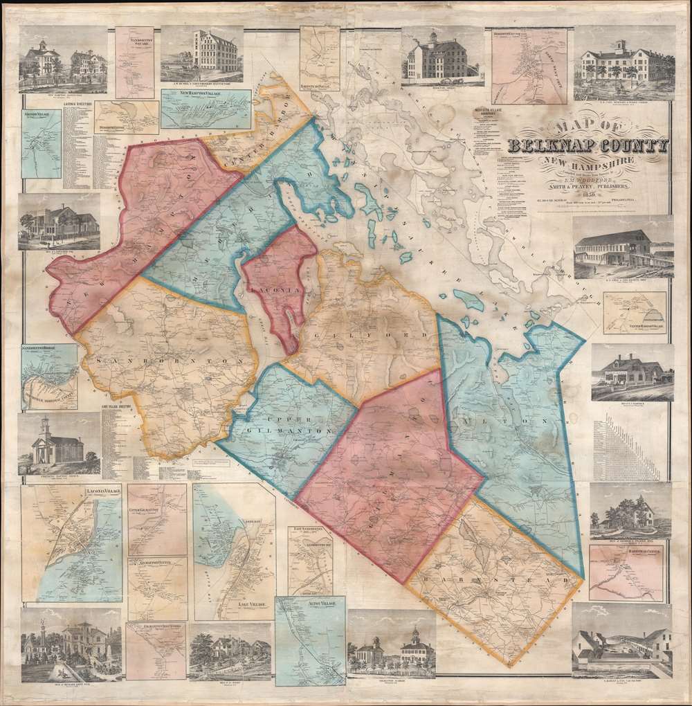
Map of Belknap County New Hampshire.
1859 (dated) 55.5 x 54.5 in (140.97 x 138.43 cm) 1 : 38400
1859 (dated) 55.5 x 54.5 in (140.97 x 138.43 cm) 1 : 38400
Description
A striking 1859 E. M. Woodford wall map of Belknap County, New Hampshire, embracing Lake Winnipesaukee and the southern tier of the White Mountains - for a generation the largest and most detailed map of this region. Coverage includes all of Lake Winnipesaukee and Belknap County to the southwest. Shading divides the county into constituent townships, with roads, placenames, and topography rendered in hachure. There are 16 inset detail maps, focusing on important communities, and 13 vignette views of prominent homesteads and businesses. In addition to its size and detail, this is most significant for naming thousands of landowners and residents, as well as important businesses, thus offering a unique record of Belknap in the mid-19th century.
Publication History and Census
This map was issued in 1859 by Edgar Maurice Woodford, partnered with the Philadelphia-based publishers Smith and Peavey. There are two editions of this map, published in 1859 and 1860. The present example corresponds to the 1859 first edition. Examples are scarce. In the OCLC we note just 2 holdings at the Library of Congress and a third at the New York Public Library. Additionally, there is an example at the New Hampshire Historical Society. Rare to the market.Cartographer
Edgar Maurice Woodford (April 15, 1824 – October 1, 1862) was a mid-19th century American abolitionist, civil engineer, surveyor, and map publisher active in New England. Woodford was born on his family farm in Avon, Connecticut. Although self-taught as a surveyor, he rose to become the official Hartford County surveyor. He was described by a nephew as 'a great strapping man,' who would come 'over the hills with his [surveying] instruments over his shoulder, crying for fear his work would not come out right.' Woodford produced numerous county surveys in Connecticut, Maine, and Massachusetts. Typically Woodford worked with other cartographers, but from time to time, he published independently, including his maps of Belfast and Frankfort, Maine, as well as Belknap, New Hampshire. As an abolitionist Woodford was part of the 1856 'Connecticut Colony in Kansas,' an attempt to colonize Kansas with enough abolitionist New Englanders to sway the vote and force Kansas to enter the Union as a Free State. When the Civil War broke out he enlisted in the Seventh Connecticut Volunteer Infantry, where he was assigned the rank of Quartermaster. It was during the war when he passed away in Hilton Head Island, South Carolina, of 'congestive fever,' an archaic term for malaria. He is interred in the soldiers cemetery at Hilton Head. More by this mapmaker...
Condition
Very good. Full professional restoration. Minor staining near title at top margin. The map is detached form rollers, but we will ship with rollers on request.
References
Library of Congress, G3743.B4 1859 .W6, G3743.B4 1859 .W6. New York Public Library, Map Div. 91-2979. New Hampshire Historical Society, 912.778a B432w. Cobb, D., New Hampshire Maps to 1900: An Annotated Checklist, #255. Stephenson, Land Ownership Maps, #423.