Digital Image: 1917 Rice Map of a Section of the Border Between the United States and Mexico
BorderPatrols-rice-1917_d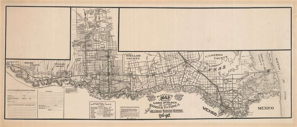

Title
Map Showing Lines of March and Border Patrols, In My Mexican Border Service. 1916 - 1917.
1917 (undated) 16 x 38.5 in (40.64 x 97.79 cm) 1 : 190000
1917 (undated) 16 x 38.5 in (40.64 x 97.79 cm) 1 : 190000
Description
FOR THE ORIGINAL ANTIQUE MAP, WITH HISTORICAL ANALYSIS, CLICK HERE.
Digital Map Information
Geographicus maintains an archive of high-resolution rare map scans. We scan our maps at 300 DPI or higher, with newer images being 600 DPI, (either TIFF or JPEG, depending on when the scan was done) which is most cases in suitable for enlargement and printing.
Delivery
Once you purchase our digital scan service, you will receive a download link via email - usually within seconds. Digital orders are delivered as ZIP files, an industry standard file compression protocol that any computer should be able to unpack. Some of our files are very large, and can take some time to download. Most files are saved into your computer's 'Downloads' folder. All delivery is electronic. No physical product is shipped.
Credit and Scope of Use
You can use your digial image any way you want! Our digital images are unrestricted by copyright and can be used, modified, and published freely. The textual description that accompanies the original antique map is not included in the sale of digital images and remains protected by copyright. That said, we put significant care and effort into scanning and editing these maps, and we’d appreciate a credit when possible. Should you wish to credit us, please use the following credit line:
Courtesy of Geographicus Rare Antique Maps (https://www.geographicus.com).
How Large Can I Print?
In general, at 300 DPI, you should at least be able to double the size of the actual image, more so with our 600 DPI images. So, if the original was 10 x 12 inches, you can print at 20 x 24 inches, without quality loss. If your display requirements can accommodate some loss in image quality, you can make it even larger. That being said, no quality of scan will allow you to blow up at 10 x 12 inch map to wall size without significant quality loss. For more information, it is best consult a printer or reprographics specialist.
Refunds
If the high resolution image you ordered is unavailable, we will fully refund your purchase. Otherwise, digital images scans are a service, not a tangible product, and cannot be returned or refunded once the download link is used.
Cartographer
Charles A. Rice (November 6, 1885 - August 12, 1931) was an American civil engineer. Born in Buffalo, New York, Rice was a member of the New York National Guard with the rank of sergeant during its deployment to the Mexican border in 1916-17. While there he created a map that others could use to trace their own movements around the area. Per a short article that appeared in The Buffalo Times on August 12, 1917, we learned that Rice served in the 74th Infantry Regiment for a year, before which he was an engineer in the State Highway Department. He obtained an honorable discharge after his year in the New York National Guard and found work in an irrigation engineering company. He was arrested in McAllen, Texas, where the regiment had been stationed, on suspicion of violating the Espionage Act, although we have found no trace of what happened with this charges. Rice stayed in McAllen, eventually becoming the City Engineer, a post he held for only six months before his death. He died on August 12, 1931 from a pulmonary embolism while living in McAllen, Texas. At the time of his death he was married to Virginia Rice, who appears to have been his second wife. His first wife, whom he married in 1907, was named Mary Octavia Rice. More by this mapmaker...
References
OCLC 42678909.