Digital Image: 1948 Harty Map of New England Ski Resorts
BostonGlobeSkiMap-harty-1948_d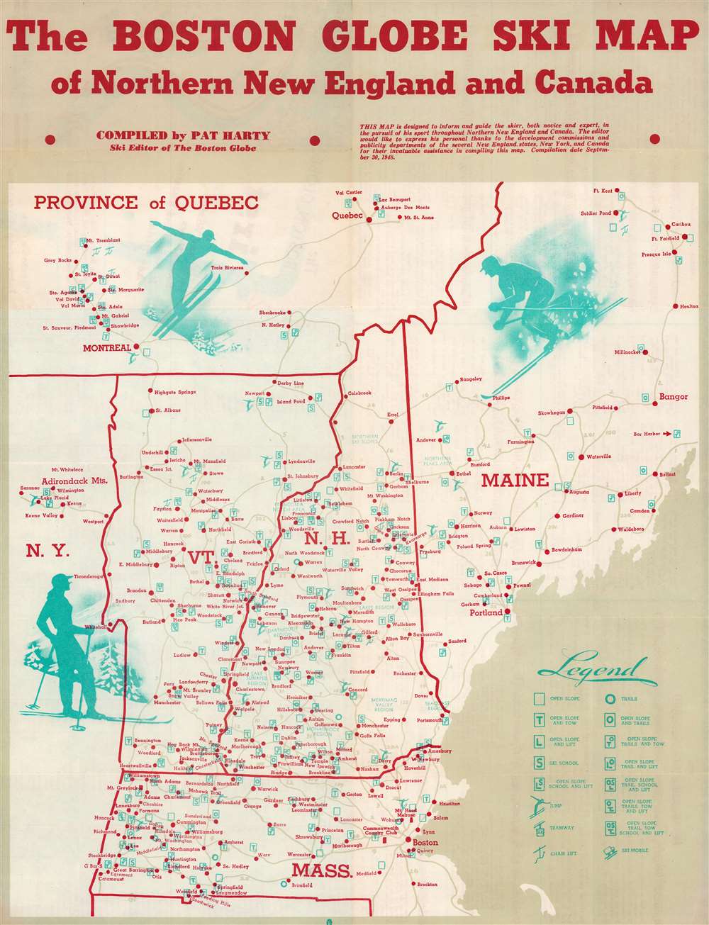

Title
Boston Globe Ski Map of Northern New England and Canada.
1948 (dated) 21.25 x 16.5 in (53.975 x 41.91 cm) 1 : 1000000
1948 (dated) 21.25 x 16.5 in (53.975 x 41.91 cm) 1 : 1000000
Description
FOR THE ORIGINAL ANTIQUE MAP, WITH HISTORICAL ANALYSIS, CLICK HERE.
Digital Map Information
Geographicus maintains an archive of high-resolution rare map scans. We scan our maps at 300 DPI or higher, with newer images being 600 DPI, (either TIFF or JPEG, depending on when the scan was done) which is most cases in suitable for enlargement and printing.
Delivery
Once you purchase our digital scan service, you will receive a download link via email - usually within seconds. Digital orders are delivered as ZIP files, an industry standard file compression protocol that any computer should be able to unpack. Some of our files are very large, and can take some time to download. Most files are saved into your computer's 'Downloads' folder. All delivery is electronic. No physical product is shipped.
Credit and Scope of Use
You can use your digial image any way you want! Our digital images are unrestricted by copyright and can be used, modified, and published freely. The textual description that accompanies the original antique map is not included in the sale of digital images and remains protected by copyright. That said, we put significant care and effort into scanning and editing these maps, and we’d appreciate a credit when possible. Should you wish to credit us, please use the following credit line:
Courtesy of Geographicus Rare Antique Maps (https://www.geographicus.com).
How Large Can I Print?
In general, at 300 DPI, you should at least be able to double the size of the actual image, more so with our 600 DPI images. So, if the original was 10 x 12 inches, you can print at 20 x 24 inches, without quality loss. If your display requirements can accommodate some loss in image quality, you can make it even larger. That being said, no quality of scan will allow you to blow up at 10 x 12 inch map to wall size without significant quality loss. For more information, it is best consult a printer or reprographics specialist.
Refunds
If the high resolution image you ordered is unavailable, we will fully refund your purchase. Otherwise, digital images scans are a service, not a tangible product, and cannot be returned or refunded once the download link is used.
Cartographer
John Patrick 'Pat' Harty (April 30, 1901 - February 25, 1959) was an American outdoor sportswriter and outdoor sports enthusiast. He was an avid amateur fisherman, skier, and hunter, who had earned a reputation as an authority in these fields. He worked as the Boston Globe outdoor sportswriter for fourteen years. Born in Saxtons River, Vermont, Harty attended Bellows Falls High School and St. Michael's College in Winooski. Before entering the newspaper field, Harty worked in Danvers, Massachusetts as a sales manager and salesman for a sporting goods firm. He joined the staff of the Newburyport News during the Great Depression, where he wrote about sports and sold advertising. Harty joined the Boston Globe sports staff in November 1945. More by this mapmaker...