Digital Image: 1857 J. W. Hill View of Boston Harbor (proof state)
BostonHarborView2-hill-1857_d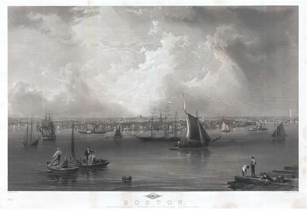

Title
Boston.
1857 (dated) 27 x 39 in (68.58 x 99.06 cm)
1857 (dated) 27 x 39 in (68.58 x 99.06 cm)
Description
FOR THE ORIGINAL ANTIQUE MAP, WITH HISTORICAL ANALYSIS, CLICK HERE.
Digital Map Information
Geographicus maintains an archive of high-resolution rare map scans. We scan our maps at 300 DPI or higher, with newer images being 600 DPI, (either TIFF or JPEG, depending on when the scan was done) which is most cases in suitable for enlargement and printing.
Delivery
Once you purchase our digital scan service, you will receive a download link via email - usually within seconds. Digital orders are delivered as ZIP files, an industry standard file compression protocol that any computer should be able to unpack. Some of our files are very large, and can take some time to download. Most files are saved into your computer's 'Downloads' folder. All delivery is electronic. No physical product is shipped.
Credit and Scope of Use
You can use your digial image any way you want! Our digital images are unrestricted by copyright and can be used, modified, and published freely. The textual description that accompanies the original antique map is not included in the sale of digital images and remains protected by copyright. That said, we put significant care and effort into scanning and editing these maps, and we’d appreciate a credit when possible. Should you wish to credit us, please use the following credit line:
Courtesy of Geographicus Rare Antique Maps (https://www.geographicus.com).
How Large Can I Print?
In general, at 300 DPI, you should at least be able to double the size of the actual image, more so with our 600 DPI images. So, if the original was 10 x 12 inches, you can print at 20 x 24 inches, without quality loss. If your display requirements can accommodate some loss in image quality, you can make it even larger. That being said, no quality of scan will allow you to blow up at 10 x 12 inch map to wall size without significant quality loss. For more information, it is best consult a printer or reprographics specialist.
Refunds
If the high resolution image you ordered is unavailable, we will fully refund your purchase. Otherwise, digital images scans are a service, not a tangible product, and cannot be returned or refunded once the download link is used.
Cartographer S
Benjamin Franklin Smith (1830 – 1927) was an artist, printer, and publisher of American city views active in the mid to late 19th century. Smith was born in South Freedom, Maine where he grew up on the family farm. His work is most commonly associated with his brothers, all of whom worked in the view-making industry, publishing both individually and separately as Smith Brothers. His brothers were Francis Smith, George Warren Smith, and David Clifford Smith. Among the brothers Benjamin, the youngest, was the most artistic, producing views as early as 1846, when he was 16. He drew his first city view, Albany as seen from the Hudson, at 17. Benjamin and his brothers initially worked as sales agents for viewmaker Edwin Whitefield. In 1849, the Smiths broke with Whitefield and began publishing under their own imprint, Smith Brothers. Benjamin Franklin drew at least four of the Smith Brother's views, and possibly significantly more. Reps suggests that the firm stopped publishing in 1855, but at least two important views, the 1857 Smith-Hill-Mottram view of Boston and the 1862 Smith view of Elmira, were issued later. Although both bear the Smith Brothers imprint, they were copyrighted by Benjamin Franklin Smith and are more likely than not, unassociated with the other brothers and their earlier views. In any case, the Smith firm was sold at an enormous profit in 1855, making the family extremely wealthy. They furthered their fortunes by investing in railroads. At the time of his death in 1927, Benjamin Franklin Smith was believed to be the richest man in Maine. More by this mapmaker...
John William Hill (January 13, 1812 – September 24, 1879) is a British-American landscape, still life, and view artist based primarily in New York City. Hill born in London, the son of aquatint engraver, John Hill. His family emigrated to the United States, settling in Philadelphian, in 1819. In 1822, they relocated to New York and opened an aquatint shop, at which J.W. Hill began an apprenticeship. In his early twenties, Hill began work for the New York State Geological Survey, producing topographic studies and overhead views of American cities and towns. There he developed a flair for rendering minute architectural detail and creating highly accurate perspectives. By the 1850s Hill embraced Pre-Raphaelite panting styles and represented that school in the United States. He was a founding member of the Society for the Advancement of Truth in Art. Learn More...
Charles Mottram (1807 - August 30, 1876) was an English steel plate, aquatint, and mezzotint engraver active in the 19th century. His work includes a vast corpus of views and illustrations ranging from engraved issues of famous paintings to unique city views. Mottram's work is admired application to steel plates of "sky tints" with the use of a ruling machine. Many of Mottram's plates enjoyed enduring popularity and were reissued well beyond his death into the 20th century. Learn More...
References
OCLC 191909096.