1850 Lincoln / Bufford Unrealized Plan of the Boston Public Garden
BostonPublicGarden-bufford-1850$2,500.00


Title
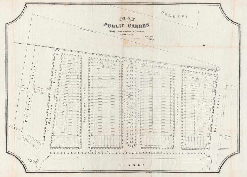
Plan of Public Garden : showing proposed arrangement of lots thereon.
1850 (undated) 28 x 38.5 in (71.12 x 97.79 cm) 1 : 600
1850 (undated) 28 x 38.5 in (71.12 x 97.79 cm) 1 : 600
Description
A curious and impressive large-scale work for the proud Bostonian, this is Ezra Lincoln's unrealized 1850 plan for the Boston Public Garden, published by John Henry Bufford. Part of a wider effort to develop the newly filled in 'Neck Lands' connecting Boston to Roxbury, Lincoln's plan was held up by long-standing and incessant disputes which were finally resolved in the late 1850s.
In the late 18th century, the site of the Public Garden was used as a ropewalk after a 1794 fire destroyed many existing ropewalks in the city. Afterwards, land was filled in using gravel removed from Mount Vernon and it significantly increased in value. The ropemakers planned to sell the land off for development, but faced strong public opposition. In 1824, the city purchased land back from the ropemakers and finally, in 1837, the Public Garden was established. However, legal disputes (not resolved until 1856) over the character and use of the land continued, hampering any plans for its use. Some in the city government still wanted to develop the land as housing, while others believed it to be public land that ought to be improved as a proper park.
As a result of these debates, initially much of the Public Garden was open grassland, like the Common, rather than a garden in the sense of a cultivated, planned landscape. This changed once the legal disputes were resolved, and in 1859 the Committee on the Common and Public Squares approved a new plan that included planned walkways, a pond, and an iron fence perimeter, closely resembling the Public Garden as it remains today.
A Closer Look
Oriented towards the west-southwest, Lincoln's plan proposed the separation of the land into lots and streets around a central parkway 75 feet wide. Such real estate would surely have commanded a premium, and fit within wider schemes to develop reclaimed land in and around the Back Bay into housing for the city's affluent. But Lincoln's plan was not to be; after intense and prolonged debate (see below), the Joint Committee on Public Lands, in the same report which contained the map, determined that the land could not be sold without the approval of the city's voters. The voters rejected the proposal and the land was conclusively set aside as a Public Garden.Unstable Land
The history of the Public Garden is closely connected with that of Boston Common, though the question of whether it was of the same character as the Common or whether the land on the southern end of the Common that became the Public Garden could be sold was debated for decades prior to the creation of this map. The Public Garden is also similar to the neighboring Back Bay in that much of it was previously mudflats which were filled in during the late 18th and 19th centuries.In the late 18th century, the site of the Public Garden was used as a ropewalk after a 1794 fire destroyed many existing ropewalks in the city. Afterwards, land was filled in using gravel removed from Mount Vernon and it significantly increased in value. The ropemakers planned to sell the land off for development, but faced strong public opposition. In 1824, the city purchased land back from the ropemakers and finally, in 1837, the Public Garden was established. However, legal disputes (not resolved until 1856) over the character and use of the land continued, hampering any plans for its use. Some in the city government still wanted to develop the land as housing, while others believed it to be public land that ought to be improved as a proper park.
As a result of these debates, initially much of the Public Garden was open grassland, like the Common, rather than a garden in the sense of a cultivated, planned landscape. This changed once the legal disputes were resolved, and in 1859 the Committee on the Common and Public Squares approved a new plan that included planned walkways, a pond, and an iron fence perimeter, closely resembling the Public Garden as it remains today.
Publication History and Census
This plan was drawn by civil engineer Ezra Lincoln and published in 1850 by John Henry Bufford for the Report of the Joint Committee on Public Lands in relation to the Public Garden, July, 1850. It is independently cataloged among the holdings of the Boston Public Library, the Boston Athenaeum, the Wisconsin Historical Society, the New York Public Library, Yale University, and Harvard University, while the entire report is more widely distributed.Cartographer
John Henry Bufford (July 27, 1810 - October 8, 1870) was a Boston based lithographer and printer. Bufford was born in Portsmouth, New Hampshire. He apprenticed as an artist and lithographer at Pendleton Lithography (1825 - 1836) of Boston. In 1835 he relocated to New York where he took independent commissions from George Endicott and Nathaniel Currier, among others. Returning to his hometown of Boston in 1839, he took a position of chief artist with the firm of Benjamin W. Thayer, heir to Pendleton Lithography. He probably married Thayer's sister, Anna Melora Tufts Thayer (1808-1878). Bufford has been highly criticized as an engraver, with one historian, David Tatham, stating he had 'a mediocre sort of craftsmanship at best' and 'no very special skills as an original artist.' We, however, find no justification for this harsh criticism. Instead Bufford gravitated toward business and management. By 1844 Thayer's shop was renamed J. H. Bufford and Company. The firm specialized in decorative sheet music, panoramic views, illustrations for books, retractions of paintings, and commercial printing. Bufford is credited with being one of the first employers and mentors of the important artist and engraver Winslow Homer. Bufford died in 1870, passing on the business to his sons Frank G. Bufford and John Henry Bufford Jr. These young men, operating under the imprint of 'J.H. Bufford's Sons, Manufacturing Publishers of Novelties in Fine Arts', expanded the firm with offices in New York and Chicago. A possibly related lithographic printing firm named Bufford Chandler was incorporated in Boston in 1893. It later relocated to Concord, New Hampshire but closed in 1925 when its state business charter was repealed. More by this mapmaker...
Condition
Good. Minor loss at intersections. Creasing and discoloration along fold lines. Detached from binder.
References
OCLC 961477038.