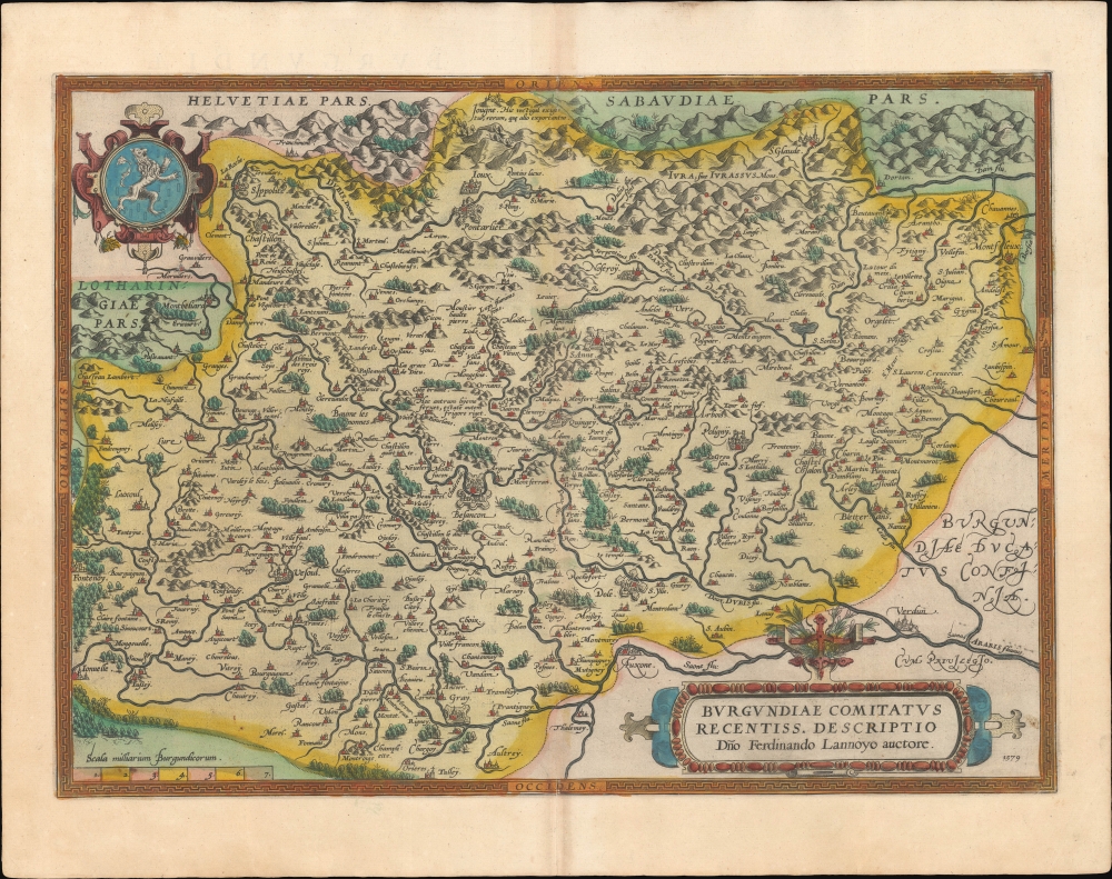
A beautiful example, in superb original color, of Abraham Ortelius' 1579 map of Burgundy. It conforms to the eastern part of modern-day Bourgogne-Franche-Comté. It is the first of four maps Ortelius produced of Burgundy, one of the world's most famous wine-producing regions.
A Closer Look
The east-oriented map embraces from the Saône River to the Alpine borders with Switzerland and the Duchy of Savoy. It is centered on Besançon, and includes the cities of Pontarlier, Gray, Dole, Auxonne, and Luxeuil, among others. The mountainous topography appears pictorially, and major cities are illustrated with fortifications. The arms of the Franche-Comté appear in the upper left.
While the book's first edition was released in 1570, Ortelius continually improved the work - both by adding new maps, and by refining the production of the book. Maps appearing in editions of the Theatrum in the 1580s and 1590s generally display, as here, a finer quality of color than those in the earlier issues of the work.Sources
The map is based on an unobtainable 1563 map of Burgundy made by Ferdinand de Lannoy (1510 - 1579) considered the first to depict Franche-Comté. Although Lannoy had a privilege for the map, it was suppressed by the Spanish crown for political reasons. Nonetheless, Ortelius obtained a copy of the map as early as 1570 and used it as the cartographic basis of this map. Historical Context
At the time this map was produced, this region was not part of France, rather it was a fief of the Holy Roman Empire until 1678. The name Franche-Comté derives from the German title of its feudal lord, Freigraf, or 'free count.' It passed from time to time into French hands, but according to the 1493 Treaty of Senlis, Franche-Comté was ceded to Emperor Maxmilian and his son Philip I of Castile. In 1563 when Ferdinand de Lannoy's map was drafted, the county was a territory of Habsburg Spain. Since it shared borders with the French Duchy of Burgundy, Switzerland, and Savoy, it held a valuable strategic position - one which became crucial during the Eighty Years' War (1568 - 1648).Key Position in the 'Spanish Road'
In 1566, Fernando Álvarez de Toledo y Pimentel, Third Duke of Alban, was sent with a Spanish force to suppress political and religious unrest. As Alban's army was stationed in Lombardy, and sea transport was impractical, a land route from Lombardy to the Spanish Netherlands was surveyed: The Spanish Road, which Alba used in 1567. It ran from the Duchy of Milan through Savoy, Franche-Comté, and Lorraine before reaching Luxembourg. Spanish forces continued to use The Spanish Road for the next thirty years until the 1601 loss of Savoy to the French.
De Lannoy improved his 1563 map of Franche-Comté, with the intention of publishing in Antwerp. In 1565, he contracted engraver Hieronymus Cock to cut the plates, and the map was printed by 1568 when Alba - doubtless with the security of The Spanish Road in mind - called for the map's suppression and the destruction of the plates. Alba's agent paid Cock a hundred pieces to do so.
Despite Alba's efforts, at least one example survived, which Ortelius acquired as early as 1570. Possibly to protect his source, Ortelius did not add the map to the Theatrum until after de Lannoy's 1579 death.Publication History and Census
This map was engraved and first added to the Ortelius Atlas in 1570. It is the first state, corresponding to Ort 51.1. The present example conforms typographically to the 1595 Latin edition of the Theatrum (1595L31), of which 500 copies were printed. This map is well represented in institutional collections and appears on the market from time to time.
CartographerS
Abraham Ortelius (April 14, 1527 - June 28, 1598) also known as Ortels, was a cartographer, geographer, and cosmographer of Brabant, active in Antwerp. He was the creator of the first modern atlas, Theatrum Orbis Terrarum and is a seminal figure in the history of cartography. Along with Gerard Mercator and Gemma Frisius, he was a founder of the Netherlandish school of cartography. His connections with Spain - culminating in his 1575 appointment as Royal Cartographer to King Phillip II of Spain - gave him unmatched access to Spanish geographical knowledge during a crucial period of the Age of Discovery. Ortelius was born in 1527 in Antwerp. In 1547 he entered the Antwerp Guild of Saint Luke as an illuminator of maps. He began trading in books, prints, and maps, traveling regularly to the Frankfurt book and print fair, where in 1554 he met Mercator. He accompanied Mercator on journeys throughout France in 1560 and it was at this time, under Mercator's influence, that he appears to have chosen his career as a scientific geographer. His first published geographic work appeared in 1564, an eight-sheet cordiform world map. A handful of other maps preceded the 1570 publication of the first edition of the Theatrum Orbis Terrarum, which would prove to be his life work. Appearing with but 53 maps in its first edition, Ortelius' work expanded with new maps added regularly. By 1592, it had 134 maps. Many of Ortelius' maps remained the standard for nearly a century. He traveled extensively, but his genius was as a compiler, locating the best informed maps on which to base his own. His contacts throughout Europe and extending even (via the Portuguese) to the Far East were formidable. Moreover, many of his maps were based on his own scholarship, particularly his historical works. His theories of geography were particularly ahead of his time with respect to the notion of continental drift, the possibility of which he mused on as early as 1596, and which would be proven correct centuries later.
In a sense his greatest achievement was his successful navigation of the religious and political violence endemic to his city throughout his adult life: The Dutch Revolt, or Eighty Years' War (1568 - 1648), fully embroiled Antwerp. Although outwardly and officially recognized as Catholic (Arias Montanus vouched for Ortelius' Catholic orthodoxy prior to his appointment as Royal Geographer), Ortelius was able to separate himself from the religious furor which characterized the war in the low countries. Ortelius showed a glimpse of himself in a letter to a friend, regarding humanist Justus Lipsius: 'I do not know whether he is an adherent of the Pope or a Calvinist, but if he has ears to hear, he will neither be one nor the other, for sins are committed on both sides'. Ortelius' own explorations of Biblical history in his maps, and the Christogram contained in his own motto, suggest him to be a religious man, but his abjuration of political religious authorities mark him as an individualist. His tombstone at St Michael's Præmonstratensian Abbey in Antwerp bears the inscription, Quietis cultor sine lite, uxore, prole. ('served quietly, without accusation, wife, and offspring.') More by this mapmaker...
Ferdinand de Lannoy (1510 - 1579) was a Flemish duke, soldier, engineer and cartographer in the service of Spain and the the Holy Roman Empire. He was born in Italy to Charles de Lannoy, governor of Tournai and viceroy of Naples. Ferdinand was educated in Italy, focusing on mathematics, topography and mapmaking. He began a military career, primarily serving in the religious wars fighting German Protestants. He rose to a generalship of artillery during his wars in Germany, Italy and Flanders. In 1560 he returned to a domestic, academic life, devoting himself to cartography. He completed in 1563 a map of the county of Burgundy - the first known map of Franche-Comté - and earned recommendations which won him the governorship of the city of Gray the following year. The appointment gave him abundant opportunity to improve his map, which he intended to publish. In 1565 he began negotiations with Antwerp engraver Hierronymus Cock to cut the plates, and the printed maps were even completed when, at the behest of the Duke of Alba, the map - detailing as it did a region crucial to Spain's efforts in the Eighty Years' War - was suppressed and the plates destroyed. At least one copy survived, however: Abraham Ortelius was aware of the map as far back as 1570, and on the year of de Lannoy's death the Antwerp mapmaker would publish his version of the map in his atlas. Learn More...
Source
Ortelius, A., Theatrum Orbis Terrarum, (Antwerp: Plantin) 1595.
Abraham Ortelius' magnum opus, Theatrum Orbis Terrarum, was the world's first regularly produced atlas, which 'set the standards for later atlases . . . It was the first undertaking of its kind to reduce the best available maps to an uniform format.' (Koeman) A modestly-sized work of fifty-three maps in its first edition of May 1570, it was an immediate success: there were three further editions that year, and the work remained in print for a total of 32 editions, the last of which was 1641, well after its author's 1598 death. Ortelius added to his atlas constantly, and by 1595 the Theatrum contained 147 maps. Ortelius is renowned generally as an editor, and indeed much of the Theatrum is compiled from a variety of sources: in such cases, Ortelius was scrupulous in naming his sources. But Ortelius was also a mapmaker in his own right: many of his maps are a distillation of various sources into his own work, and there were many maps - particularly in his atlas of Biblical and ancient history Parergon - which were entirely Ortelius' work. In his role as an editor, Ortelius followed in the footsteps of Munster, whose Cosmographia was, until Ortelius, the best window on the world for the curious European reader. In terms of the artistry of his maps, Ortelius oversaw the first great flourishing of copperplate engraving in the service of cartography to occur in Northern Europe. Ortelius' work provided the model for the atlases of Mercator, Hondius, Blaeu and all their progeny in the 17th century - many of whom were to produce faithful editions of Ortelius' maps in their own productions.
Very good. Generous margins. Superb original color. Slight foxing. Minor verso repair, bottom centerfold.
Ort 51 (Koeman/Meurer: 78, Karrow: 1/113, van der Krogt AN: 4880:31A).