1780 Bellin Map of Brazil
Brazil-bellin-1780$250.00

Title
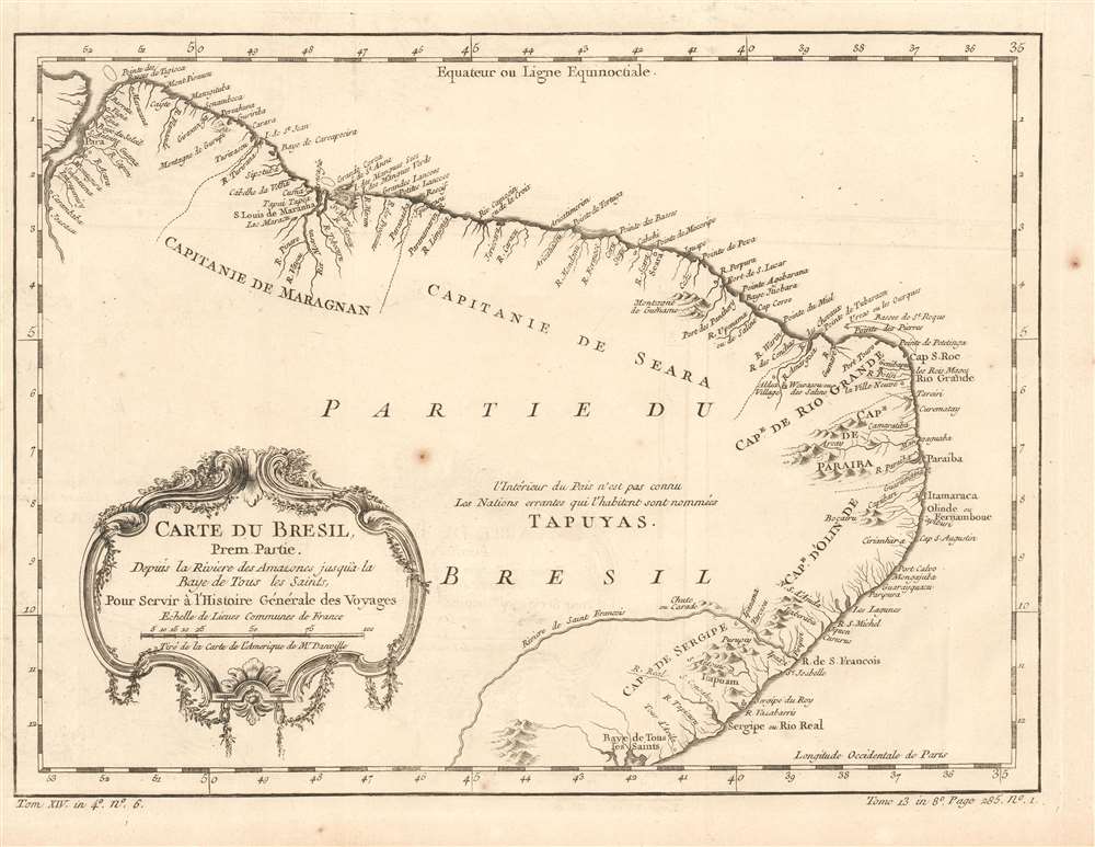
Carte du Bresil, Prem. Partie Depuis la Riviere des Amazones jusquà la Baye de Tous es Saints, Pour Servir à l'Histoire Générale des Voyages.
1780 (undated) 9.5 x 12.75 in (24.13 x 32.385 cm) 1 : 6500000
1780 (undated) 9.5 x 12.75 in (24.13 x 32.385 cm) 1 : 6500000
Description
This is a beautifully engraved 1780 map of the coast of Brazil, extending from the mouth of the Amazon River to the Baía de Todos los Santos. It names and marks the coastal borders of the Portuguese colonial Captaincies of Maranhão, Ceará, Rio Grande do Norte, Paraiba, Olinda (actually Pernambuco, of which Olinda was the capital), and Sergipe. Coastal settlements and the mouths of rivers are named, and prominent mountain ranges near coastal areas are shown pictorially. While most rivers are not shown at length, the Rio São Francisco does appear, and its sharp turn to the southwest is suggestive of the actual course of that river. Waterfalls are marked in the vicinity of the Paulo Afonso Falls, and settlements are named along the lower course of the river.
The Interior
Away from the coastline the map is largely blank, with a text note in French indicating that The interior of the country is unknown; the nomadic nations who live in it are named 'Tapuyas.' This refers to the Pira-tapuya, who now live in the extreme headwaters of the Amazon tributary regions along the Vaupés River in Colombia and in the state of Amazonas, Brazil. Their estimated numbers, as of 2014, have dwindled to less than two thousand.Publication History and Census
The separate map appears on the market from time to time but is somewhat neglected in institutional collections: OCLC lists perhaps fifteen examples of this map in its various editions. La Harpe's Abrégé de l'histoire générale des voyages is well represented in institutions.Cartographer
Jacques-Nicolas Bellin (1703 - March 21, 1772) was one of the most important cartographers of the 18th century. With a career spanning some 50 years, Bellin is best understood as geographe de cabinet and transitional mapmaker spanning the gap between 18th and early-19th century cartographic styles. His long career as Hydrographer and Ingénieur Hydrographe at the French Dépôt des cartes et plans de la Marine resulted in hundreds of high quality nautical charts of practically everywhere in the world. A true child of the Enlightenment Era, Bellin's work focuses on function and accuracy tending in the process to be less decorative than the earlier 17th and 18th century cartographic work. Unlike many of his contemporaries, Bellin was always careful to cite his references and his scholarly corpus consists of over 1400 articles on geography prepared for Diderot's Encyclopedie. Bellin, despite his extraordinary success, may not have enjoyed his work, which is described as "long, unpleasant, and hard." In addition to numerous maps and charts published during his lifetime, many of Bellin's maps were updated (or not) and published posthumously. He was succeeded as Ingénieur Hydrographe by his student, also a prolific and influential cartographer, Rigobert Bonne. More by this mapmaker...
Source
De la Harpe, Abrégé de l'histoire générale des voyages. (Paris), 1780.
Condition
Very good condition. Left margin close but complete. Few minor spots, else excellent with a bold, sharp strike.
References
OCLC 163341738.