1788 Bonne Map of Northern Brazil, Guyana, the Amazon
Brazil-bonne-1788$125.00

Title
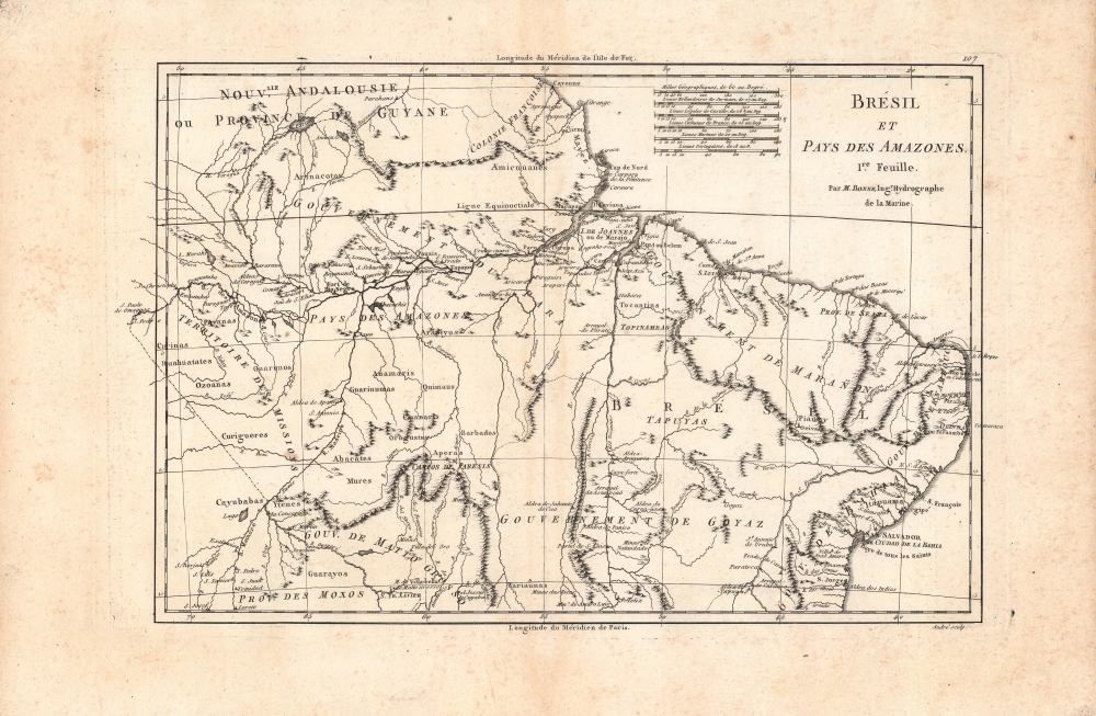
Brésil et pays des Amazones, 1re Feuille.
1788 (undated) 9.24 x 14.25 in (23.4696 x 36.195 cm) 1 : 11000000
1788 (undated) 9.24 x 14.25 in (23.4696 x 36.195 cm) 1 : 11000000
Description
A fine example of Rigobert Bonne's c. 1788 map of northern Brazil, which appeared in his and Nicolas Desmarest's Atlas Encyclopedique. It focuses on the Amazon River and its tributaries as well as the mountainous interior further to the south.
A Closer Look
This detailed map features the northern portion of Brazil from Bahia to Guyana, including the lower portion of the Amazon River and its adjacent rainforest. Rivers, lakes, mountains, settlements, indigenous tribes, and administrative divisions are noted throughout. Both the Ferro and Paris Meridian are included, along with six different scales. Of note is the legendary Lake Parime in the northwest. It was on the shores of this lake that many explorers mistakenly believed they could find the city of Manoa, or El Dorado.Publication History and Census
This map was drawn by Rigobert Bonne and engraved by André, about whom little is known. It appeared as map No. 107 in Volume II of Bonne and Nicolas Desmarest's Atlas Encyclopedique, a very successful atlas that went through several editions in the late 18th century. The map is similar though not identical to Bonne's earlier c. 1780 map in his and Guillame Thomas Raynal's Atlas de Toutes les Parties Connues du Globe Terrestre. As the subtitle suggests, it was paired with Feuille II (No. 106), covering a portion of the Atlantic coast of South America extending south to Buenos Aires, which somewhat confusingly directly preceded it in the atlas. The present map is only independently cataloged (as part of the pair) among the holdings of the University of California Los Angeles and DePaul University, while the entire Atlas Encyclopedique is more widely distributed among universities and research institutions.Cartographer
Rigobert Bonne (October 6, 1727 - September 2, 1794) was one of the most important French cartographers of the late 18th century. Bonne was born in Ardennes à Raucourt, France. He taught himself mathematics and by eighteen was a working engineer. During the War of the Austrian Succession (1740 - 1748) he served as a military engineer at Berg-op-Zoom. It the subsequent years Bonne became one of the most respected masters of mathematics, physics, and geography in Paris. In 1773, Bonne succeeded Jacques-Nicolas Bellin as Royal Cartographer to France in the office of the Hydrographer at the Depôt de la Marine. Working in his official capacity, Bonne compiled some of the most detailed and accurate maps of the period - most on an equal-area projection known erroneously as the 'Bonne Projection.' Bonne's work represents an important step in the evolution of the cartographic ideology away from the decorative work of the 17th and early 18th century towards a more scientific and practical aesthetic. While mostly focusing on coastal regions, the work of Bonne is highly regarded for its detail, historical importance, and overall aesthetic appeal. Bonne died of edema in 1794, but his son Charles-Marie Rigobert Bonne continued to publish his work well after his death. More by this mapmaker...
Source
Bonne, Rigobert and Desmarest, N., Atlas encyclopédique contenant la géographie ancienne, et quelques cartes sur la géographie du moyen age, la geographie moderne, et les cartes relatives a la géographie physique, (Paris) 1787-1788.
Condition
Good. Foxing throughout, more prominent in the margins and along centerfold.
References
OCLC 759209460.