This item has been sold, but you can get on the Waitlist to be notified if another example becomes available, or purchase a digital scan.
1730 Seutter Map of Brazil
Brazil-seutter-1730$175.00

Title
Recens elaborata mappa geographica regni Brasiliae in America Meridionali maxime celebris…
1730 (undated) 20 x 23 in (50.8 x 58.42 cm) 1 : 6000000
1730 (undated) 20 x 23 in (50.8 x 58.42 cm) 1 : 6000000
Description
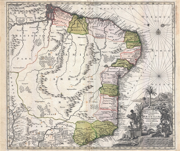
A very attractive 1730 map of Brazil by the Augsburg cartographer Matthaeus Seutter. The map covers Brazil from the mouth of the Amazon River to the city of São Paulo and from the Paraguay River to the Atlantic seaboard. In addition to Brazil, it also features parts of Paraguay. Cartographically, Seutter derived this map form Joan Blaeu's 1650 Nova et Accurata Totius Brasiliae Tabula. Bothe the coverage and content are very similar, offering great insight in the fact that in the intervening 100 years, no significant cartographic advancement regarding the mapping of the interior occurred. Speculative mountain ranges and indigenous tribal groups are noted, but there is little certainly. Lake Parima, the semi-fictional location of the supposed golden city of El Dorado, peaks in from behind the border in the upper left quadrant. There is an elaborate decorative title cartouche in the lower right. The cartouche features black skinned men harvesting sugar for export – at the time sugar was the driving force behind Brazil's economy.
Cartographer
Matthäus Seutter (1678 - 1757) was one of the most important and prolific German map publishers of the 18th century. Seutter was born the son of a goldsmith but apprenticed as a brewer. Apparently uninspired by the beer business, Seutter abandoned his apprenticeship and moved to Nuremberg where he apprenticed as an engraver under the tutelage of the prominent J. B. Homann. Sometime in the early 1700s Seutter left Homann to return to Augsburg, where he worked for the prominent art publisher Jeremiad Wolff (1663 - 1724), for whom he engraved maps and other prints. Sometime around 1717 he established his own independent cartographic publishing firm in Augsburg. Though he struggled in the early years of his independence, Seutter's engraving skill and commitment to diversified map production eventually attracted a substantial following. Most of Seutter's maps are heavily based upon, if not copies of, earlier work done by the Homann and De L'Isle firms. Nonetheless, by 1731/32 Seutter was one of the most prolific publishers of his time and was honored by the German Emperor Karl VI who gave him the title of Imperial Geographer, after which most subsequent maps included the Avec Privilege designation. Seutter continued to publish until his death, at the height of his career, in 1757. Seutter had two engraver sons, Georg Matthäus Seutter (1710 - 173?) and Albrecht Carl Seutter (1722 - 1762). Georg Matthäus quit the business and relocated to Woehrdt in 1729 (and probably died shortly thereafter), leaving the family inheritance to his wastrel brother Albrecht Carl Seutter, who did little to advance the firm until in own death in 1762. Following Albrecht's death, the firm was divided between the established Johann Michael Probst (1727 - 1776) firm and the emerging firm of Tobias Conrad Lotter. Lotter, Matthäus Seutter's son-in-law, was a master engraver and worked tirelessly on behalf of the Suetter firm. It is Lotter, who would eventually become one of the most prominent cartographers of his day, and his descendants, who are generally regarded as the true successors to Matthäus Seutter. (Ritter, M. Seutter, Probst and Lotter: An Eighteenth-Century Map Publishing House in Germany., "Imago Mundi", Vol. 53, (2001), pp. 130-135.) More by this mapmaker...
Source
Cassini, G. M., Nuovo Atlante Geografico Universale, (Roma : Presso la Calcografia Camerale) 1797.
Condition
Good condition. Light foxing. Centerfold wear. Blank on verso. Platemark visible.
References
OCLC 54650256. Boston Public Library, Leventhal Center, G5400 1730 .