Title
Mappa da viação ferrea dos E.U. do Brasil e da Rep. do Uruguay / Planta geral da Cidade de São Paulo.
1946 (dated)
25.5 x 36 in (64.77 x 91.44 cm)
1 : 2000000
Description
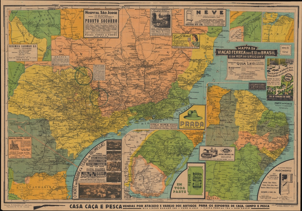
A large and visually stunning 1946 railway map of Brazil and Uruguay, edited by M. Miglino and Cia, printed by Impressão da Sarcinelli, and published in the Guia Levi, a popular manual of train schedules and routes. The verso includes a detailed plan of São Paulo, adding to the map's considerable utility.
A Closer Look
Bright and busy, the recto includes a main map at left along with five insets and more than a dozen advertisements. The main map displays the Brazilian coast from Caravelas to Florianópolis, taking in the cities of Rio de Janeiro and São Paulo, among others, with states color-shaded for easy distinction. Roads and railways (including those under construction) are traced, with the distance of major roads between cities and towns noted, which are recorded in profusion. River ports, radio towers, rivers, and other features are also marked.
The inset maps, clockwise from top-left, are a map of the interior region of Mato Grosso (do Sul) around Campo Grande; a map of the territory of Guaporé, the predecessor to today's state of Rondônia, on the border with Bolivia; a map of the vicinity of Belém in northern Brazil; a large inset at bottom-right, covering from São Luís to Ilhéus, taking in the city of Bahia (now Salvador); and an inset of the Brazilian state of Rio Grande do Sul, Uruguay, and a portion of Argentina, including Buenos Aires at bottom.
The advertisements reflect a developing consumer economy. They tend to split between those aimed at urbanites - coffee, refrigerators, furniture, and appliances - and those directed at farmers - tractors, medications for domesticated animals, and fishing and hunting gear. Perhaps most noticeable is a colorful advertisement for Prada hats near center, though this appears to be a different company than the now-world-famous Italian fashion designer. Another conspicuous illustration sits to the right of the title cartouche, promoting the upscale neighborhood of Jardim da Saúde (Garden of Health), planned as a 'garden neighborhood' in the style of Ebenezer Howard's garden cities.A Slice of England in the Brazilian Interior
At bottom towards left is a promotional advertisement titled, 'The North of Paraná [State] is a Land of Promise'. This resource-rich region, centered on the curiously named city of Londrina, attracted immigrants from a range of European countries (and Japan) in the late 19th and early 20th century. Relatively late in this process, a group of Brits arrived who prioritized railways and built up the city named for their imperial capital. This led to its explosive growth in the 1920s - 1930s (from less than 1,500 inhabitants in 1920 to over 27,000 by 1930). Similar blocks of promotional text, without matching visuals, promote the cities of Poços de Caldas and Franca.Verso Map of São Paulo
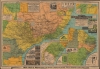
An uncolored map of São Paulo occupies the verso, with streets traced and named, along with neighborhoods, rail lines, rail stations, parks, the Rio Tietê and other waterways, hospitals, government offices, major enterprises, orphanages, prisons, sporting venues, and other features. Two insets, displaying the city center and the Santo Amaro district, respectively, appear, along with additional advertisements. Having already grown considerably with the onset of industrialization at the turn of the 20th century, São Paulo entered a golden age following the Revolution of 1932, which was rooted in the city. Although the revolt failed, São Paulo saw considerable economic development in the following years, aided by infrastructure projects, industrial-friendly policies, and greater aid and investment from the United States.The Development of Brazil's Railways
The early history of Brazil's railways is tied closely to the country's key agricultural industries - especially coffee - and the demand to quickly transport agricultural goods to the coast for export. Connections with the outside world also proved crucial in the investment of capital (especially British and American) and importing technical know-how necessary to build railways. A railway building spree peaked around the turn of the 20th century, resulting in the extensive network seen here and the opening of the country's interior to greater settlement and economic development. Around the time of this map's publication, the rail network was increasingly electrified or switched from steam locomotives to diesel locomotives.Publication History and Census
This map was edited by M. Miglino and Cia and printed by Impressão da Sarcinelli, two companies that appear to have worked exclusively with Guia Levi. As referenced on the verso, the guides were at this time published monthly to provide the most up-to-date information on railway schedules. At the same time, the accompanying maps only appear to have been updated annually (though they are not always dated). The present edition of the map is independently cataloged in the OCLC among the holdings of the University of California Berkeley, California State University, Northridge, the University of Minnesota Twin Cities, and Harvard University. Other editions of the map, dating from the 1920s into the 1950s, are similarly scarce in institutional collections.
Cartographer
Guia Levi (1897 - 1984) was a Brazilian monthly periodical containing passenger rail timetables and often a corresponding railway map of Brazil. At its peak, it was the most prevalent railway guide employed by Brazilian rail passengers. In its final years, as passenger rail declined, the publication was only published annually instead of monthly. More by this mapmaker...
Condition
Good. Light wear along original folds. Some loss at fold junctions. Several small tears along borer professionally repaired. Several faint handwritten annotations. Map on verso.
References
OCLC 39697607.