1851 Tallis Map of Canada or British America
BritishAmerica-tallis-1851$275.00

Title
British America.
1851 (undated) 12.75 x 10.5 in (32.385 x 26.67 cm) 1 : 22176000
1851 (undated) 12.75 x 10.5 in (32.385 x 26.67 cm) 1 : 22176000
Description
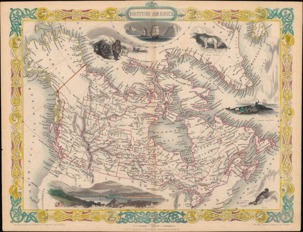
A scarce state of John Tallis and John Rapkin's c. 1851 map of British America or Canada. Among other features, it depicts the vast territory overseen by the Hudson's Bay Company.
Around the map are numerous decorative vignettes typical of Rapkin and Tallis' work, including a seal, whale fishing, the exploring ships Fury and Hecla, a polar bear, some Esquimaux (Eskimos), and a view of 'Hudson City,' the most inexplicable feature of the map. The earliest edition (1849) of the map, previously sold by us, included the same view but captioned it 'Boston City,' also mysterious as the view does not resemble the city of Boston in Massachusetts (particularly the mountains in the background), nor the small town of Boston in Ontario. Later editions of this map would replace the Boston/Hudson City view with one of Montreal. The enigma of this unusual view remains unsolved; Tallis and his collaborators may have simply misunderstood North American geography, or perhaps Boston and Hudson were ephemeral names for a portion of Montreal, though we have been unable to locate any historical evidence of this. Hudson City may be the city of Hudson, N.Y., on the river of the same name, which was an important transit point between Canada and Boston as well as New York.
A Closer Look
Covering nearly all of today's Canada, as well as Alaska (Russian America), this map notes rivers, lakes, forts, settlements, trading posts or houses, mountain ranges, administrative borders, and coastal features such as bays, capes, and islands. Aside from East and West Canada, as well as other established colonies in the east like Nova Scotia and Newfoundland, most of the territory seen here was under the technical purview of the Hudson's Bay Company, though aside from a series of forts and trading posts, its presence was limited. Extremely wealthy and intent on guarding against potential competitors, the Hudson Bay Company absorbed its rival, the North-West Company, in 1821. It vied with John Jacob Astor's American Fur Company along the western frontier, including the Pacific Coast. An American Fur Company post can be seen on Lake Superior in the vicinity of Duluth, Minnesota, while several forts and trading houses of the Hudson's Bay Company can be seen in what became the U.S. state of Washington. This map would have been prepared soon after the U.S.-British dispute over the Oregon Territory had mainly been settled in an 1846 treaty. However, disagreements and tensions remained until an international boundary dispute tribunal resolved the issue in 1872.Around the map are numerous decorative vignettes typical of Rapkin and Tallis' work, including a seal, whale fishing, the exploring ships Fury and Hecla, a polar bear, some Esquimaux (Eskimos), and a view of 'Hudson City,' the most inexplicable feature of the map. The earliest edition (1849) of the map, previously sold by us, included the same view but captioned it 'Boston City,' also mysterious as the view does not resemble the city of Boston in Massachusetts (particularly the mountains in the background), nor the small town of Boston in Ontario. Later editions of this map would replace the Boston/Hudson City view with one of Montreal. The enigma of this unusual view remains unsolved; Tallis and his collaborators may have simply misunderstood North American geography, or perhaps Boston and Hudson were ephemeral names for a portion of Montreal, though we have been unable to locate any historical evidence of this. Hudson City may be the city of Hudson, N.Y., on the river of the same name, which was an important transit point between Canada and Boston as well as New York.
Publication History and Census
This map was drawn and engraved by John Rapkin, with illustrations drawn by H. Warren and engraved by R. Wallis, and was published by John Tallis. This rare state comes from John Howard Hinton's The History and Topography of the United States, published in Britain by Tallis at some point between 1850 and 1852, more likely towards the earlier part of that range. Hinton's book was popular and went through multiple printings in the U.S. and Britain, with different plates added depending on the publisher; Tallis naturally used his own maps.CartographerS
John Tallis and Company (1838 - 1851) published views, maps, and atlases in London from roughly 1838 to 1851. Their principal works, expanding upon the earlier maps of John Cary and Aaron Arrowsmith, include an 1838 collection of London Street Views and the 1849 Illustrated Atlas of the World. The firm’s primary engraver was John Rapkin, whose name and decorative vignettes appear on most Tallis maps. Due to the embellishments typical of Rapkin's work, many regard Tallis maps as the last bastion of English decorative cartography in the 19th century. Although most Tallis maps were originally issued uncolored, it was not uncommon for 19th century libraries to commission colorists to "complete" the atlas. The London Printing and Publishing Company of London and New York bought the rights for many Tallis maps in 1850 and continued issuing his Illustrated Atlas of the World until the mid-1850s. Specific Tallis maps later appeared in innumerable mid to late-19th century publications as illustrations and appendices. More by this mapmaker...
John Rapkin (July 18, 1813 - June 20, 1899) was an English mapmaker and engraver. Born in Southwark, Rapkin was the son of George Rapkin, a shoemaker, and his wife Elizabeth Harfy. Rapkin and his brother Richard both became engravers and his other brother, William Harfy Rapkin, became a copperplate printer. Rapkin produced works for James Wyld and John Tallis, including The United States and the relative position of Oregon and Texas for Wyld around 1845, and a series of eighty maps for Tallis that became 'Tallis's illustrated atlas, and modern history of the world' in 1851. Rapkin married Frances Wilmot Rudell on January 4, 1837, with whom he had at least eight children, some of whom became engravers, including his sons John Benjamin Rapkin (1837 - 1914), Alfred Thomas Rapkin (1841 - 1905), Joseph Clarke Rapkin (1846? - 1912), and Frederick William Rapkin (1859 - 1945). Rapkin operated under the imprint 'John Rapkin and Sons from 1867 until 1883, and was operating as 'John Rapkin and Sons' by 1887. Rapkin died in 1899 at the age of 85 soon after the death of his wife of over sixty years. Learn More...
Source
Hinton, J. Howard, The History and Topography of the United States, (Talis) c. 1851.
Condition
Very good. Wear and some toning along centerfold.
References
Rumsey 0466.067. Phillips 804-6.