Digital Image: 1937 Alonzo C. Webb map of the British Empire - original manuscript
BritishEmpire-webb-1937_d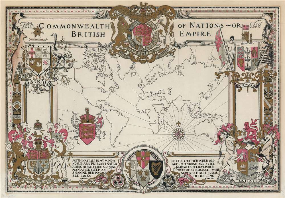

Title
The Commonwealth of Nations or, The British Empire.
1937 (undated) 15.5 x 22 in (39.37 x 55.88 cm)
1937 (undated) 15.5 x 22 in (39.37 x 55.88 cm)
Description
FOR THE ORIGINAL ANTIQUE MAP, WITH HISTORICAL ANALYSIS, CLICK HERE.
Digital Map Information
Geographicus maintains an archive of high-resolution rare map scans. We scan our maps at 300 DPI or higher, with newer images being 600 DPI, (either TIFF or JPEG, depending on when the scan was done) which is most cases in suitable for enlargement and printing.
Delivery
Once you purchase our digital scan service, you will receive a download link via email - usually within seconds. Digital orders are delivered as ZIP files, an industry standard file compression protocol that any computer should be able to unpack. Some of our files are very large, and can take some time to download. Most files are saved into your computer's 'Downloads' folder. All delivery is electronic. No physical product is shipped.
Credit and Scope of Use
You can use your digial image any way you want! Our digital images are unrestricted by copyright and can be used, modified, and published freely. The textual description that accompanies the original antique map is not included in the sale of digital images and remains protected by copyright. That said, we put significant care and effort into scanning and editing these maps, and we’d appreciate a credit when possible. Should you wish to credit us, please use the following credit line:
Courtesy of Geographicus Rare Antique Maps (https://www.geographicus.com).
How Large Can I Print?
In general, at 300 DPI, you should at least be able to double the size of the actual image, more so with our 600 DPI images. So, if the original was 10 x 12 inches, you can print at 20 x 24 inches, without quality loss. If your display requirements can accommodate some loss in image quality, you can make it even larger. That being said, no quality of scan will allow you to blow up at 10 x 12 inch map to wall size without significant quality loss. For more information, it is best consult a printer or reprographics specialist.
Refunds
If the high resolution image you ordered is unavailable, we will fully refund your purchase. Otherwise, digital images scans are a service, not a tangible product, and cannot be returned or refunded once the download link is used.
Cartographer
Alonzo C. Webb (April 1, 1888 - 1974) was an American engraver, architect, painter and illustrator. Web was born in Nashville Tennessee. He attended the Art Institute of Chicago from 1907 to 1909, then enrolled in the Stout Institute of Wisconsin in 1911 to study building and construction for one year, before attaining an architecture degree at the University of Illinois (1912 - 1913). During World War I he served with American Engineering Forces in France, falling in love with that country. After the war he studied art at the A.E.F. Art Training Center in Bellevue, France, a school set up for American soldiers. Determined to stay in Paris, he give up his architectural career, which he could not practice in France, to make ends meet doing various odd illustration jobs and making sings in English for millinery shops on Rue de Rivoli. His work gradually became more popular and frequently appeared in the French weekly periodical, L'Illustration. In the 1920s and 30s he worked multinationally, producing art and architectural illustrations for American, French, and Italian interests. Webb moved to London in the 1930, remaining there until his death in 1974. More by this mapmaker...
References
Rumsey 11762.001 (printed edition).