1771 Janvier Map of the British Isles ( England, Wales, Scotland, Ireland )
BritishIsles2-janvier-1771$250.00

Title
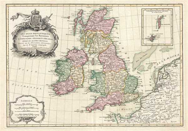
Les Isles Britanniques Comprenant les Royaumes D'Angleterre, D'Ecosse et D'Irlande divisés en Grandes Provinces.
1771 (undated) 12 x 17.75 in (30.48 x 45.085 cm) 1 : 3800000
1771 (undated) 12 x 17.75 in (30.48 x 45.085 cm) 1 : 3800000
Description
This is a 1771 Jean Janvier map of the British Isles. The map depicts England, Wales, Scotland, and Ireland, along with parts of France, Holland, and Belgium. The British Isles are divided according to province. An inset map on the upper right details the Shetland and Orkney Islands. A decorative mile scale cartouche appears in the lower left corner. A decorative title cartouche depicting the British royal armorial crest is situated in the upper left corner.
Drawn by Jean Janvier c. 1771 for issue in Jean Lattre's 1776 issue of the Atlas Moderne.
Drawn by Jean Janvier c. 1771 for issue in Jean Lattre's 1776 issue of the Atlas Moderne.
CartographerS
Jean Denis Janvier (fl. 1746 - 1776), sometime also known as 'Robert', was a Paris based cartographer active in the mid to late 18th century. Janvier signed his maps Signor Janvier. By the late 18th century, Janvier was awarded the title of 'Geographe Avec Privilege du Roi' and this designation appears on many of his later maps. Janvier worked with many of the most prominent French, English and Italian map publishers of his day, including Longchamps, Faden, Lattre, Bonne, Santini, Zannoni, Delamarche, and Desnos. More by this mapmaker...
Jean Lattré (170x - 178x) was a Paris based bookseller, engraver, globe maker, calligrapher, and map publisher active in the mid to late 18th century. Lattré published a large corpus of maps, globes, and atlases in conjunction with a number of other important French cartographic figures, including Janvier, Zannoni, Bonne and Delamarche. He is also known to have worked with other European cartographers such as William Faden of London and the Italian cartographer Santini. Map piracy and copyright violations were common in 18th century France. Paris court records indicate that Lattré brought charges against several other period map publishers, including fellow Frenchman Desnos and the Italian map engraver Zannoni, both of whom he accused of copying his work. Lattré likes trained his wife Madame Lattré (né Vérard), as an engraver, as a late 18th century trade card promotes the world of 'Lattré et son Epouse.' Lattré's offices and bookshop were located at 20 rue St. Jaques, Paris, France. Later in life he relocated to Bordeaux. Learn More...
Source
Lattre, Jean, Atlas Moderne ou Collection de Cartes sur Toutes les Parties du Globe Terrestre, c. 1775.
Condition
Very good. Original platemark visible. Blank on verso.
References
Rumsey 2612.039. Malinowski, H., The Malinowski collection of maps of Poland, 506-507, 687 (1762, 1782 eds.). Phillips (Atlases) 664. National Maritime Museum, 215. British Libarary (World), col. 384-385 (1762-1785 eds.). OCLC 50278852.