This item has been sold, but you can get on the Waitlist to be notified if another example becomes available, or purchase a digital scan.
1892 Rand McNally Map of the United States and the Burlington Railroad
BurlingtonRoute-randmcnally-1892$375.00

Title
Burlington Route.
1892 (undated) 33.25 x 45.25 in (84.455 x 114.935 cm) 1 : 4700000
1892 (undated) 33.25 x 45.25 in (84.455 x 114.935 cm) 1 : 4700000
Description
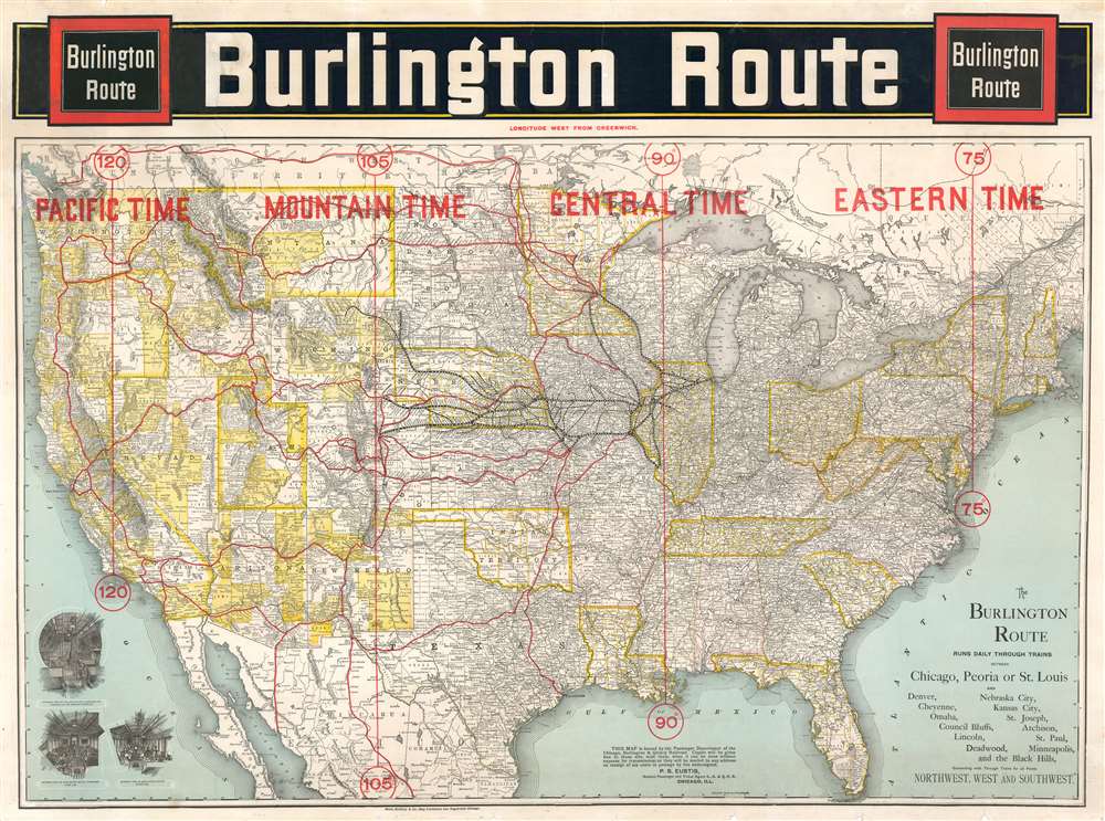
This is an 1892 large format Rand McNally map of the United States highlighting the route of the Chicago, Burlington and Quincy Railroad, commonly known as the Burlington Route. While the map covers the entire United States, the real focus are the routes extending westward from Chicago to, pretty much, the entire country. The Burlington Route is highlighted in black and many of its subsidiaries, including the Burlington and Missouri River Railroad, are also labeled. Stops along all the Burlington routes are also identified. Other major railroads in the western United States are highlighted in red, such as the Northern Pacific, Union Pacific, and Southern Pacific. Interior views in the lower left, illustrate the commodious accomiditions onboard the Burlington Route Pullman Palace Sleeping Car, passenger chair car, and dining car.
Time Zones
Perhaps the most eye-catching feature of this map is the large block lettering informing the viewer of the four time zones present in the United States: Eastern, Central, Mountain, and Pacific Time. Time zones, universally adopted in the United States on Sunday, November 18, 1883, were created to standardize railroad times across all the railroads operating within the U.S. Before the implementation of time zones, each railroad operated on its own standard time. In practice, this meant that railroad junctions served by several different railroads had several different clocks, one for each railroad, all set to different times. Universal adoption of standard time was not immediate, and it would not be until the Standard Time Act was adopted on March 19, 1918 that the practice was formally adopted across the country.Publication History and Census
This map was created by Rand McNally for the Chicago, Burlington and Quincy Railroad and published in 1892. Rare. Four examples are recorded in the OCLC as being part of the institutional collections at the Library of Congress, Pennsylvania State University, the University of Illinois at Chicago and the University of California Berkeley.Cartographer
Rand, McNally and Co. (fl. 1856 - present) is an American publisher of maps, atlases and globes. The company was founded in 1856 when William H. Rand, a native of Quincy, Massachusetts, opened a print shop in Chicago. Rand hired the recent Irish immigrant Andrew McNally to assist in the shop giving him a wage of 9 USD per week. The duo landed several important contracts, including the Tribune's (later renamed the Chicago Tribune) printing operation. In 1872, Rand McNally produced its first map, a railroad guide, using a new cost effective printing technique known as wax process engraving. As Chicago developed as a railway hub, the Rand firm, now incorporated as Rand McNally, began producing a wide array of railroad maps and guides. Over time, the firm expanded into atlases, globes, educational material, and general literature. By embracing the wax engraving process, Rand McNally was able to dominate the map and atlas market, pushing more traditional American lithographic publishers like Colton, Johnson, and Mitchell out of business. Eventually Rand McNally opened an annex office in New York City headed by Caleb S. Hammond, whose name is today synonymous with maps and atlases, and who later started his own map company, C. S. Hammond & Co. Both firms remain in business. More by this mapmaker...
Condition
Good. Mounted on heavy linen. Manuscript infill in upper left corner. Blank on verso.
References
OCLC 42954681.