1944 Chapin Map of Burma / Myanmar during World War II
BurmaDoubleGamble-chapin-1944$400.00

Title
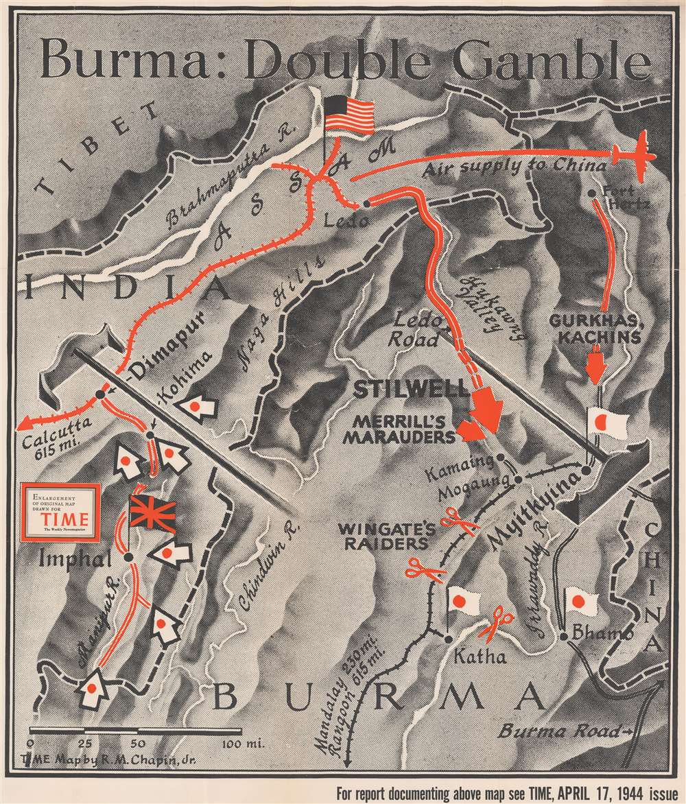
Burma: Double Gamble.
1944 (dated) 37.75 x 32.25 in (95.885 x 81.915 cm) 1 : 633600
1944 (dated) 37.75 x 32.25 in (95.885 x 81.915 cm) 1 : 633600
Description
This is a large format separately issued 1944 Robert M. Chapin Jr. map of northeastern India and northern Burma. The map depicts the simultaneous Japanese 'Operation U Go' and the 'Allied Myitkyina Offensive' as they were happening - thus representing the climax of World War II in Burma. Red lines in India mark the railway line connecting Calcutta with Dimapur and the airfields to Dimapur's north. These airfields were the only way for Allied supplies to reach Chiang Kai-shek and the Chinese nationalists, as the Burma Road had been severed in 1942 by a Japanese attack. Dimapur was also the main communication link between Allied commanders in Calcutta and the troops fighting the Myitkyina Offensive. Both these facts made Dimapur a prime target for the Japanese. Parallel red lines into Burma mark the road from Dimapur to Kohima and Imphal, as well as the general direction followed by General Stilwell during the Myitkyina Offensive. Merrill's Marauders, Wingate's Raiders, and the Gurkhas and Kachins, all irregular Allied fighting forces, are referenced as well.
The Japanese Operation U Go, and the Battles of Imphal and Kohima
The Japanese launched Operation U Go on March 6, 1944 with the goal of capturing both Imphal and Kohima in India. Once those two cities had fallen, the Japanese planned to march on Dimapur and sever the railway sending supplies to Chinese nationalists, who the Japanese had been fighting in China since 1937. Hard fighting lasted through March and April, and in May the Allied IV Corps launched a counter-offensive that pushed the Japanese out of the area. By late June, the Japanese were in full retreat, its soldiers suffering from disease and starvation.The Myitkyina Offensive
General Joseph Stilwell (march 19, 1883 - October 12, 1946) planned the Myitkyina Offensive, an invasion of northern Burma that resulted in the capture of the town of Myitkyina from the Japanese. Launched in April 1944, the offensive slogged through the monsoon season and ended in a costly months-long siege of Myitkyina, which finally fell on August 4, 1944. Stilwell was pleased with this result, but the soldiers under his command paid the price. One unit, the famed Merrill's Marauders, officially known as the 5307th Composite Unit, was so battle fatigued and disease ridden (a particularly virulent outbreak of amoebic dysentery severely hampered the unit's overall health) that the unit's medics continually asked for the whole unit to be relieved and sent to the rear to recuperate. Stilwell continually ignored these requests, and by the end of the siege of Myitkyina, only 130 combat-effective men remained in the 5307th, out of an original complement of 2,997.Publication History and Census
This map was originally drawn by Robert M. Chapin Jr. to accompany an article detailing the fighting in India and Burma published in TIME magazine on April 17, 1944. The present example is a separately issued enlargement of the map published in TIME. It also bears a collection stamp from the Ashtabula Public Library in Ohio on verso. We have contacted the library and confirmed that it was legally deaccessioned. Two examples of the present map are cataloged in OCLC, at Franklin and Marshall College and the Osher Map Library at the University of Southern Maine.Cartographer
Robert M. Chapin Jr. (fl. 1933 - 1970) was a prominent architect, cartographer and illustrator active during World War II and the Cold War. Chapin graduated from the University of Pennsylvania in 1933 with a degree in architecture. Since this was the height of the Great Depression, and architects in low demand, he instead took work as a staff cartographer at Newsweek. Catching the attention of Manfred Gottfried of Time, Chapin was offered an accepted a position at the head of Time's cartography department. He remained with Time for some 33 years, from 1937 to 1970, often drawn 2 - 3 new thematic maps weekly. With an architect's gift visualizing information, Chapin became a skilled informational cartographer, heading the cartography department at Time Magazine. Chapin, like Fortune Magazine chief cartographer, Richard Edes Harrison, Chapin was at the forefront of infographic propaganda cartography, a genre that matured during the World War II Era and remains popular today. Working for Time Magazine, Chapin developed a signature style for his long run of 'War Maps.' Chapin was known for his maverick airbrush technique which lead to strong color splashes and intense shading. He also incorporated celluloid stencils to illustrate bomb explosions, flags, sinking ships, and more - generating a instantly recognizable standardized style. Chapin's Time war maps were further distinctive for their use of strong bold reds as a universal symbol of hostility. Chapin graduated from the University of Pennsylvania in 1933 with a degree in architecture. Since this was the height of the Great Depression, an d architects in low demand, he instead took work as a staff cartographer at Newsweek. Catching the attention of Manfred Gottfried of Time, Chapin was offered an accepted a position at the head of Time's cartography department. He remained with Time for some 33 years, from 1937 to 1970, often drawn 2 - 3 new thematic maps weekly. Chapin live in Sharon Connecticut. More by this mapmaker...
Condition
Fair. Exhibits wear along original fold lines. Verso repairs to fold separations. Closed tears extending three (3) inches within printed area professionally repaired on verso. Exhibits several small areas of infill.
References
OCLC 320454098.