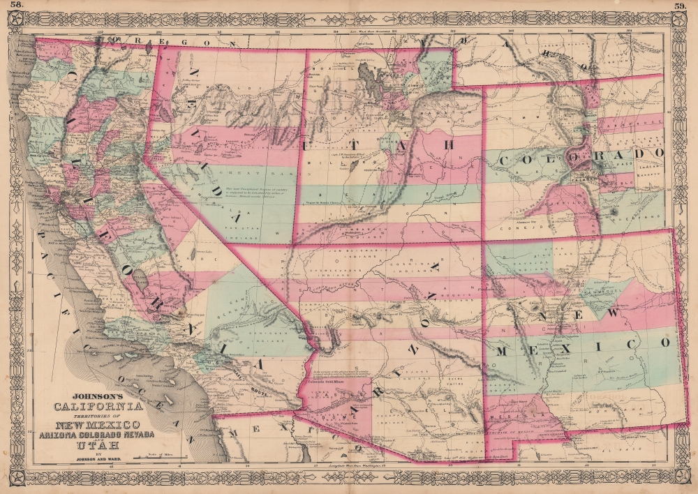
1863 Johnson Map of California, Nevada, New Mexico, Arizona, Colorado, and Utah
CaliforniaUtah-johnson-1863-2$500.00

Title
Johnson's California. Territories of New Mexico Arizona Colorado Nevada and Utah.
1863 (undated) 18 x 25.5 in (45.72 x 64.77 cm) 1 : 3424000
1863 (undated) 18 x 25.5 in (45.72 x 64.77 cm) 1 : 3424000
Description
This is A. J. Johnson's 1863 map of the American Southwest, one of the scarcest and most historically significant of his Southwest series. Published at the height of the American Civil War (1861 - 1865), this map depicts the state of California and the territories of Nevada, Utah, Colorado, New Mexico, and Arizona.
Johnson updated the plates for this map annually and sometimes even issued multiple variants over the course of a single year. Unlike most maps in the 1863 Johnson atlas, this map was a unique production and therefore not based upon the earlier atlas maps of J. H. Colton. Rather, Johnson derived this map by dissecting the plates of his 1859 wall map of North America and then incorporating, oftentimes superimposing, more contemporary detail.
This example also varies from the previous state of the map in that the California - Nevada border has been corrected to a straight line between Pyramid Peak (where several Mormon settlements are noted) and Fort Moliare. California, which enjoyed a population boost in the prior decade due to the 1849 Gold Rush, is naturally quite detailed with numerous towns, cities, mail routes, emigrant roads, and shipping lanes identified. This map also includes the routes of several exploratory missions commissioned by the U.S. Government, including Fremont, the Mexican Border Survey, Parke, Gunnison (along with the site of his tragic death), and Fredonyer.
A History of Johnson's Southwest Series
This important map went through multiple state changes during its publication period from 1860 to 1870. This critical period of westward expansion saw incredible development and change throughout the region. Collecting the various states of this map has become a sub-genre for southwestern history aficionados.Johnson updated the plates for this map annually and sometimes even issued multiple variants over the course of a single year. Unlike most maps in the 1863 Johnson atlas, this map was a unique production and therefore not based upon the earlier atlas maps of J. H. Colton. Rather, Johnson derived this map by dissecting the plates of his 1859 wall map of North America and then incorporating, oftentimes superimposing, more contemporary detail.
A Closer Look
Johnson added considerable detail in the mountainous regions of California, Nevada, and Colorado. Arizona and New Mexico appear as independent territories but, for the most part, adhere to the old 'New Mexico' county structure. The southern boundary of Nevada with Arizona is set at 37 degrees of Latitude such that Las Vegas, which is noted, rests firmly within Arizona. The Utah-Nevada Border is set at 115 degrees of Longitude, roughly one degree further west than it is today. Fillmore City is shown as the capital of Utah though Salt Lake City also appears. The Colorado Gold Region, which was first discovered in 1858, is well-labeled.This example also varies from the previous state of the map in that the California - Nevada border has been corrected to a straight line between Pyramid Peak (where several Mormon settlements are noted) and Fort Moliare. California, which enjoyed a population boost in the prior decade due to the 1849 Gold Rush, is naturally quite detailed with numerous towns, cities, mail routes, emigrant roads, and shipping lanes identified. This map also includes the routes of several exploratory missions commissioned by the U.S. Government, including Fremont, the Mexican Border Survey, Parke, Gunnison (along with the site of his tragic death), and Fredonyer.
Intriguing Detail Included on the Map
Throughout, the map is full of interesting and sometimes erroneous notations regarding natural features, Native American tribes, proposed railroads, mail routes, explorers' tracks, and treaty lines. In the arid region near modern-day Quartzite, Arizona, a note reads 'in the vicinity of this place a tract of country is found which is said by Trappers to be exceedingly fertile and abundantly timbered and well watered.' Johnson also notes silver deposits in this same region. The famed Pony Express Route is delineated as it passes through Nebraska, Utah, and Nevada on its way to California.Publication History
This map features the fretwork style border common to Johnson's atlas work from 1863 to 1869 and was published by Johnson and Ward as plate nos. 58-59 in the scarce 1863 edition of Johnson's Family Atlas. This is the second edition of the Johnson atlas to bear the Johnson and Ward imprint.Cartographer
Alvin Jewett Johnson (September 23, 1827 - April 22, 1884) was a prolific American map publisher active from 1856 to the mid-1880s. Johnson was born into a poor family in Wallingford, Vermont, where he received only a basic public education. He is known to have worked as a school teacher for several years before moving to Richmond, Virginia. Johnson got his first taste of the map business as a salesman and book canvasser for J. H. Colton. The earliest Johnson maps were published with D. Griffing Johnson (no clear relation) and date to the mid-1850s; however, it was not until 1860 that the Johnson firm published its first significant work, the Johnson's New Illustrated (Steel Plate) Family Atlas. The publication of the Family Atlas followed a somewhat mysterious 1859 deal with the well-established but financially strapped J. H. Colton cartographic publishing firm. Although map historian Water Ristow speculates that Colton sold his copyrights to Johnson and his business partner, another Vermonter named Ross C. Browning (1822 - 1899), a more likely theory is that Johnson and Browning financially supported the Colton firm in exchange for the right to use Colton's existing copyrighted map plates. Regardless of which scenario actually occurred, it is indisputable that the first Johnson atlas maps were essentially reissues of earlier Colton maps. Early on, Johnson described his firm as the 'Successors to J. H. Colton and Company'. Johnson's business strategy involved transferring the original Colton steel plate engravings to cheaper lithographic stones, allowing his firm to produce more maps at a lower price point. In 1861, following the outbreak of the American Civil War (1861 - 1865) Johnson and Browning split their firm between two offices. Johnson moved from Richmond, Virginia, to New York City. Browning remained in Richmond, where he published at least one more edition of the atlas in 1862, at the height of the war. Johnson and Browning published two editions of the Johnson Atlas: 1860 (Richmond and New York) and 1861 (Richmond and New York). Sometime in 1861, Browning's portion of the firm (or perhaps the New York portion?) was purchased by Benjamin P. Ward, whose name subsequently replaced Browning's on the imprint. The 1863 issue of the Family Atlas was one of the most unusual, it being a compilation of older 'Johnson and Browning' maps, updated 1862 'Johnson and Ward' maps, and newer 1863 maps with a revised border design. The 1864 issue of the Family Atlas is the first fully 'Johnson and Ward' atlas. Johnson published one more edition of the atlas in partnership with Ward in 1865, after which Johnson bought out Ward. The next issue of the atlas, 1866, is the first purely 'Johnson' atlas with all new map plates, updated imprints, and copyrights. The Family Atlas went through roughly 27 years of publication, from 1860 to 1887, outliving Johnson himself, who died in 1884. Johnson maps from the Family Atlas are notable for their unique borders, of which there are four different designs, the 'strapwork border' from 1860 to 1863, the 'fretwork border' from 1863 to 1869, the 'spirograph border' in 1870 to 1882, and a more elaborate version of the same from 1880 to 1887. In addition to the Family Atlas, Johnson issued numerous wall maps, pocket maps, and in the 1880s, the Cyclopedia. Johnson maps are known for their size, accuracy, detail, and stunning, vivid hand coloring. Johnson's maps, purely American in their style and execution, chronicle some of the most important periods in American history, including the Civil War, the Westward Expansion, and the Indian Wars. Today Johnson's maps, especially those of the American West, are highly sought after by map collectors and historians. More by this mapmaker...
Source
Johnson, A. J., Johnson's New Illustrated (Steel Plate) Family Atlas with Descriptions, Geographical, Statistical, and Historical, (New York: Johnson and Ward) 1863.
Johnson's New Illustrated Family Atlas was produced in numerous editions from about 1860 to 1887. Johnson's first atlas was mostly likely the 1859 edition of Colton's General Atlas which both aesthetically and comprehensively very similar to the 1860 first edition of the New Illustrated Family Atlas. Johnson's atlas was noteworthy in its day as one of the few commercially produced American atlases that could compete with more established European Atlases. Although he called the atlas 'Steel Plate' on the title page for marketing purposes, Johnson in fact incorporated modern lithographic printing techniques and lower quality woven wood pulp paper to economically produce large format maps in quantity. He also began publishing the New Illustrated Family Atlas on the cusp of the American Civil War, a decision that proved fortuitous, as the war corresponded to a general increased interested in cartography. For the most part, Johnson's Atlas was sold by subscription; nonetheless it became so popular that for at time he was considered the largest publisher in the world. Other than the first edition, the atlas itself has no true editions. Rather, Johnson incorporated updated maps as they became available, so each example of the Johnson atlas might well contain unexpected and scarce individual maps. Johnson's map of the American Southwest, for example, appeared in more than 17 different states, each illustrating minor variations to the rapidly chasing geography of that region. Moreover, Johnson's offered a service whereby he would mail updated map pages that could be tipped into older atlases to keep them current. Generally speaking, Johnson's atlas was issued in four periods - each defined by a distinctive decorative border. The earliest edition featured a strapwork border that appears as rolled and decoratively cut leather. This border work remained in use until 1863. In 1864 Johnson started using an updated fretwork or grillwork border that resembles worked iron - as in a decorative fence. This border was in use from 1863 to 1869. The 1863 edition of Johnson's atlas used both borders and is considered transitional. From 1870 to 1882, Johnson introduced a new border that featured elaborate Spirograph style geometric designs, which was used from 1870 to 1882. After 1880 a new border different but aesthetically similar to the Spirograph border began appearing. Certain editions of the atlas issued from 1880 - 1882 were transitional.
Condition
Good. Verso repairs to centerfold separations. Several closed margin tears repaired on verso. Text on verso.
References
Rumsey 0352.044 (1864 edition). University of Nevada, Reno, Special Collections, G4300 1862 J646. Wheat, C. I., Mapping of the Transmississippi West, 1540-1861 (5 vols), #1027.