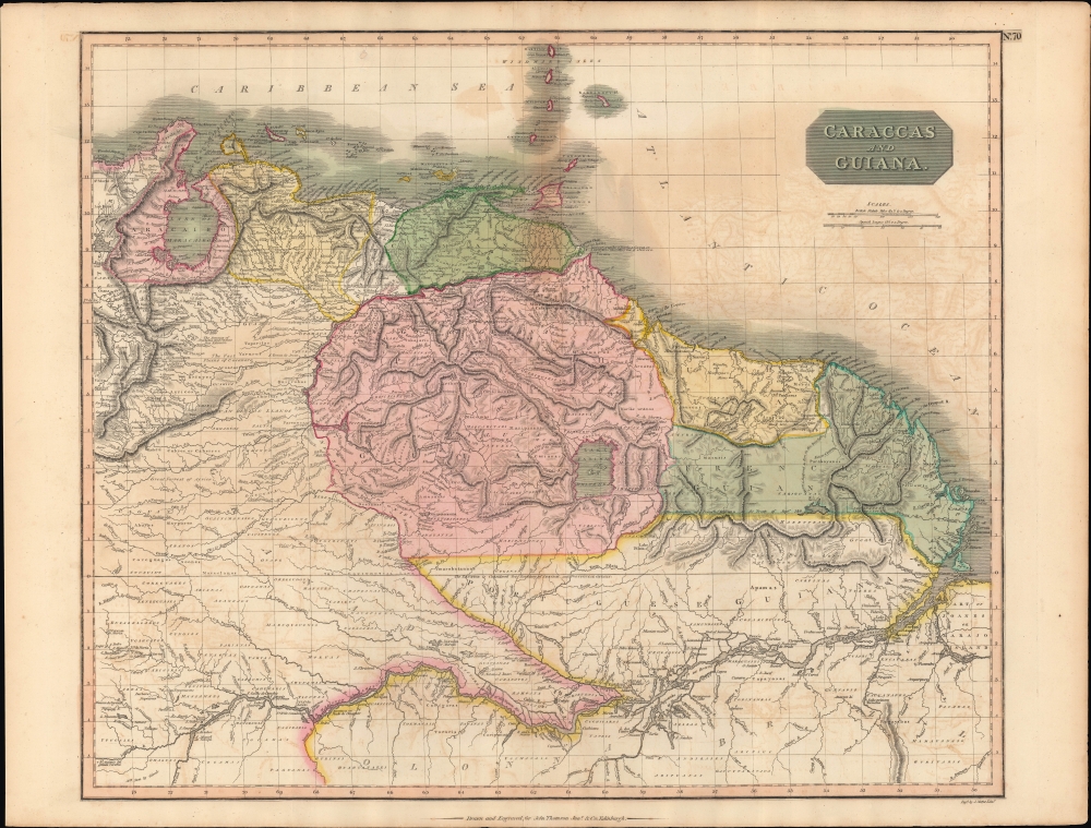
A stunning, highly detailed, and extremely interesting c. 1815 map of northeastern South America, which appeared in the 1817 edition of John Thomson's New General Atlas. It reflects both the limited geographical knowledge of the South American interior as well as the shifting borders following the upheaval of the Venezuelan struggle for independence.
A Closer Look
Coverage includes the modern-day countries and territories of Venezuela, Guyana, French Guyana, Suriname, and parts of Brazil. Relief is shown by hachure with towns, cities, and major topographical features identified. Thomson offers impressive detail throughout, noting indigenous groups, missions, towns and cities, swamps, mountains, and river systems. The upper right-hand quadrant features the title plate and two distance scales, one in British Miles and the other in Spanish Leagues.
Cartographically speaking this is an often-neglected part of the world - especially in the early 19th century. Though the coastlands had been well mapped early in the 16th century, the interior was rarely penetrated. The combination of mountainous terrain, daunting jungles, and malaria made this area all but unexplorable - even today. Nonetheless, Thomson made a commendable attempt to piece together early conquistador accounts, explorer's journals, missionary records, and indigenous reports into a coherent mapping of the area.The Dissolution of Spain's American Empire
This map was prepared as Spain's American empire was under tremendous strain, in large part as a result of the Napoleonic Wars and the French occupation of much of Spain. As elsewhere in the Atlantic World, the ideas of the Enlightenment also laid the groundwork for a desire for new political arrangements. The 1810s were especially chaotic, as Creole elites such as Simon Bolivar soured on the old country and aimed to declare independence. Spain counter-attacked when it could, often winning back territory, if only temporarily, explaining the 'disputed ground' between Caracas and Cumana, as well as the 'New Govrt. of Gumana [Guiana]' south of Cumana.Lake Parima
Another interesting aspect of this map is Thomson's treatment of the apocryphal Lake Parima, located dead center. Lake Parima was first identified by Sir Walter Raleigh in the 16th century - though he admittedly never saw the lake himself. Raleigh associated the lake with indigenous legends of Manoa and the supposed site of El Dorado. Many early maps actually show 'El Dorado' on the shores of Lake Parima, though Thomson curiously does not. However, his rendition of Lake Parima is vastly larger than most previous examples from the late 18th century - even those by other English cartographers such as Laurie and Whittle. The reality of Lake Parima and the Manoa is based upon Raleigh's misinterpretation of local trade networks. The Manoans were a river trading tribe based in the Amazon. Each year during the rainy season flooding on the Orinoco and Parima rivers would create a large flood plain and open channels of trade between the two otherwise unconnected regions. Raleigh misinterpreted indigenous descriptions these watery trade channels as a great lake.Publication History and Census
This map was engraved by J. Moffat of Edinburgh for issue as plate no. 70 in the 1817 edition of Thomson's New General Atlas. In general Thomson maps are known for their stunning color, awe inspiring size, and magnificent detail. Thomson's work, including this map, represents some of the finest cartographic art of the 19th century.
Cartographer
John Thomson (1777 - c. 1841) was a Scottish cartographer, publisher, and bookbinder active in Edinburgh during the early part of the 19th century. Thomson apprenticed under Edinburgh bookbinder Robert Alison. After his apprenticeship he briefly went into business with Abraham Thomson. Later the two parted ways, John Thomson segueing into maps and Abraham Thomson taking over the bookbinding portion of the business. Thomson is generally one of the leading publishers in the Edinburgh school of cartography which flourished from roughly 1800 to 1830. Thomson and his contemporaries (Pinkerton and Cary) redefined European cartography by abandoning typical 18th century decorative elements such as elaborate title cartouches and fantastic beasts in favor of detail and accuracy. Thomson's principle works include Thomson's New General Atlas, published from 1814 to 1821, the New Classical and Historical Atlas of 1829, and his 1830 Atlas of Scotland. The Atlas of Scotland, a work of groundbreaking detail and dedication would eventually bankrupt the Thomson firm in 1830, at which time their plates were sequestered by the court. The firm partially recovered in the subsequent year allowing Thomson to reclaim his printing plates in 1831, but filed again for bankruptcy in 1835, at which time most of his printing plates were sold to A. K. Johnston and Company. There is some suggestion that he continued to work as a bookbinder until 1841. Today, Thomson maps are becoming increasingly rare as they are highly admired for their impressive size, vivid hand coloration, and superb detail. More by this mapmaker...
Source
Thomson, J., A New General Atlas, (Edinburgh: Baldwin, Cradock, Joy) 1817.
Thomson's New General Atlas was first published in 1817 and continued to be published until about 1821. This is the first of Thomson's major cartographic works and the atlas for which is most celebrated. The New General Atlas follows in the Edinburgh School, which eschews excessive decoration in favor of a more minimalistic fact-based cartographic vision, as established by John Pinkerton, Laurie and Whittle, John Cary, and others in the previous decades. The maps are notable for their massive scale, heavy stock, elegant color work, and easy-to-read typefaces. Although the atlas stopped being published after 1821, Thomson continued to offer 'supplementary' maps that could be tipped into the atlas as late as 1830, when he declared bankruptcy. The maps in the Thomson Atlas were engraved by Thomas Clerk, William Dassauville, Nathaniel Rogers Hewitt, James Kirkwood, Robert Kirkwood, John Menzies, George Menzies, Edward Mitchell, John Moffatt, Samuel John Neele, Robert Scott, and James Wyld.
Good. Small area of infill near top border. Light offsetting. Closed margin tears professionally repaired on verso.
Rumsey 1007.076. Phillips (Atlases) 731. Newberry Library: Ayer 135 T4 1817.