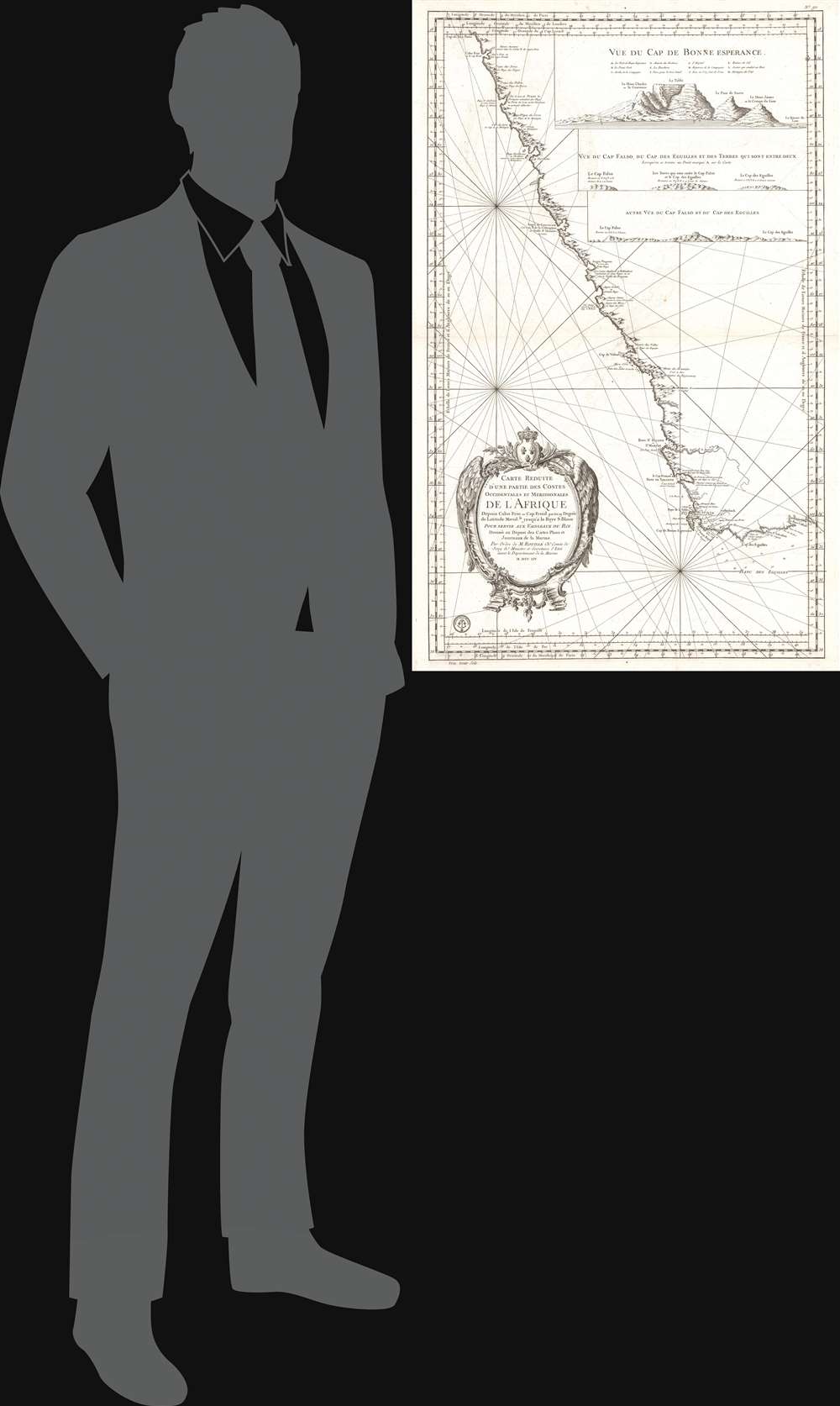
1754 Depot de la Marine Map of the Southwest Coast of Africa
CarteReduiteAfrique-depot-1754$700.00


Title
Carte Reduite d'Une Partie des Costes Occidentales et Meridionales de L'Afrique...
1754 (dated) 36 x 23 in (91.44 x 58.42 cm) 1 : 2646000
1754 (dated) 36 x 23 in (91.44 x 58.42 cm) 1 : 2646000
Description
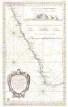
This is the 1754 Jacques Nicolas Bellin nautical map of the southwest coast of Africa and the Cape of Good Hope. The map depicts the region from Cape Fria in Namibia to Cape Agulhas (Cape of the Needles) and the Bay of St. Blaise, including the Cape of Good Hope. Capes, bays, and topographical features including mountains, rivers, and coastal features are illustrated with elevation rendered in profile. Three profile views appear in the top right, 'Vue Du Cap de Bonne Esperance' (Cape of Good Hope), 'Vue Du Cap Falso, Du Cap Des Eguilles et des Terres Qui sont Entre deux' and 'Autre Vue Du Cap Falso et Du Cap Des Eguilles'. Cape Town, Constance (Constantia), Stellenbosch and Hangklip are accurately identified.
This chart Published by the Dépôt des Cartes et Plans de la Marine in 1754. Nine examples of this map are cataloged in OCLC and are part of institutional collections worldwide, including at the National Library of South Africa, Stanford University, the National Maritime Museum in Greenwich, the University of Florida, Duke University, the Universitätsbibliothek Bern, and the Biblioteca Nacional de España.
Publication History and Census
This map was created by Bellin for the French Depot de la Marine. Bellin was commissioned by King Louis XIV to augment and correct earlier nautical charting compiled by the Académie des Sciences. Eventually five variations to this map were created. Bellin’s name is removed from this particular chart. An elaborate and beautiful title cartouche adorned with the arms of the Depot de la Marine is situated in the lower left.This chart Published by the Dépôt des Cartes et Plans de la Marine in 1754. Nine examples of this map are cataloged in OCLC and are part of institutional collections worldwide, including at the National Library of South Africa, Stanford University, the National Maritime Museum in Greenwich, the University of Florida, Duke University, the Universitätsbibliothek Bern, and the Biblioteca Nacional de España.
CartographerS
Dépôt des Cartes et Plans de la Marine (fl. 1720 - present), often called the Dépôt de Marine, was a French hydrographic mapping organization founded in 1720 under Charles-Hercule of Albert de Luynes (1674 - 1734). Much like the U.S. Coast Survey, the British Admiralty, and the Spanish Deposito Hydrografico, the Dépôt was initiated as a storehouse and distribution center of existing nautical and marine charts. Eventually the Dépôt initiated its own mapping activities in an attempt to improve and expand upon existing material. Some of the more prominent cartographers and hydrographers associated with the of Dépôt des Cartes were, Philippe Buache, Jacques-Nicholas Bellin, Giovanni Rizzi-Zannoni, Rigobert Bonne, and Jean Nicolas Buache. More by this mapmaker...
Jacques-Nicolas Bellin (1703 - March 21, 1772) was one of the most important cartographers of the 18th century. With a career spanning some 50 years, Bellin is best understood as geographe de cabinet and transitional mapmaker spanning the gap between 18th and early-19th century cartographic styles. His long career as Hydrographer and Ingénieur Hydrographe at the French Dépôt des cartes et plans de la Marine resulted in hundreds of high quality nautical charts of practically everywhere in the world. A true child of the Enlightenment Era, Bellin's work focuses on function and accuracy tending in the process to be less decorative than the earlier 17th and 18th century cartographic work. Unlike many of his contemporaries, Bellin was always careful to cite his references and his scholarly corpus consists of over 1400 articles on geography prepared for Diderot's Encyclopedie. Bellin, despite his extraordinary success, may not have enjoyed his work, which is described as "long, unpleasant, and hard." In addition to numerous maps and charts published during his lifetime, many of Bellin's maps were updated (or not) and published posthumously. He was succeeded as Ingénieur Hydrographe by his student, also a prolific and influential cartographer, Rigobert Bonne. Learn More...
Condition
Very good. Wear along original centerfold. Verso repair to centerfold separation. Closed margin tears along top margin professionally repaired on verso. Some offsetting and minor foxing. Original platemark visible.
References
Norwich, O. I., Norwich's Maps of Africa: An Illustrated and Annotated Cartobibliography, #279. OCLC 776728872.