1944 Chapin Map of the Battle of Monte Cassino in Italy During World War II
CassinoCorner-chapin-1944$700.00

Title
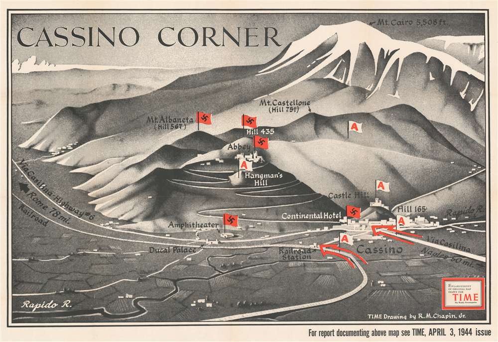
Cassino Corner.
1944 (dated) 29.75 x 43.5 in (75.565 x 110.49 cm)
1944 (dated) 29.75 x 43.5 in (75.565 x 110.49 cm)
Description
Highlighting the bloody campaign to liberate Italy during World War II, this 1944 Robert M. Chapin, Jr. map of Monte Cassino was published before the Battle of Monte Cassino was decided. Monte Cassino was the lynchpin of the Axis Winter Line, a series of defensive lines that stretched across the Italian peninsula from the Adriatic Sea to the Tyrrhenian Sea. Constructed to defend Rome, the Winter Line withstood Allied attacks from December 1943 until June 1944, when it was finally fell in the face of the fourth Allied assault.
The Battle of Monte Cassino and This Map
Published in April 1944, Cassino Corner illustrates the situation between the third and fourth Allied assaults on Cassino and the Winter Line. The three previous assaults, the first of which was fought in conjunction with the Allied amphibious landing at Anzio, were repulsed by the German defenders. The third battle, fought in March 1944, saw fierce combat at Hangman's Hill, and the abbey on top of Monte Cassino. The Allies captured Castle Hill and the railroad station in this third battle, both of which are marked here with what flags emblazoned with a red 'A'. Hangman's Hill, however, though captured by a regiment of the Gurkha Rifles, was abandoned as the position was too exposed. When this map was published, Allied forces were consolidating their lines and reorganizing their forces by pulling exhausted units off the front line and replacing them with rested men. It would not be until mid-May that the Allies would finally break through the Winter Line and push the Germans back, eventually liberating Rome on June 4, 1944.Publication History and Census
This map was created and drawn by Robert M. Chapin, Jr. and published by TIME Magazine in 1944. This example is an enlargement of a map that was published in the April 3, 1944 issue of TIME. The OCLC records examples as being part of the institutional collections at Franklin and Marshall College and the Osher Map Library at the University of Southern Maine.Cartographer
Robert M. Chapin Jr. (fl. 1933 - 1970) was a prominent architect, cartographer and illustrator active during World War II and the Cold War. Chapin graduated from the University of Pennsylvania in 1933 with a degree in architecture. Since this was the height of the Great Depression, and architects in low demand, he instead took work as a staff cartographer at Newsweek. Catching the attention of Manfred Gottfried of Time, Chapin was offered an accepted a position at the head of Time's cartography department. He remained with Time for some 33 years, from 1937 to 1970, often drawn 2 - 3 new thematic maps weekly. With an architect's gift visualizing information, Chapin became a skilled informational cartographer, heading the cartography department at Time Magazine. Chapin, like Fortune Magazine chief cartographer, Richard Edes Harrison, Chapin was at the forefront of infographic propaganda cartography, a genre that matured during the World War II Era and remains popular today. Working for Time Magazine, Chapin developed a signature style for his long run of 'War Maps.' Chapin was known for his maverick airbrush technique which lead to strong color splashes and intense shading. He also incorporated celluloid stencils to illustrate bomb explosions, flags, sinking ships, and more - generating a instantly recognizable standardized style. Chapin's Time war maps were further distinctive for their use of strong bold reds as a universal symbol of hostility. Chapin graduated from the University of Pennsylvania in 1933 with a degree in architecture. Since this was the height of the Great Depression, an d architects in low demand, he instead took work as a staff cartographer at Newsweek. Catching the attention of Manfred Gottfried of Time, Chapin was offered an accepted a position at the head of Time's cartography department. He remained with Time for some 33 years, from 1937 to 1970, often drawn 2 - 3 new thematic maps weekly. Chapin live in Sharon Connecticut. More by this mapmaker...
Condition
Good. Verso repairs to fold separations and at fold intersections. Wear along original fold lines and at fold intersections. Has old institutional collection stamp on verso. We have contacted the institution to verify that this item was legally deaccessioned.
References
OCLC 320454132.