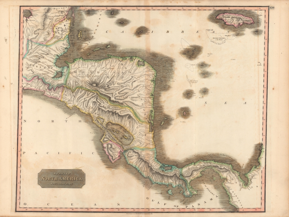
This is John Thomson's beautifully hand-colored 1816 map of Central America, published in 1817 in his New General Atlas. It depicts the region as Spain's colonial empire in the Americas was unraveling as a result of the Napoleonic Wars.
A Closer Look
Central America is displayed from the Laguna de Términos in today's southern Mexico through the Isthmus of Panama to what is now northwestern Colombia. Waterways, mountains, settlements, silver mines, and other features are indicated throughout. An unnamed mountain in Panama is labeled 'both seas [oceans] may be visible from this Mt.' (also true of several other peaks, including the Volcán Barú, here as Varu). The unnamed territory shaded yellow towards top-left was the British trading colony at Belize, an operation of uncertain political and sovereign status. On water, islands, reefs, and hazards are noted in some detail.Historical Context
Though Thomson could not have known it at the time, the map's title proved anachronistic as Spain's American empire was eroding beyond the point of restoration, and the captaincies and other administrative divisions seen here eventually became independent nation-states or regions therein. The dissolution of Spain's American empire was initiated by the Peninsular War and France's occupation of much of Spain. Spanish-descended elites in the Americas were initially motivated by loyalty to their king and country, but over time became increasingly influenced by liberal political ideals. With the end of the Napoleonic Wars, the struggle between a restored yet greatly weakened Spanish monarchy (and its allies in the Americas) and liberals, along with tensions between different regions of Spain's vast American empire, led to repeated wars within and between states, breaking up larger confederations such as Gran Colombia and the United Provinces of the Río de la Plata into nation-states roughly along the borders known to us today.Publication History and Census
This map was engraved in 1816 for issue in the 1817 edition of Thomson's New General Atlas. It is independently cataloged in the holdings of roughly ten institutions, while Thomson's entire atlas is more widely distributed in institutional collections.
Cartographer
John Thomson (1777 - c. 1841) was a Scottish cartographer, publisher, and bookbinder active in Edinburgh during the early part of the 19th century. Thomson apprenticed under Edinburgh bookbinder Robert Alison. After his apprenticeship he briefly went into business with Abraham Thomson. Later the two parted ways, John Thomson segueing into maps and Abraham Thomson taking over the bookbinding portion of the business. Thomson is generally one of the leading publishers in the Edinburgh school of cartography which flourished from roughly 1800 to 1830. Thomson and his contemporaries (Pinkerton and Cary) redefined European cartography by abandoning typical 18th century decorative elements such as elaborate title cartouches and fantastic beasts in favor of detail and accuracy. Thomson's principle works include Thomson's New General Atlas, published from 1814 to 1821, the New Classical and Historical Atlas of 1829, and his 1830 Atlas of Scotland. The Atlas of Scotland, a work of groundbreaking detail and dedication would eventually bankrupt the Thomson firm in 1830, at which time their plates were sequestered by the court. The firm partially recovered in the subsequent year allowing Thomson to reclaim his printing plates in 1831, but filed again for bankruptcy in 1835, at which time most of his printing plates were sold to A. K. Johnston and Company. There is some suggestion that he continued to work as a bookbinder until 1841. Today, Thomson maps are becoming increasingly rare as they are highly admired for their impressive size, vivid hand coloration, and superb detail. More by this mapmaker...
Source
Thomson, J., A New General Atlas, (Edinburgh: Baldwin, Cradock, Joy) 1817.
Thomson's New General Atlas was first published in 1817 and continued to be published until about 1821. This is the first of Thomson's major cartographic works and the atlas for which is most celebrated. The New General Atlas follows in the Edinburgh School, which eschews excessive decoration in favor of a more minimalistic fact-based cartographic vision, as established by John Pinkerton, Laurie and Whittle, John Cary, and others in the previous decades. The maps are notable for their massive scale, heavy stock, elegant color work, and easy-to-read typefaces. Although the atlas stopped being published after 1821, Thomson continued to offer 'supplementary' maps that could be tipped into the atlas as late as 1830, when he declared bankruptcy. The maps in the Thomson Atlas were engraved by Thomas Clerk, William Dassauville, Nathaniel Rogers Hewitt, James Kirkwood, Robert Kirkwood, John Menzies, George Menzies, Edward Mitchell, John Moffatt, Samuel John Neele, Robert Scott, and James Wyld.
Good. Discoloration along fold line and noticeable offsetting. Foxing towards top-right.
Rumsey 1007.065. OCLC 23832194, 54669851, 961941265, 871264041.