This item has been sold, but you can get on the Waitlist to be notified if another example becomes available, or purchase a digital scan.
1832 Marshall Plan or Map of Charleston, South Carolina
Charleston-marshall-1832$150.00

Title
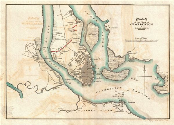
Plan of the Siege of Charleston in S. Carolina.
1832 (undated) 7.5 x 10 in (19.05 x 25.4 cm)
1832 (undated) 7.5 x 10 in (19.05 x 25.4 cm)
Description
This is a rare plan of the Revolutionary War Siege of Charleston, South Carolina, issued for John Marshall's 1832 edition of the Life of Washington. The map covers Charleston Harbor and parts of the Cooper and Ashley Rivers from Sullivan's Island and James Island to the Ship Yard (roughly where Magnolia, St. Lawrence, and Bethany Cemeteries are today). The estates of various important landowners are noted. Color coding indications the positions of British forces as they blockaded both land and sea access to Charleston.
The Siege of Charleston was one of the major battles of the American Revolutionary War. Towards the end of the War, having suffered major losses in the Northern Colonies, the British began to shift their strategic attention towards the American Southern Colonies. After about six weeks of siege, Continental Army Major General Benjamin Lincoln surrendered forces numbering about 5,000 to the British. It was the biggest loss of troops suffered by the Continental Army in the war. The British subsequently remained in control of Charleston until leveraged out by the imminent signing of the Treaty of Paris in 1782.
This map appeared in atlas volume attached to the 1832 edition of John Marshall's seminal work, The Life of Washington. Marshall composed the five volume biography between 1805 and 1807 and based the work on original papers and records provided by the president's own family. The earliest partial edition of the The Life of Washington appeared in 1824 as A History of the American Colonies. In 1832 Marshall revised and abridged the original work voluminous to just two volumes and some 400 pages – from which this map was extracted. The maps of the 1832 edition are notable and desirable in that, unlike the original edition, most had hand applied color work.
CartographerS
John Marshall (September 24, 1755 - July 6, 1835) was the longest-serving Chief Justice of the United States (1801-35). Marshall's court opinions helped establish the basis for American constitutional law and made the Supreme Court of the United States a coequal branch of government along with the legislative and executive branches. Previously, Marshall had been a leader of the Federalist Party in Virginia and served in the United States House of Representatives from 1799 to 1800. He was Secretary of State under President John Adams from 1800 to 1801. Between 1805 and 1807 Marshall published an influential five-volume biography of George Washington. Marshall's Life of Washington was based on records and papers provided to him by the late president's family. The work reflected Marshall's Federalist principles, and is frequently praised by historians for its accuracy and well-reasoned judgments. More by this mapmaker...
Joseph Yeager (1792 - 1859) was a Philadelphia based engraver active in the first half of the 19th century. Yeager was trained early on as an engraver with works appearing as early as 1808 and 1809, at just 16 years of age. By the time he reached adulthood, Yeager had become one of the top engravers in Philadelphia, where he maintained offices from 1816 to 1845. He is responsible for numerous maps and views including the map plates for Carey and Lea's American Atlas and the map plates for the 1832 edition of John Marshall's Life of Washington, and a stunning illustration of the Battle of New Orleans. Yeager also published numerous children's books and, in time, became the president of a railroad. Learn More...
Source
Marshall, J., Atlas to Marshall's Life of Washington, (J. Crissy, Philadelphia) 1832.
Condition
Very good. Offsetting. Original centerfold exhibits light toning. Blank on verso.
References
Rumsey 2559.010 (1807 edition). Howes, W., U.S.iana (1650-1950): A Selective Bibliography in which are Described 11,620 Uncommon and Siginficant Books Relating to the Continental Portion of the United States, M317.