This item has been sold, but you can get on the Waitlist to be notified if another example becomes available, or purchase a digital scan.
1890 Rand McNally Map of Chicago
Chicago-mcnally-1890$150.00

Title
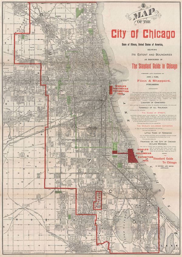
Map of the City of Chicago, State of Illinois, United States of America, showing Its Extent and Boundaries as Described in The Standard Guide to Chicago.
1890 (dated) 27.5 x 19.5 in (69.85 x 49.53 cm)
1890 (dated) 27.5 x 19.5 in (69.85 x 49.53 cm)
Description
A fine decorative map of Chicago issued in 1890 for issue in various editions of the Standard Guide to Chicago. This excellent map covers Chicago from Church Road in the north to Wolf Lane in the south, and from the suburbs of Cicero and Lyons eastward to Lake Michigan. Selected as a railway hub for most of the American Midwest, Chicago was undergoing a boom period and would soon draw the world's attention as the site for the 1893 Chicago World's Fair, or as it is better known the Columbian exposition. The map identifies two competing locations for the fair, Jackson Park, which was ultimately selected, and further north, an undeveloped pier area near the Illinois Central Railroad Docks. The map also illustrates the Chicago Park System. The 'Park System,' designed by Olmsted prodigy William Le Baron Jenny in 1871, refers to a network of parks and garden boulevards intended to embrace the city in arms of foliage. Many of these parks and boulevards remain today. The municipality of Fernwood, at the time an upscale community, is here notably separate from Chicago - it was the last village to be annexed into greater Chicago in 1891, one year after this map was issued. Though this map was issued in all editions of the Standard Guide, it was not updated along with the guide and exists in only one edition.
Cartographer
Rand, McNally and Co. (fl. 1856 - present) is an American publisher of maps, atlases and globes. The company was founded in 1856 when William H. Rand, a native of Quincy, Massachusetts, opened a print shop in Chicago. Rand hired the recent Irish immigrant Andrew McNally to assist in the shop giving him a wage of 9 USD per week. The duo landed several important contracts, including the Tribune's (later renamed the Chicago Tribune) printing operation. In 1872, Rand McNally produced its first map, a railroad guide, using a new cost effective printing technique known as wax process engraving. As Chicago developed as a railway hub, the Rand firm, now incorporated as Rand McNally, began producing a wide array of railroad maps and guides. Over time, the firm expanded into atlases, globes, educational material, and general literature. By embracing the wax engraving process, Rand McNally was able to dominate the map and atlas market, pushing more traditional American lithographic publishers like Colton, Johnson, and Mitchell out of business. Eventually Rand McNally opened an annex office in New York City headed by Caleb S. Hammond, whose name is today synonymous with maps and atlases, and who later started his own map company, C. S. Hammond & Co. Both firms remain in business. More by this mapmaker...
Source
Flinn, J. J., The Standard Guide to Chicago, (Chicago: Flinn & Sheppard) 1892.
Condition
Very good condition. Minor wear on originally fold lines. Professionally flattened and backed with archival tissue.