1858 Marmocchi / Bonatti Map of China
China-marmocchi-1858$250.00
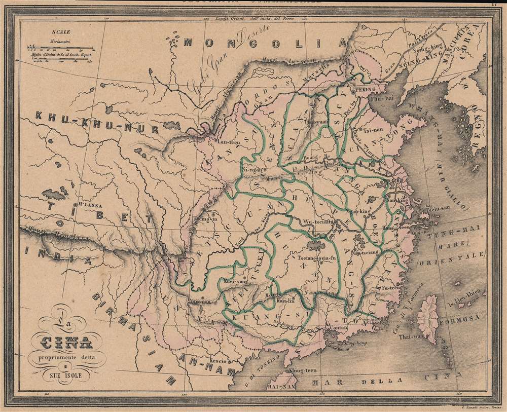

Title
La Cina propriamente della Sue Isole.
1858 (undated) 10.75 x 13 in (27.305 x 33.02 cm) 1 : 11500000
1858 (undated) 10.75 x 13 in (27.305 x 33.02 cm) 1 : 11500000
Description
A rare Italian map of China, produced by Francesco Marmocchi for his 1858 work Il Globo Atlante di Carte Geografiche. It depicts the provinces of 'China proper' along with major geographic features and human-made structures such as the Great Wall.
The individual provinces are outlined in green while the entirety of China proper is outlined in pink. Beyond lie neighboring kingdoms and the other constituent parts of the Qing realm, including Kokonor (Qinghai in Chinese, here as Khu-khu-nor). The Grand Canal and Great Wall of China are indicated, as is the 'Willow Palisade,' a system of ditches and embankments constructed to restrict migration from China proper into Manchuria, as well as prevent migration between Manchu and Mongol regions. However, the Grand Canal, Great Wall, and Willow Palisade had all broken down and ceased to fulfill their intended function by the time this map was published (the Great Wall being superfluous given the Qing alliance with or subordination of the Mongols early in their reign).
Italians have historically had deep connections with China relative to other Europeans, from medieval traders like Marco Polo to the early modern Jesuit missions pioneered by Matteo Ricci and Michele Ruggieri. Some Italian traders were present in Shanghai in the 19th century, especially after the Kingdom of Italy established diplomatic relations with Qing China in 1866, but the Italian commercial presence in China became more pronounced after a dedicated Italian concession was created in Tianjin in 1901. The Catholic Church was a more noticeable mark of the Italian presence in China, especially in rural areas, and of course Italians were the dominant group among the hierarchy of the Holy See, which nominally managed all the Catholic missions in China through the Sacred Congregation for the Propagation of the Faith (Propaganda Fide).
A Closer Look
This map represents 'China proper,' that is, the territory held by the Ming Dynasty that had been conquered by the Manchu Qing Dynasty, which ruled China when this map was made. As the Qing also directly or indirectly ruled lands in Tibet, Central Asia, Mongolia, and their ancestral Manchuria, this distinction was culturally significant and administratively useful.The individual provinces are outlined in green while the entirety of China proper is outlined in pink. Beyond lie neighboring kingdoms and the other constituent parts of the Qing realm, including Kokonor (Qinghai in Chinese, here as Khu-khu-nor). The Grand Canal and Great Wall of China are indicated, as is the 'Willow Palisade,' a system of ditches and embankments constructed to restrict migration from China proper into Manchuria, as well as prevent migration between Manchu and Mongol regions. However, the Grand Canal, Great Wall, and Willow Palisade had all broken down and ceased to fulfill their intended function by the time this map was published (the Great Wall being superfluous given the Qing alliance with or subordination of the Mongols early in their reign).
Italians in Qing China
When this map was published, the Qing were near their nadir. Not only had they lost the Opium War to the British, but they were also facing a new conflict with the British and French over opium and other outstanding issues around trade and foreigners residing in the newly created treaty ports like Shanghai (here as Sciang-hai). Even worse, a massive rebellion in southern China declared a competing dynasty, the Taiping Heavenly Kingdom, and had taken major cities along the Yangzi River, like Nanjing, Suzhou, and Hangzhou, though the Qing managed to repel them outside of Shanghai (ironically, with British and French help). Several other rebellions also broke out elsewhere in China, and the Qing just barely managed to survive by devolving authority to provincial governors and relying on assistance from the same foreign powers that sought to exploit China's vast resources and domestic market.Italians have historically had deep connections with China relative to other Europeans, from medieval traders like Marco Polo to the early modern Jesuit missions pioneered by Matteo Ricci and Michele Ruggieri. Some Italian traders were present in Shanghai in the 19th century, especially after the Kingdom of Italy established diplomatic relations with Qing China in 1866, but the Italian commercial presence in China became more pronounced after a dedicated Italian concession was created in Tianjin in 1901. The Catholic Church was a more noticeable mark of the Italian presence in China, especially in rural areas, and of course Italians were the dominant group among the hierarchy of the Holy See, which nominally managed all the Catholic missions in China through the Sacred Congregation for the Propagation of the Faith (Propaganda Fide).
Publication History and Census
This map appeared as Plate 17 in Francesco Marmocchi's Il Globo Atlante di Carte Geografiche, published in 1858, the year of Marmocchi's death. The maps in the atlas retained the title of his earlier work 'Geografia Commerciale' on their plates, and the margin may have been cut close to obscure the title and avoid confusion. It was engraved by G. Bonatti of Turin and published by Paolo Rivara in Genoa. It is only cataloged among the holdings of Ajman University and is scarce to the market, while the entire atlas is held by the David Rumsey Historical Map Collection, the Newberry Library, and the National Library of Australia.Cartographer
Francesco Costantino Marmocchi (August 26, 1805 - September 9, 1858) was an Italian geographer. Following in the footsteps of his father, a professor of physics, he began his studies in the natural sciences. He became involved in the Italian nationalist movement and was an associate of Guiseppi Mazzini, leading to his being arrested and briefly imprisoned before being put under house arrest in his hometown of Poggibonsi. He tried to move to Naples under a pseudonym, but was discovered and was forced to leave, settling in Rome. He then focused on publishing, producing translations, original works, and managing a popular broadsheet dedicated to scientific discoveries. More by this mapmaker...
Source
Marmocchi, Francesco C., Il Globo Atlante di Carte Geografiche, (Paolo Rivara: Genoa) 1858.
Condition
Good. Margin trimmed closely. Even toning. Light foxing.
References
Rumsey 12235.018.