1904 Commercial Intelligence Map of China
China-sell-1904$850.00
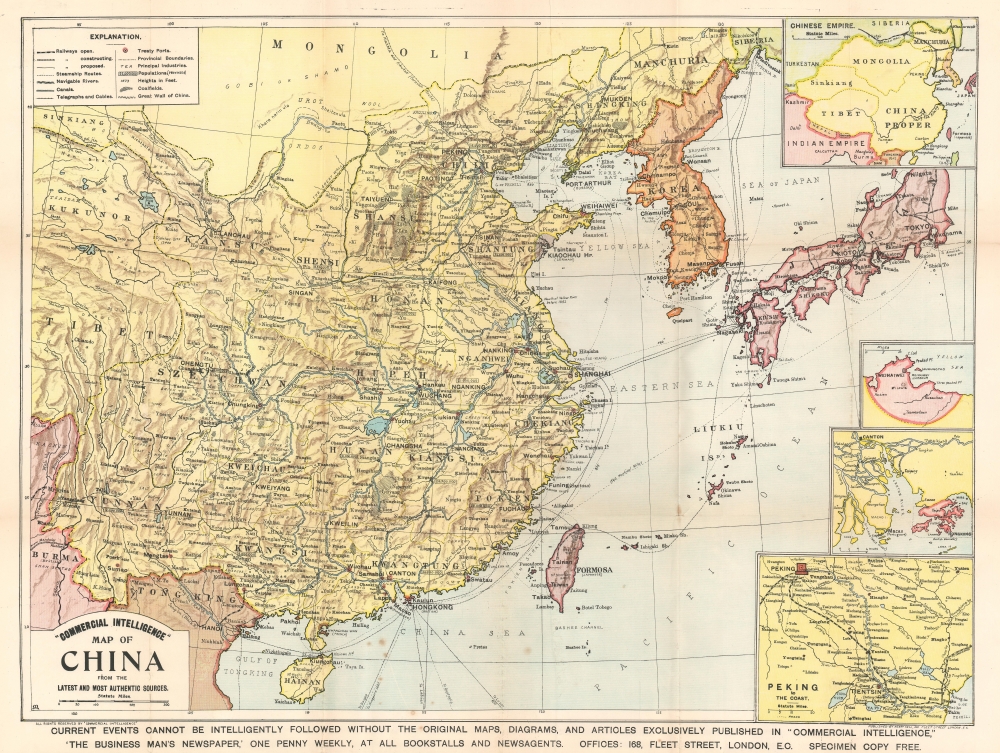

Title
Commercial Intelligence' Map of China from the Latest and Most Authentic Sources.
1904 (undated) 21.5 x 28.5 in (54.61 x 72.39 cm) 1 : 6336000
1904 (undated) 21.5 x 28.5 in (54.61 x 72.39 cm) 1 : 6336000
Description
This is a 1904 Henry Sell map of China during the Russo-Japanese War published in 'Commercial Intelligence'. Sell published the map to capitalize on interest in the Russo-Japanese War (1904 - 1905). He nonetheless also included information appealing to his business-minded readers, including data on major cities and transportation networks.
There was initially some attempt at negotiation between the imperialist powers, but Tsar Nicholas II arrogantly believed it impossible that Japan could challenge a major European power. Japan proved him wrong, launching a surprise attack on the Russian Eastern Fleet stationed at Port Arthur. Throughout the course of the war, the Russians were defeated again and again, humiliating the Tsar and forcing U.S. President Theodore Roosevelt to arbitrate a peace, confirmed by the Treaty of Portsmouth. The treaty recognized Japan's claims on Korea and called for the evacuation of Russian forces from Manchuria, including from Port Arthur.
The overwhelming victory of Imperial Japan came as a surprise to international observers, being the first major military victory in the modern era of an Asian over European power. The consequences transformed the balance of power, confirmed Japan as the pre-eminent power in East Asia.
A Closer Look
The large central map provides a detailed view of the region, with cities, towns and villages identified throughout eastern and central China, while only major cities are noted in Korea and Japan. The railroad network, of particular interest to business-minded readers, is highlighted. The railroad connecting Beijing (Peking) and Tianjin (Tientsin) is illustrated, along with the Manchurian railway from Port Arthur that was currently being built by the Russians. Railways under construction, and even proposed railways, are also noted. Japan's burgeoning railway network is detailed as well, and the railway from Vladivostok in Russia is just visible on the upper right. An inset map in the upper right corner of entitled 'Chinese Empire' focuses heavily on the railways in Manchuria, since only the railways and the Yangtse River are noted among the labeled nations. Trade routes between nations, and undersea telegraphs and cables are also illustrated, connecting Shanghai with Nagasaki, Shanghai and Hong Kong, and Nagasaki and Vladivostok.The Insets in the Lower Right Corner
Three inset maps, each of which would have been of interest to the British reader, are situated in the lower right. The first depicts the region surrounding Weihaiwai (Weihaiwei), the site of the first major battle of the First Sino-Japanese War. Japan defeated the Chinese Navy, won the battle, and seized Weihaiwai, securing a foothold on the Shandong Peninsula. British military advisors served with the Chinese fleet during the battle, and, in the end, surrendered what was left of the fleet to the Japanese after both Chinese commanders committed suicide. The second highlights Hong Kong, a British possession seized during the First Opium War. This inset situates Hong Kong with relation to Guangzhou (Canton), the only port open to foreign trade until after the First Opium War. The third presents the completed railway network between Beijing (Peking) and Tianjin (Tientsin) in greater detail that was possible in the larger maps.The Russo-Japanese War
As stated above, this map was published just prior to the outbreak of the Russo-Japanese War. The Russo-Japanese War, fought from February 8, 1904 - September 5, 1905, pitted Imperial Japan against Tsarist Russia over rival imperial ambitions in Manchuria and Korea. Both Russia and Japan had grand visions for the region. Russia traditionally had only one Pacific port, Vladivostok, which was operational only during the warm summer months. In 1898, Russia coerced China, then weakened after the First Sino-Japanese War (1894 - 1895), to lease Port Arthur, a warm water port on the Liaodang Peninsula. They also negotiated a right-of-way to connect Port Arthur to the China Eastern Railway, which ran from nearby Dalian (Dalny) to Harbin, a stop on the Siberian Railway. Russia, eager to expand southwards from Siberia, considered Port Arthur the cornerstone of a sphere of influence covering China, Manchuria, and Korea. Japan had its own Imperial ambitions and saw itself as the natural overlord in East Asia. Korea and Manchuria in particular were important as steppingstones into China, with its seemly unlimited resources.There was initially some attempt at negotiation between the imperialist powers, but Tsar Nicholas II arrogantly believed it impossible that Japan could challenge a major European power. Japan proved him wrong, launching a surprise attack on the Russian Eastern Fleet stationed at Port Arthur. Throughout the course of the war, the Russians were defeated again and again, humiliating the Tsar and forcing U.S. President Theodore Roosevelt to arbitrate a peace, confirmed by the Treaty of Portsmouth. The treaty recognized Japan's claims on Korea and called for the evacuation of Russian forces from Manchuria, including from Port Arthur.
The overwhelming victory of Imperial Japan came as a surprise to international observers, being the first major military victory in the modern era of an Asian over European power. The consequences transformed the balance of power, confirmed Japan as the pre-eminent power in East Asia.
Publication History and Census
This map was published by Henry Sell in his weekly 'Commercial Intelligence'. Only one example is cataloged in the OCLC, and it is part of the collection at the British Library.Cartographer
Henry Sell (fl. c. 1880 - c. 1910) was a publisher active in London during the late 19th and early 20th century. He published the weekly newspaper entitled 'Commercial Intelligence' that was marketed toward business-minded individuals. More by this mapmaker...
Condition
Good. Exhibits toning. Verso repairs at fold intersections. Attached to original binder.
References
OCLC 556898719.