1720 Chatelain Chart of Historical Empires and Nations Before the Common Era
ChronologieEtatsEmpires-chatelain-1720$350.00

Title
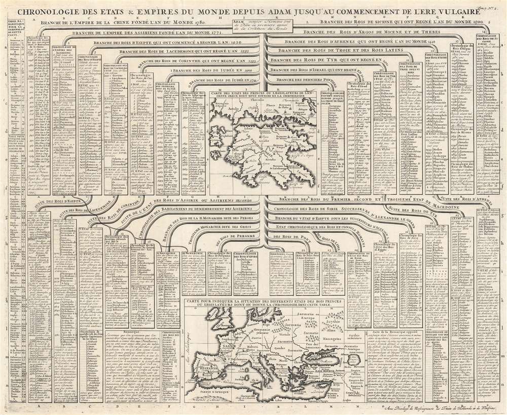
Chronologie des Etats et Empires du Monde depuis Adam Jusqu'au Commencement de l'Ere Vulgaire.
1720 (undated) 19.625 x 24 in (49.8475 x 60.96 cm)
1720 (undated) 19.625 x 24 in (49.8475 x 60.96 cm)
Description
This is a 1720 Henri Abraham Chatelain chart of historical empires and nations before the Common Era. The chart chronicles thousands of years of human history and separates nations and empires into columns. Among the histories recounted are those of Rome, Egypt, China, Sparta (Lacedemone), Athens, Corinth, Judea, and Persia. Two maps accompany the chart, with one focusing on the Peloponnesus and southern Greece and the other on Europe, the Mediterranean, and the Middle East. In a short description, Chatelain explains that they used the year 4000 to represent the year of the birth of Jesus Christ, allowing viewers to better understand how the numbers next to each ruler's name provide a chronological understanding of events.
L'Ère Vulgaire
L'Ère Vulgaire is a phrase adopted to identify the era following the birth of Jesus Christ without referencing Christianity or any other religion. The phrase originated in Latin, aerae vulgaris. Vulgaris comes from vulgus, which means 'the common people' and was meant to avoid the regnal year, or the year of the reign of a sovereign. It had no derogatory meaning. The earliest known use of the Latin phrase dates from 1615 in a book by Johannes Kepler. The earliest English usage dates from 1635 in a translation of Kepler's book.Publication History and Census
This chart was published by Henri Abraham Chatelain and François L'Honoré in 1720 in the seventh volume of their Atlas historique, ou Nouvelle introduction à l'histoire, à la chronologie et à la géographie ancienne et moderne... titled Suplément a l'Atlas Historique contenant diverses pièces de Chronologie, de Genealogie, d'Historie, et d'autres Science qui avoient été omises dans les précédens Volumes. We note two cataloged examples of the separate chart in OCLC: Bayerische Staatsbibliothek and the Staatliche Bibliothek Regensburg. The Suplément a l'Atlas Historique is well represented in institutional collections.Cartographer
Henri Abraham Chatelain (1684 - 1743) was a Huguenot pastor of Parisian origins. He lived consecutively in Paris, St. Martins, London (c. 1710), The Hague (c. 1721) and Amsterdam (c. 1728). He is best known as a Dutch cartographer and more specifically for his cartographic contribution in the seminal seven volume Atlas Historique, published in Amsterdam between 1705 and 1720. Innovative for its time, the Atlas Historique combined fine engraving and artwork with scholarly studies of geography, history, ethnology, heraldry, and cosmography. Some scholarship suggests that the Atlas Historique was not exclusively compiled by Henri Chatelain, as is commonly believed, but rather was a family enterprise involving Henri, his father Zacharie and his brother, also Zacharie. More by this mapmaker...
Source
Chatelain, H., Atlas historique, ou Nouvelle introduction à l'histoire, à la chronologie et à la géographie ancienne et moderne, (Amsterdam: Chatelain) 1720.
Condition
Very good. Light wear along original fold lines.
References
OCLC 164794519.