This item has been sold, but you can get on the Waitlist to be notified if another example becomes available, or purchase a digital scan.
1898 Stewart / Earnshaw Map of Cincinnati, Ohio and Vicinity
Cincinnati-stewart-1898$250.00


Title
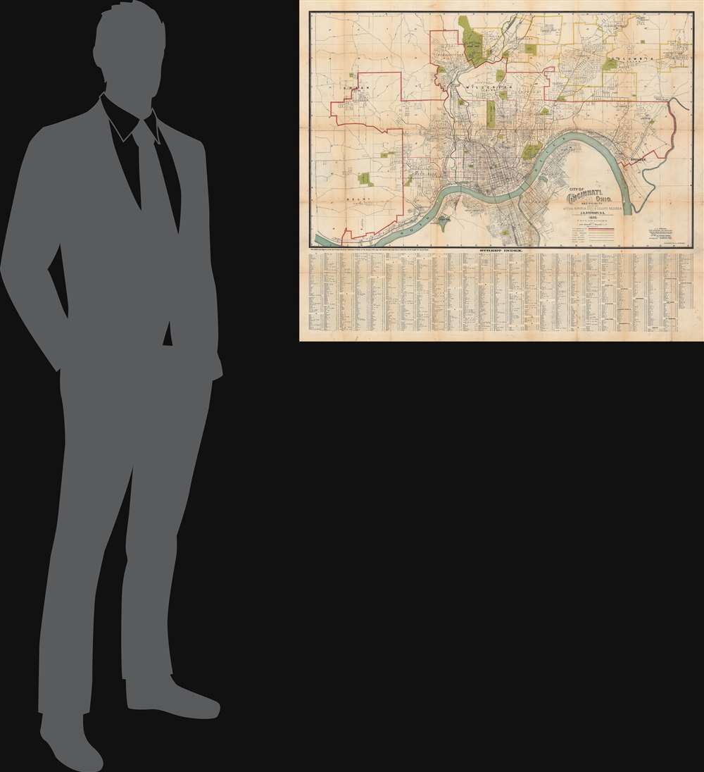
City of Cincinnati, Ohio and Vicinity.
1898 (dated) 22 x 35.75 in (55.88 x 90.805 cm) 1 : 24000
1898 (dated) 22 x 35.75 in (55.88 x 90.805 cm) 1 : 24000
Description
This is a rare 1898 folding map of Cincinnati, Ohio by J. A. Stewart and C. S. Earnshaw. It shows the city during a period of breakneck growth, when it developed into a major transit hub on the Ohio River.
Cincinnati's location on the Ohio River made it a good transit point for agricultural resources produced nearby (including Kentucky and Indiana), and the city attracted Irish and German immigrants in large numbers in the mid-19th century. Between 1850 and 1900, the city's population nearly tripled to over 300,000. Due to its proximity to Kentucky, Cincinnati also played an important role on the Underground Railroad (a museum dedicated to it was opened in 2004 at 2nd St. and Vine St., in section M14 according to the grid here). During the Civil War, Cincinnati was a major Union supply center.
Despite its continued economic development, Cincinnati was also extremely tense due to political corruption and poor labor conditions. It also developed a reputation for violent crime. The result was the Courthouse Riots in 1884, one of the most violent riots in U.S. history, resulting from what was widely seen to be an overly-lenient sentence of an accused murderer. Localized unrest around the courthouse and jail spiraled out of control when several waves of Ohio militia were sent in to quell the unrest, eventually using heavy-handed tactics to pacify the rioters.
A Closer Look
The sheet is divided between the map itself and an extensive index at bottom, listing the streets of Cincinnati as well as nearby suburbs. The city is also divided into 31 wards, outlined in red, while borders between townships and villages are indicated in suburban areas. Several bridges across the Ohio River are shown, including the John A. Roebling suspension bridge built in the 1860s as a prototype for the larger Brooklyn Bridge.Historical Context
Cincinnati was founded in the 1790s at the confluence of the Ohio and Licking Rivers. The city's early development was aided by the adoption of steamboats, and later by canals and railroads (the density of rail lines, especially on the city's west side, is apparent here). In 1880, in a highly unusual move, the city financed a railroad to Chattanooga, Tennessee (now part of the Cincinnati, New Orleans and Texas Pacific Railway). Streetcar lines developed in the closing decades of the 19th century and were electrified in the years before this map's publication. In the early 20th century, Cincinnati began building a subway system, using the unutilized Miami and Erie Canal as a basis. Though the line was partially constructed, including four stations, financial setbacks caused by World War I, Prohibition, and the Great Depression meant it was never completed or opened to the public.Cincinnati's location on the Ohio River made it a good transit point for agricultural resources produced nearby (including Kentucky and Indiana), and the city attracted Irish and German immigrants in large numbers in the mid-19th century. Between 1850 and 1900, the city's population nearly tripled to over 300,000. Due to its proximity to Kentucky, Cincinnati also played an important role on the Underground Railroad (a museum dedicated to it was opened in 2004 at 2nd St. and Vine St., in section M14 according to the grid here). During the Civil War, Cincinnati was a major Union supply center.
Despite its continued economic development, Cincinnati was also extremely tense due to political corruption and poor labor conditions. It also developed a reputation for violent crime. The result was the Courthouse Riots in 1884, one of the most violent riots in U.S. history, resulting from what was widely seen to be an overly-lenient sentence of an accused murderer. Localized unrest around the courthouse and jail spiraled out of control when several waves of Ohio militia were sent in to quell the unrest, eventually using heavy-handed tactics to pacify the rioters.
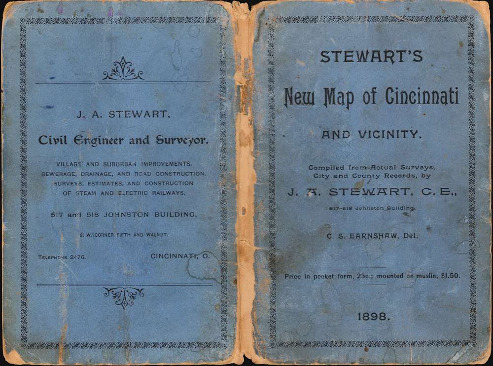
Publication History and Census
This map was drawn by C. S. Earnshaw in 1898 and it is attributed to J. A. Stewart, civil engineer (little information is available about either individual). Only four institutions are known to hold this map and it has no known history on the market.Condition
Good. Wear and toning along fold lines and at fold intersections. Sporadic spots of discoloration.
References
OCLC 55210431, 40803084.