Digital Image: 1932 Maw Pictorial Map of the City of Quebec, Canada
CityOfQuebec-maw-1932_d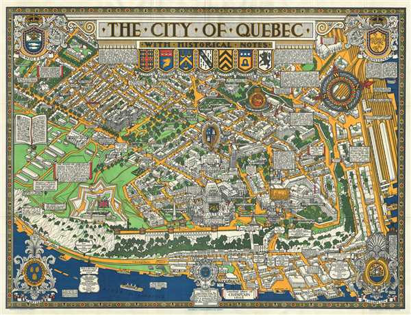

Title
The City of Quebec with Historical Notes.
1932 (dated) 27 x 35 in (68.58 x 88.9 cm)
1932 (dated) 27 x 35 in (68.58 x 88.9 cm)
Description
FOR THE ORIGINAL ANTIQUE MAP, WITH HISTORICAL ANALYSIS, CLICK HERE.
Digital Map Information
Geographicus maintains an archive of high-resolution rare map scans. We scan our maps at 300 DPI or higher, with newer images being 600 DPI, (either TIFF or JPEG, depending on when the scan was done) which is most cases in suitable for enlargement and printing.
Delivery
Once you purchase our digital scan service, you will receive a download link via email - usually within seconds. Digital orders are delivered as ZIP files, an industry standard file compression protocol that any computer should be able to unpack. Some of our files are very large, and can take some time to download. Most files are saved into your computer's 'Downloads' folder. All delivery is electronic. No physical product is shipped.
Credit and Scope of Use
You can use your digial image any way you want! Our digital images are unrestricted by copyright and can be used, modified, and published freely. The textual description that accompanies the original antique map is not included in the sale of digital images and remains protected by copyright. That said, we put significant care and effort into scanning and editing these maps, and we’d appreciate a credit when possible. Should you wish to credit us, please use the following credit line:
Courtesy of Geographicus Rare Antique Maps (https://www.geographicus.com).
How Large Can I Print?
In general, at 300 DPI, you should at least be able to double the size of the actual image, more so with our 600 DPI images. So, if the original was 10 x 12 inches, you can print at 20 x 24 inches, without quality loss. If your display requirements can accommodate some loss in image quality, you can make it even larger. That being said, no quality of scan will allow you to blow up at 10 x 12 inch map to wall size without significant quality loss. For more information, it is best consult a printer or reprographics specialist.
Refunds
If the high resolution image you ordered is unavailable, we will fully refund your purchase. Otherwise, digital images scans are a service, not a tangible product, and cannot be returned or refunded once the download link is used.
Cartographer
Samuel Herbert Maw (September 12, 1881-1952) was a English engineer, architect, photographer artist, and graphic designer active in Quebec during the first half of the 20th century. Maw was born in England where he attended the Ackworth School. Although not formally trained as an architect, he apprenticed with John. S. Dorden of Ipswich and Edward W. Mountfort, of London. From about 1904 on he worked as a draftsman with the London firm of Bradshaw, Gass and Bolton. In 1912 Maw emigrated to the United States where he became a partner in the firm of Brown and Maw. This must not have worked out, because he relocated to Toronto later in the same year, taking a position with the firm of Darling and Pearson. Maw moved from firm to firm within Canada, briefly working in Toronto, Montreal, Ottawa, and Halifax. During World War II, Maw was assigned to the Engineering and Maintenance Branch of the Naval Service Department in Ottawa. He produced pictorial maps of Quebec City (1932), Montreal, Ottawa (1944), and the Gaspé Peninsula (1929). When Maw died he was working on a similar map of Halifax, but it is unclear if it was ever completed or published. More by this mapmaker...
References
Rumsey 7978.000.