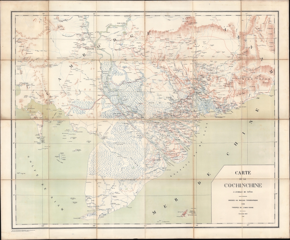
1889 French Bureau Topographique Map of South Vietnam and Cambodia
Cochinchine-bureautopographique-1889$950.00


Title
Carte de la Cochinchine.
1889 (dated) 36 x 44 in (91.44 x 111.76 cm) 1 : 500000
1889 (dated) 36 x 44 in (91.44 x 111.76 cm) 1 : 500000
Description
This is an 1889 Bureau topographique des Troupes de l'Indochine map of Cochinchina, including parts of modern-day southern Vietnam and Cambodia. The map is significant for its coverage of the Saigon - Mỹ Tho Railroad and Vĩnh Tế Canal.
Even when construction was completed and problems with the bridges were solved, the company organized to operate the railway could not turn a profit, due partially to Chinese rice merchants preferring barge transport. This led colonial authorities to suspend the Maison Eiffel franchise and operations over to Saigon's steam tramway (which only agreed to operate it if the colonial government would be responsible for maintaining and repairing the line). In 1912, with the line still unprofitable, the colonial government again terminated the franchise, and the line was taken over fully by the colonial government. By the 1930s, the burgeoning road network began to seriously compete with the Saigon - Mỹ Tho line. The French military used the line during the First Indochina War (1946 - 1954) to move troops and supplies, making the rails targets for the Việt Minh. After the war, the South Vietnamese Department of Railways took over. By this time, the road network had significantly expanded, limiting the railroad's value and leading to its closing on June 30, 1958.
A Closer Look
Coverage extends from the Tamboun River south to the Cà Mau Peninsula, thus embracing the important Phnom Penh - Saigon corridor. Both the important Saigon - Mỹ Tho Railroad (French Indochina's first railroad) and the Vĩnh Tế Canal are illustrated. Red lines detail Cochinchina's road network and likely differentiate different road grades or stages of construction. The Mekong Delta is illustrated in detail and is labeled Bouches du Me Kong.The Saigon - Mỹ Tho Railroad Line
Construction began on the Saigon - Mỹ Tho Railroad line in November 1882. The line had originally been part of a planned Mekong Delta railway network that never materialized. The Saigon - Mỹ Tho line suffered from construction woes from the outset. The Maison Eiffel, one of the sub-contractors, did not account for the marshy terrain, which caused the three major tracks to slowly sink. Nonetheless, the railway officially opened on July 20, 1885, but did not run through service until May 29, 1886, because continuing problems with the Bền Lức Bridge forced the railway to use a ferry to cross the East Vàm Cỏ River. The builders also elected to use the same 20kg/m rails as the Saigon steam tramway, which limited the railway to lightweight rolling stock.Even when construction was completed and problems with the bridges were solved, the company organized to operate the railway could not turn a profit, due partially to Chinese rice merchants preferring barge transport. This led colonial authorities to suspend the Maison Eiffel franchise and operations over to Saigon's steam tramway (which only agreed to operate it if the colonial government would be responsible for maintaining and repairing the line). In 1912, with the line still unprofitable, the colonial government again terminated the franchise, and the line was taken over fully by the colonial government. By the 1930s, the burgeoning road network began to seriously compete with the Saigon - Mỹ Tho line. The French military used the line during the First Indochina War (1946 - 1954) to move troops and supplies, making the rails targets for the Việt Minh. After the war, the South Vietnamese Department of Railways took over. By this time, the road network had significantly expanded, limiting the railroad's value and leading to its closing on June 30, 1958.
The Vĩnh Tế Canal
The Vĩnh Tế is a 54-mile-long (87 kilometers) canal in southern Vietnam built between 1819 and 1824. Around 80,000 local Vietnamese and Khmer workers built it under Emperors Gia Long and Minh Mang. Thousands of workers died of fatigue and disease, and several Khmer-led rebellions ignited during the 5 years of construction. Khmer workers suffered other abuses at the hands of Vietnamese workers (according to Cambodian nationalists), resulting in the Vĩnh Tế Canal becoming part of the anti-Vietnamese propaganda embraced by the Khmer Rouge over a century later.Publication History and Census
This map was drawn by Jean Baptiste Laurent Friquegnon (August 10, 1858 - 1934) and published by the Bureau Topographique des Troupes de l'Indochine in 1889. We note two cataloged examples in OCLC, at the Bibliothèque Nationale de France and the Bibliothèque Nationale Universitaire de Strasbourg.CartographerS
Bureau Topographique des Troupes de l'Indo-chine (fl. c. 1886 - 1900) was founded in 1886 in Hanoi. Its first major project was a 1:2000000 map of the entirety of Indochina, for which they drew on source maps created by the Service Hydrographique de la Marine and those created by an expeditionary corps sent throughout the region. Before establishing its own printing facilities in Indochina in 1890, the Bureau Topographique transferred their work back to Paris to be printed by the Service Géographique de l'Armée. In 1890 the Bureau Topographique also began to increase its cartographic output. The Bureau Topographique sent army officers on triangulation and topographic missions in unexplored areas of Indochina throughout the 1890s, some of which proved fatal for the participants. It is unclear when the Bureau Topographique shut down, but no examples of their work postdate 1900. More by this mapmaker...
Jean Baptiste Laurent Friquegnon (August 10, 1858 - 1934) was a French geographer and military officer. Born in Valleroy, France, Friquegnon entered the military on March 1, 1877. He was promoted to sous-lieutenant d'Infanterie de Marine on March 19, 1883. By January 1885 he was serving in Tonkin in French Indochina as a member of the Tirailleurs tonkinois. Friquegnon was gravely wounded on an expedition to Kem that year, he was promoted to lieutenant and named a Chevalier of the Legion of Honor. In 1889 he was appointed to the service topographique de l'état-major d'Hanoï, and subsequently became a member of the Pavie expedition to Laos, led by Auguste Jean-Marie Pavie (May 31, 1847 - June 7, 1925). He was one of Pavie's photographers on this expedition and took numerous photographs during this expedition and the two subsequent expeditions. Friquegnon returned to France in 1892 to command the 8th Marine Regiment at Toulon. He returned to Tonkin two years later. In 1896, back in France, he worked at the Ministry of Foreign Affairs to help produce a new edition of a map of Indochina. He left for Tonkin again in 1903, and in 1904 he was made the director of the service géographique de l'Indochine and promoted to lieutenant colonel. After another series of postings in France, he returned to Cochinchine in 1913 and took command of the Tirailleurs annamites which he led in combat against the Chinese in Laos. In 1916 he returned to France and was put in command of the training center at Cavaillon the following year. In 1919 he was made the regional commander of colonial workers in Lille. He was made an Officier de la Légion d'Honneur on December 30, 1905 and a Commandeur de la Légion d'Honneur on October 5, 1916. Over the course of his career, Friquegnon made at least fifteen maps of Southeast Asia, some of which were produced for the Pavie expeditions. He married Lucie Picanon on November 5, 1895, and then remarried on July 4, 1903, to Antoinette Alice Rebel. Learn More...
Condition
Very good. Dissected and mounted on linen in 32 panels.
References
OCLC 903599332, 494840190.