This item has been sold, but you can get on the Waitlist to be notified if another example becomes available, or purchase a digital scan.
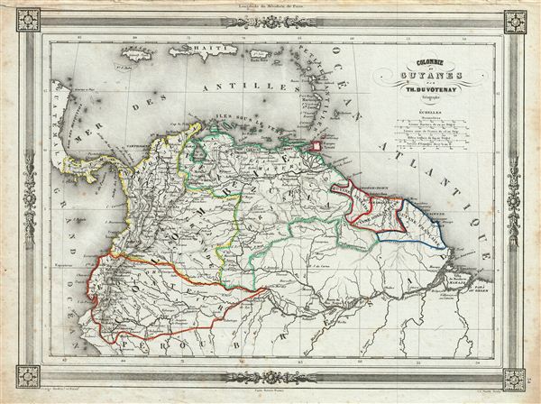
1852 Duvotenay Map of Colombia and Guyana
ColombiaGuyana-duvotenay-1852$75.00

Title
Colombie et Guyanes.
1852 (undated) 10 x 13 in (25.4 x 33.02 cm)
1852 (undated) 10 x 13 in (25.4 x 33.02 cm)
Description
An uncommon and extremely attractive 1852 map of Colombia and Guyana. The map covers Gran Colombia (modern day Colombia, Venezuela, ecuador, Panama, northern Peru and northwest Brazil) and the British, Dutch and French Guyana from the Caribbean Sea in the north to Peru and Brazil in the south. Throughout, the map identifies various cities, towns, rivers and assortment of additional topographical details. Venezuela and ecuador, in 1829 and 1839 respectively, became independent states and Simon Bolivar's vision of Gran Columbia was proven untenable. However, a period of political upheaval and civil war would follow in the region. Venezuela dissolved in the bloody Federal War (1859-1863) in which a significant percentage of the population perished. Colombia was then under the Confederación Granadina, a short lived federal republic that consisted of modern day Colombia and Panama. The Confederación, facing strong opposition from both liberal and conservative elements, dissolved in 1863 in the midst of the Colombian Civil War (1860 – 1862). The map features a beautiful frame style border. Prepared by Th. Duvotenay for publication as plate no. 34 in Maison Basset's 1852 edition of Atlas Illustre Destine a l'enseignement de la Geographie elementaire.
CartographerS
Thunot Duvotenay (1796 - 1875) was a French geographer active in the mid 19th century. Thunot is known to have worked with several other important cartographers of his dayincluding Barbie du Bocage, Vuillemin, Charle, Levassseur and Dufour. More by this mapmaker...
Jean Denis Barbie du Bocage (1760 - 1825) and his son Jean-Guillaume Barbie du Bocage (1795 - 1848) were French cartographers and cosmographers active in Paris during late 18th and early 19th centuries. The elder Barbie du Bocage, Jean Denis, was trained as a cartographer and engraver in the workshops of mapmaking legend J. B. B. d'Anville. At some point Jean Denis held the post of Royal Librarian of France and it was through is associations with d'Anville that the d'Anville collection of nearly 9000 maps was acquired by French Ministry of Foreign Affairs. The younger Barbie du Bocage, Jean-Guillaume, acquired a position shortly afterwards at the Ministry of Foreign Affairs and, in time, became its head, with the title of Geographe du Ministere des Affaires Etrangeres. Learn More...
Source
Barbie du Bocage, J. D., Atlas Illustre Destine a l'Enseignement de la Geographie Elementaire, (Paris: Maison Basset) 1852.
Condition
Very good. Blank on verso. Minor foxing throughout.