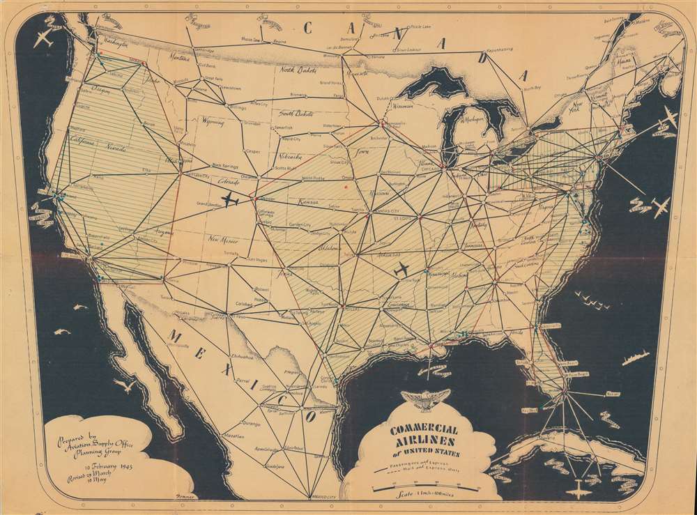
1945 Aviation Supply Office Map of United States Commercial Airline Routes
CommercialAirlines-sommer-1945$550.00

Title
Commercial Airlines of United States.
1945 (dated) 24.25 x 33 in (61.595 x 83.82 cm) 1 : 633600
1945 (dated) 24.25 x 33 in (61.595 x 83.82 cm) 1 : 633600
Description
This is a 1945 Aviation Supply Office Planning Group map of the United States showing airline routes. The pictorial map illustrates a little-known but significant element of the American mobilization for World War II (1939 - 1945) - the nationalization and utilization of commercial aircraft to support the war effort.
The Aviation Supply Office and Commercial Airlines during World War II
When the United States entered World War II, it had only a small standing army. The subsequent national mobilization led to extreme shortfalls in military equipment and infrastructure. The Army Air Corps (Air Force after the war) desperately needed planes to transport troops and supplies. They thus nationalized a portion of all domestic commercial air fleets. Military officials 'convinced' airlines to 'do their part' by air-freighting tons of supplies. The Aviation Supply Office operated as a major supply depot for this effort - mostly supporting the Navy. For more information on this little-known part of the war effort, Robert J. Serling's book When the Airlines Went to War: The Story of America's Civilian Air Warriors is an excellent resource.Manuscript Notations
The map exhibits several manuscript additions. Red colored pencil outlines 4 regions, which are further shaded with blue diagonal lines. Red and blue dots appear near cities, some of which are not labeled on the map itself. Several cities are surrounded by multiple dots, among them including Pensacola, Washington D.C., Jacksonville, San Francisco, and San Diego. The markings represent major military bases and may further reference missions flown.Publication History and Census
This map was drawn by an individual known only as 'Sommer' and 'prepared by [the] Aviation Supply Office Planning Group'. It was updated three times in 1945, with this example representing the third update, May 10, 1945. This is the only known cataloged example of any edition.Condition
Good. Wear along original fold lines. Infill at several fold intersections. Manuscript notations shading four regions of the U.S. are evident.