Digital Image: 1816 Tuckey Map of the Congo River (frist map of the lower Congo)
CongoRiverZaire-tuckey-1816_d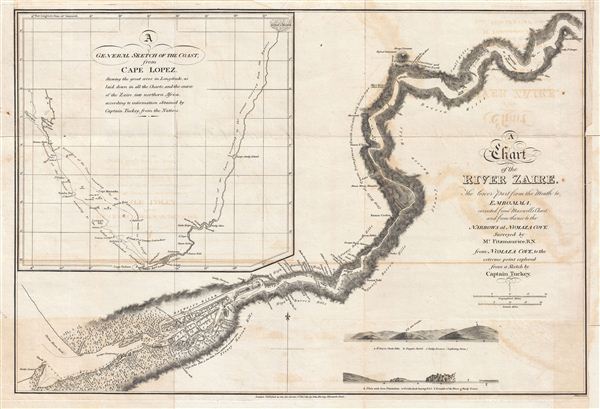

Title
A Chart of the River Zaire, the lower part from the Mouth to Embomma, corrected from Maxwell's Chart, and from thence to the Narrows at Numaza Cove.
1816 (dated) 13.5 x 20 in (34.29 x 50.8 cm)
1816 (dated) 13.5 x 20 in (34.29 x 50.8 cm)
Description
FOR THE ORIGINAL ANTIQUE MAP, WITH HISTORICAL ANALYSIS, CLICK HERE.
Digital Map Information
Geographicus maintains an archive of high-resolution rare map scans. We scan our maps at 300 DPI or higher, with newer images being 600 DPI, (either TIFF or JPEG, depending on when the scan was done) which is most cases in suitable for enlargement and printing.
Delivery
Once you purchase our digital scan service, you will receive a download link via email - usually within seconds. Digital orders are delivered as ZIP files, an industry standard file compression protocol that any computer should be able to unpack. Some of our files are very large, and can take some time to download. Most files are saved into your computer's 'Downloads' folder. All delivery is electronic. No physical product is shipped.
Credit and Scope of Use
You can use your digial image any way you want! Our digital images are unrestricted by copyright and can be used, modified, and published freely. The textual description that accompanies the original antique map is not included in the sale of digital images and remains protected by copyright. That said, we put significant care and effort into scanning and editing these maps, and we’d appreciate a credit when possible. Should you wish to credit us, please use the following credit line:
Courtesy of Geographicus Rare Antique Maps (https://www.geographicus.com).
How Large Can I Print?
In general, at 300 DPI, you should at least be able to double the size of the actual image, more so with our 600 DPI images. So, if the original was 10 x 12 inches, you can print at 20 x 24 inches, without quality loss. If your display requirements can accommodate some loss in image quality, you can make it even larger. That being said, no quality of scan will allow you to blow up at 10 x 12 inch map to wall size without significant quality loss. For more information, it is best consult a printer or reprographics specialist.
Refunds
If the high resolution image you ordered is unavailable, we will fully refund your purchase. Otherwise, digital images scans are a service, not a tangible product, and cannot be returned or refunded once the download link is used.
Cartographer
James Hingston (a.k.a. Kingston) Tuckey (August 1776 - October 4, 1816) was an Irish born British Naval officer and explorer active in the early 19th century. Tuckey was the son of a Protestant reverend, James Kingston, of Donoughmore, Ireland. Both of his parents suffered untimely deaths and he was subsequently raised by his grandmother. Turning 17, Tuckey, inspired by a family naval tradition, joined the Royal Navy. His naval career was marked by continuous front line action in various theaters, including the East Indies, India (where he developed Hepatitis), the Red Sea, and Australia. In Australia he was commissioned as the First-Lieutenant of the HMS Calcutta and published his adventures in the 1804 The Account of a Voyage to establish a Colony at Port Phillip in Bass's Strait. In the following year, the HMS Calcutta was captured by French forces and Tuckey, along with most of the other officers and passengers, were imprisoned in the French Citadel of Verdun, where met his wife Margaret Stuart, a fellow prisoner, and prepared Maritime Geography and Statistics, published shortly after his 1814 release. Tuckey's two published works reveal the mind of meticulous and scientific geographer. Tuckey was next commissioned to lead an exploratory mission up the Congo River (or River Zaire) with the mission determine if it communicated with the Niger River. Some of suggest that this commission was viewed as a reward or at least compensation for his long imprisonment, but in fact, given his poor health, it was nothing short of a death sentence. Nonetheless, Tuckey took to the command and the expedition was launched early in 1816. The team reached as far as Nsundi (on map as Soondy N’Sanga), where they were forced to turn back by lack of supplies and general expedition-wide ill health. Most of the expedition ultimately suffered from various tropical illnesses, including Tuckey himself, who died on October 4th at Moanda, on the coast of today's Democratic Republic of the Congo. Tuckey's journals were subsequently published verbatim by the Royal Geographical Society. Curiously, the Tuckey Expedition, though a near total disaster, inspired further British interest in African exploration. Tuckey is sometimes referred to as John Hingston Tuckey. We have been unable to definitively determine which name is correct. More by this mapmaker...
Source
Tuckey, J. K., Narrative of an Expedition to Explore the River Zaire, Usually Called the Congo, in South Africa, in 1816, (London: J. Murray) 1818.
References
New York Public Library, Map Division, Map Div. Sc Rare 916.75-T.