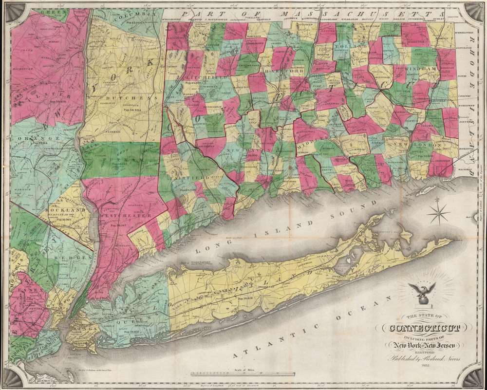
1852 Roderick Nevers Map of Connecticut and Long Island
Connecticut-nevers-1852$1,500.00

Title
The State of Connecticut Including Parts of New York and New Jersey.
1852 (dated) 22.75 x 28.25 in (57.785 x 71.755 cm) 1 : 316800
1852 (dated) 22.75 x 28.25 in (57.785 x 71.755 cm) 1 : 316800
Description
This is a strikingly vivid 1852 example of Roderick Nevers' map of Connecticut, Long Island, and eastern New York - published in Hartford. The map focuses on Connecticut, but emphasizes its connections to New York City via railroads in Connecticut, the Hudson Valley, and Long Island.
A Railroad Map
To produce this map, Roderick updated William Damerum's excellent map, retooling it to emphasize Connecticut's burgeoning railroad network. Among the railroads present are the New York and New Haven; the New Haven, Hartford, and Springfield; and the Norwich and Worcester. The Hartford, Providence and Fishkill Railroad also appears, along with its proposed route west of Hartford to Fishkill, where it was to meet the Hudson River Railroad. In New York, the Hudson River Railroad runs from Manhattan north to Redhook Landing. The Long Island Railroad stretches across Long Island from Brooklyn to Greenport.Even More Detail
Townships are highlighted with vivid wash color. The same level of detail does not translate to eastern New York, where the colors differentiate more generally between counties rather than townships. Towns and villages are labeled along the Hudson, along with other locations such as the U.S. Military Academy at West Point. Topography is loosely rendered with visual depictions of mountains.Publication History and Census
This 1852 map was published in Hartford by Roderick Nevers. Per Rumsey,First edition was 1851, a reissue of Damerum's 1815 map. The sixteen stars that surround the eagle in the cartouche stand for the sixteen states in the union when Damerum's plate was engraved by Peter Maverick in 1815, whose plate has been reengraved to produce the map. Stebbins in 1859 produced a map that follows this plate closely. Many changes have been made to the original plate to bring it up to date, particularly the delineation of railroads.While the original Maverick plate would have been in copper or steel, it is likely that this edition was transferred to lithographic stone - as was common in the 1850s. Scarce. We note three examples in OCLC: New York Public Library, the Connecticut Historical Society, and the Connecticut State Library. An example is also part of the David Rumsey Map Collection. Limited market history.
Cartographer
Roderick Nevers (April 30, 1808 - August 13, 1888) was an American printer and publisher. Born in Springfield, Massachusetts, Nevers worked in Hartford in the printing and publishing world from at least 1841 until 1887. He was a partner in the firm Case, Nevers, and Company, with Lucius Case and Alfred R. Skinner from at least 1841 until April 10, 1843. He was a partner in the firm Case and Nevers until 1849, when he opened his own firm, which he operated until 1887. Per his obituary, 'For nearly fifty years he was engaged in the business of engraving and plat printing, and a generation ago had no superior in that profession. He was a man of genial manners, and was universally esteemed. His death was in part the result of injuries received last winter by falling on an icy sidewalk.' He married Melissa Sykes Nevers (1812 - 1897) on October 6, 1835, with whom he had four children. More by this mapmaker...
Condition
Very good. Wear and light toning along original fold lines. Areas of reinforcement along left side where previously attached to binder. Accompanied by original binder.
References
Rumsey 2562.002. OCLC 20254230.