A large-format highly topographical and historical map of Corsica, produced by the Service géographique de l'Armée and published in 1933 as part of the series Forma Orbis Romani Cartes Archéologique de la Gaule Romaine.
A Closer Look
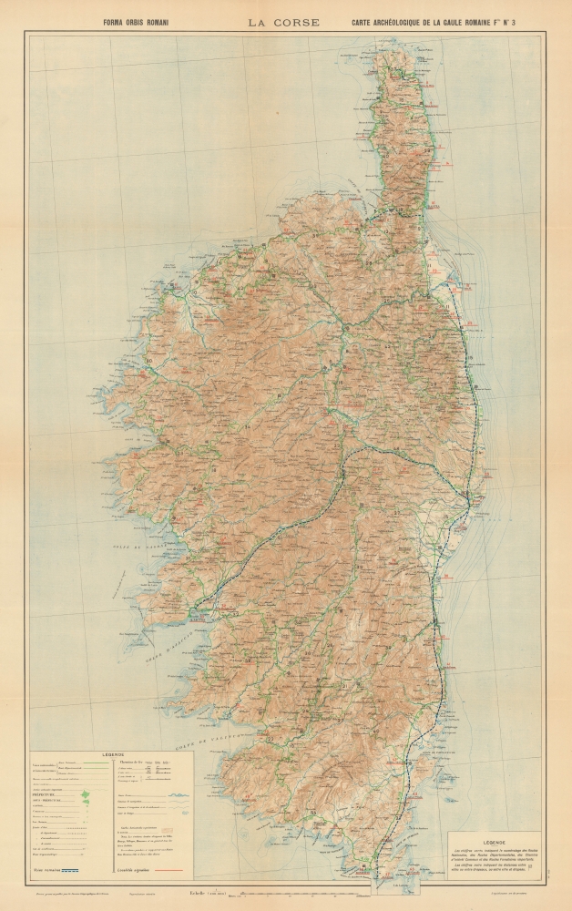
The island of Corsica, with its nearby waters and islands, is displayed in detail, with a focus on topography, including nautical soundings. Green figures label roads, with modern roads appearing in green also, while black numbers along roads indicate the distance between cities, towns, and flags (significant for military purposes). Roman Roads are marked prominently with blue dashed lines. Aside from roads, the map also records modern railways, administrative borders, settlements, and waterways.Corsica in Roman Times
Corsica was conquered by the Romans in 237 BCE (from the Etruscans and Carthaginians). Over time, the Romans built the main eastern coastal road and additional roads into the interior (including the one to Ajaccio seen here), which facilitated the island's gradual cultural and linguistic incorporation into the wider Roman Imperium. The island was conquered by the Vandals in 430 CE, bringing the Roman era to a close, though Justinian I (527 - 565) reconquered it for Byzantium, which governed it for two centuries.
The inclusion of this map in a series about Roman Gaul is curious as Corsica was never ruled by the Gauls. Being among several historically precarious territories along France's frontier, the authors of the series likely were keen to demonstrate that Corsica 'belonged' in France, against the wishes of local independence activists and pro-Italian fascists (the island was occupied by Italy with German assistance in 1942).Publication History and Census
This map was originally produced by the Service géographique de l'Armée, then modified slightly for inclusion in the third part of the twelve-part series Forma Orbis Romani : Cartes archéologique de la Gaule romaine, which was published over several years beginning in 1927. The entire project was overseen by Adrien Blanchet and the Académie des inscriptions et belles-lettres. Each map and accompanying text amounted to a mini atlas on their own, with a thorough examination of recorded history and archaeological sites. The present map is not independently cataloged with any institution, but the map and text of Part 3 of the series, dealing with Corsica, are cataloged together as being held by some forty to fifty institutions in Europe. An accurate census is difficult to establish, however, given the variations in cataloging (this third volume alone is listed some twenty times in the OCLC).
CartographerS
Service Geographique de L'Armee (fl. 1887 - 1940) was a French military mapping service. They published from 14c. Rue de Grenelle, Paris, France. More by this mapmaker...
Adrien Blanchet (March 8, 1866 - December 27, 1957) was a French scholar of ancient Rome and Gaul. He studied at the Ecole des Hautes Études and the Ecole du Louvre, taking courses with many of the leading French archaeologists of the time. He worked for many years at the Cabinet des médailles of the Bibliothèque nationale de France and was a leading expert on the coinage of the ancient world, serving as the Secretary and then Director of the Revue numismatique. He was elected a member of the Académie des Inscriptions et Belles-Lettres in 1919. His knowledge of the ancient world expanded into other fields as well, such as research on aqueducts. He oversaw the multipart atlas series Carte archéologique de la Gaule romaine in the late 1920s and early 1930s. Learn More...
Good. Light wear along original fold lines. Verso repairs at fold intersections. Very slight loss at some fold intersections.
OCLC 1272912892, 716567671, 77604038.