This item has been sold, but you can get on the Waitlist to be notified if another example becomes available, or purchase a digital scan.
1852 Levasseur Map of Corsica ( La Corse ), France
Corsica-levasseur-1852$100.00

Title
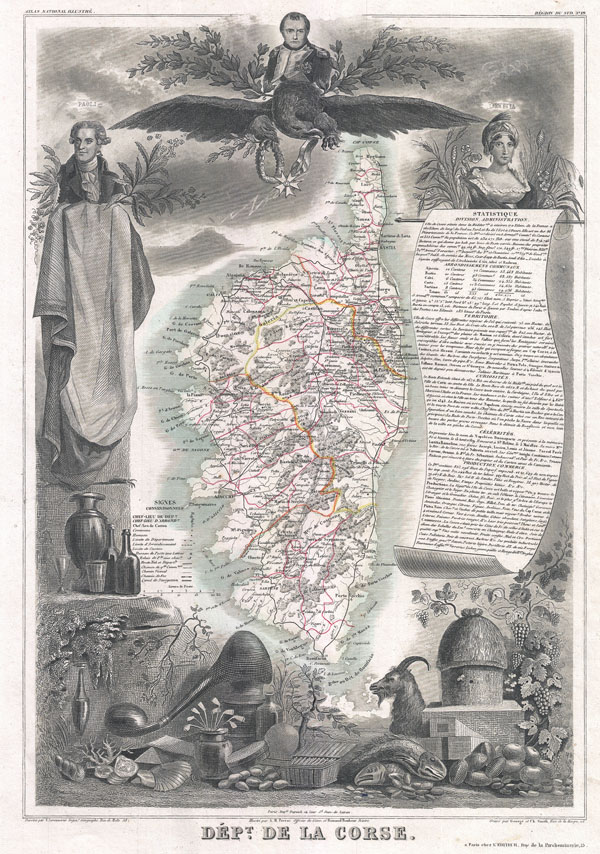
Dept. de la Corse.
1852 (undated) 16.5 x 12.5 in (41.91 x 31.75 cm)
1852 (undated) 16.5 x 12.5 in (41.91 x 31.75 cm)
Description
A visually stunning decorative map of Corsica (La Corse) dating to 1852, by French map publisher Victor Levasseur. Levasseur published several different editions of his Corsica map - this being first. The island of Corsica is drawn inconsiderable detail showing its many forests, roadways, cities, and three primary districts. By far this map's most striking feature is its elaborate allegorical border work. Levasseur composed this map for publication in his magnificent Atlas Nacionale de la France Illustree, one of the most decorative and beautifully produced atlases to appear in the 19th century. This particular map is surrounded on all sides with elaborate illustrative border work showing the cultural, natural, and trade richness of Corsica. Napoleon Bonaparte, Corsica's most celebrated son, appears at the top of the map, over a great imperial Eagle. To his right and left appear Paoli, a Corsican Nationalist Leader, and Loetitia, Napoleon's mother. The remainder of the decorative border work is given to displacing the the many products of Corsica, including Goats, honey, wines, distilled spirits, seafood, cheese, and sardines.
Publised by V. Levasseur in the 1852 edition of his Atlas National de la France Illustree.
Publised by V. Levasseur in the 1852 edition of his Atlas National de la France Illustree.
Cartographer
Victor Levasseur (1800 - 1870), an important French engineer, cartographer, and engraver of the mid 19th century, held a number of important cartographically related political and educations posts in France. He is most famous for his Atlas National Illustré des 86 Départements et des Possessions de La France, a large decorative atlas of France, including his Planisphere and five important continental maps. Levasseur's maps are distinctive for their wide decorative margins containing elaborate depictions of the scenery, peoples, and trade goods of the areas he mapped. Levasseur maps are also known to offer a wealth of statistical data. Until recently, very few Levasseur Atlases migrated out of France where they were mostly used in public libraries and town halls. His work represents some of the last great decorative atlases of the 19th century. More by this mapmaker...
Source
Levassuer, V., Atlas National Illustre des 86 Departements et des Possessions de La France Divise par Arrondissements, Cantons et Communea avec La Trace de Toutes Les Routes, Chemins,de fer et Canaux., 1852 edition.
Condition
Very good condition. Blank on verso.
References
Phillips (Atlases) 3003.