1564 Camocio and Forlani Map of Crete, Greece
Crete-camocio-1564$4,000.00
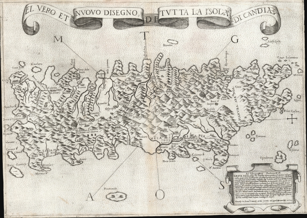

Title
El Vero et Nuovo Disegno di Tutto la Isola di Candia.
1564 (dated) 10.5 x 15 in (26.67 x 38.1 cm) 1 : 720900
1564 (dated) 10.5 x 15 in (26.67 x 38.1 cm) 1 : 720900
Description
This is a 1564 first-state Lafreri School map of Crete, engraved by Paolo Forlani and published by Giovanni Camocio. This north-oriented map illustrates the island's topography based on the late model exhibited first in the 1513 Waldseemüller map and introduced to Venice via Matteo Pagano's 1538 map. Waldseemüller's model was sufficiently authoritative to make it the prototype for all maps of the island until the 1563 map of the Cretan Calapoda became available.
The popularity of these works and their utility appear to have influenced Ortelius in his project of creating the first true, uniform atlas in 1570. Despite the proliferation of Italian mapmakers in the 1560s and 70s, only a few appear to have lived beyond the Italian plagues of 1575-77, and these survivors seem to have prospered mainly by their acquisition of plates engraved prior to those plagues. The absence of any Italian response to Ortelius' work is more likely to have been a product of the devastation wrought by the pestilence than any overwhelming superiority of the Flemish work.
A Closer Look
The map's engraving is clear and neat, with pictorial mountains, hachured coastlines, painstaking lettering, and restrained decorative elements. As with the map's precursors, it includes the Labyrinth of Daedalus: the legendary maze built for King Minos to contain the bull-headed Minotaur. While often considered to have been constructed at Knossos, recent archaeology suggests a series of tunnels at Gortyn, which is tantalizingly close to the location of the labyrinth symbol on these maps. This corresponds with Gortyna, the Cretan capital in the 1st century AD. Among other notable and tantalizing features are colonies of cave dwellings, yet another sign that the map was at least in part the result of actual visitation: such dwellings remain extant.Maps of the 'Lafreri' School
Between 1544 and the 1580s, Rome and Venice saw the production of a number of elegant, rare, and consequently now sought-after maps. These are frequently classified collectively as belonging to the 'Lafreri-School,' a term often used due to the survival of a 1572 catalog of maps from the stock of publisher Antonio Lafreri. The close resemblance of this list to the contents of various bound collections of Roman and Venetian maps of the period led to these proto-atlases to be attributed to Lafreri, despite the maps having been actually produced by over a dozen different mapmakers, including Gastaldi, Lafreri himself, his heir Duchetti, the Bertellis, Camochio, Zenoni, Salamanca, Forlani, Ligorio, Tramezini, Zaltieri and others. These cartographers, mapmakers, engravers, and publishers, some of whom shared formalized partnerships, left behind a legacy of some six or seven hundred maps, all of which are marked by scarcity due to their not having been included in a standard atlas. Though these were generally sold in assembled-to-order, composite 'atlases,' the contents of these works varied wildly, and those that survive are often poorly cataloged. Since the maps in these composite works were not intended to be compatible with one another, bookbinders had to go to sometimes extreme lengths to combine them: pasting smaller maps down onto larger sheets, which were then stitched into the books, larger maps trimmed close and then folded to fit smaller bindings. We have also encountered some maps, usually found separately, yet printed to the same sheets to be included together in bound works.The popularity of these works and their utility appear to have influenced Ortelius in his project of creating the first true, uniform atlas in 1570. Despite the proliferation of Italian mapmakers in the 1560s and 70s, only a few appear to have lived beyond the Italian plagues of 1575-77, and these survivors seem to have prospered mainly by their acquisition of plates engraved prior to those plagues. The absence of any Italian response to Ortelius' work is more likely to have been a product of the devastation wrought by the pestilence than any overwhelming superiority of the Flemish work.
Publication History and Census
According to Woodward, this map was engraved by Paolo Forlani in 1564 on behalf of Giovanni Camocio, who owned the plate. A second state of the map, bearing Bertelli's imprint, is unlikely to be earlier than 1573 (Bertelli inherited the plates after Camocio's death). At least one further state, with changes to the coastline, is recorded. Only five examples are cataloged in OCLC.CartographerS
Giovanni Francesco Camocio (Camozzi)(???? - c. 1575) was a Venetian cartographer, map publisher and printer. He was one of the most prolific of the so-called Lafreri school of Italian mapmakers in the second part of the sixteenth century. Little is known of Camocio's early years. His birthdate and place are not known. He is thought to have lived in Asola (near the Venetian fortress of Crema). In 1552 'Giovanni Francesco Camozzi' and his partners petitioned the Doge of Venice for a 15 year privilege for two books in progress, one a translation of a Greek medical text and the other a translation of Aristotle's Meteorology. The latter was published in 1556 by which time he was operating free of his unnamed partners. He would publish eleven more books until 1571, by which point he is known to have his own copper-plate printing shop. His output includes engravings of drawings and paintings by Titian, and various religious scenes. He is best known as a map printer, being among the Italian map publishers known collectively as the 'Lafreri' school (after Antonio Lafreri, the first of these to include a title sheet in his composite atlases.) The period between 1560 and 1575 resulted in Camocio's publication of no fewer than 36 large maps and many smaller format works. The end point of Camocio's production coincided with the plague which devastated Venice between 1574 and 1577. As there is no record relating to the man after 1575, it is very likely that he succumbed to the pestilence. More by this mapmaker...
Paolo Forlani (fl. 1560-1571) was an Italian cartographer and engraver of maps and views, working in Venice between 1560 and 1571. His early life is obscure: he is thought to have hailed from Verona. There is not even a date available for his death, although it is probable that he was claimed by the 1574-75 plague that killed 30% of Venice's population, and which seems to have impacted the printing community of that city disproportionately. Even within the narrow period of 1560 to 1571, there are about a hundred maps and prints that can be attributed to him, so it is probable that he was even more prolific. A good census of his work is complicated by the fact that most of his work was printed by other publishers under their imprints: Forlani engraved maps and views for Camocio, Bertelli and Zaltieri. Matters are complicated by the reprinting of plates by two or more publishers, as plates were handed down from one to another. Learn More...
Condition
Excellent. Trimmed close but borders complete. Else fine with a bold, sharp strike.
References
OCLC 1062274211. Zacharakis, C. G., A Catalogue of Printed Maps of Greece 1477-1800 808.