1856 Bernardo y Estrada Map of Cuba
Cuba-bernardoestrada-1856$850.00
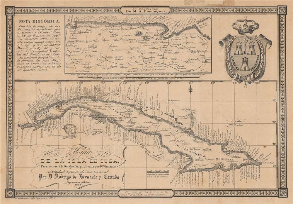

Title
Mapa de la Isla de Cuba, para servir a la Geografía publicada por D.P. González...
1856 (dated) 9 x 13 in (22.86 x 33.02 cm) 1 : 4000000
1856 (dated) 9 x 13 in (22.86 x 33.02 cm) 1 : 4000000
Description
A rare 1856 map and chart of Cuba by Rodrigo de Bernardo y Estrada, displaying the coastlines of the main island and surrounding islands. It was produced during Cuba's mid-19th-century sugar boom.
The top portion of the sheet is composed of supplemental material, including a historical note providing basic information about the island, the coat of arms of the city of Havana, and an inset map of the area to the east and south of Havana, highlighting the railway network connecting the capital with nearby cities. This network had been growing continuously in the years before publication, starting with the opening of a line from Havana to Bejucal in 1837, the first steam railway in Latin America, predating any in Spain itself.
At the same time, the slave trade came under greater international scrutiny and even military pressure by the British, leading it to be outlawed in Cuba in 1865. Still, Cuba's sugar boom was made possible by the 1834 abolition of slavery in British Caribbean colonies, especially sugar-producing colonies like Jamaica and Barbados. Despite a series of revolts by slaves, freedmen, and abolitionists throughout the early 19th century, slavery itself continued to be practiced in Cuba until 1886, but was increasingly replaced with the use of contract laborers and indentured servants from China and elsewhere.
A Closer Look
This map features a detailed coastline, noting capes, points, coastal rivers, hazards, sand banks, and more - suggesting its sources were nautical charts. In the interior, major cities and towns are noted, but the focus is on transportation networks.The top portion of the sheet is composed of supplemental material, including a historical note providing basic information about the island, the coat of arms of the city of Havana, and an inset map of the area to the east and south of Havana, highlighting the railway network connecting the capital with nearby cities. This network had been growing continuously in the years before publication, starting with the opening of a line from Havana to Bejucal in 1837, the first steam railway in Latin America, predating any in Spain itself.
Cuba's Sugar Boom
The primary impetus for the railways was the collection and transportation of sugar. The construction of the railways, along with slave labor and the adoption of steam-powered machinery, facilitated the Cuban sugar boom of the mid-19th century, through which by 1860, Cuba produced one-third of the world's sugar.At the same time, the slave trade came under greater international scrutiny and even military pressure by the British, leading it to be outlawed in Cuba in 1865. Still, Cuba's sugar boom was made possible by the 1834 abolition of slavery in British Caribbean colonies, especially sugar-producing colonies like Jamaica and Barbados. Despite a series of revolts by slaves, freedmen, and abolitionists throughout the early 19th century, slavery itself continued to be practiced in Cuba until 1886, but was increasingly replaced with the use of contract laborers and indentured servants from China and elsewhere.
Publication History and Census
This map was produced by Rodrigo de Bernardo y Estrada and lithographed by Marquier in Havana in 1856 to accompany a geographical text, probably Pelayo González's Elementos de geografía e historia de la Isla de Cuba. Its only institutional holding is with the Biblioteca Nacional 'José Martí' in Havana, and it has no known history on the market. An 1868 edition is held by Stanford University.Cartographer
Rodrigo Bernardo de Estrada (fl. c. 1840 - 1860) was a Cuban lawyer and surveyor active in the middle part of the 19th century. It appears to have had some sort of official designation, but we have been able verify any governmental position. Bernardo de Estrada's work is most frequently associated with Sagua la Grande, Cuba. More by this mapmaker...
Condition
Good. Patch and old tape residue upper margin. Small wormholes in the text of 'Rio S. Diego' towards left and to the left of Isla Verde at right. Light foxing.
References
OCLC 1006788319 (1868 edition).