This item has been sold, but you can get on the Waitlist to be notified if another example becomes available, or purchase a digital scan.
1816 Dirección de Hidrografía Chart, Coasts of Cumana, Venezuela, Trinidad, Tobago
Cumana-direccionhidrografia-1816$475.00


Title
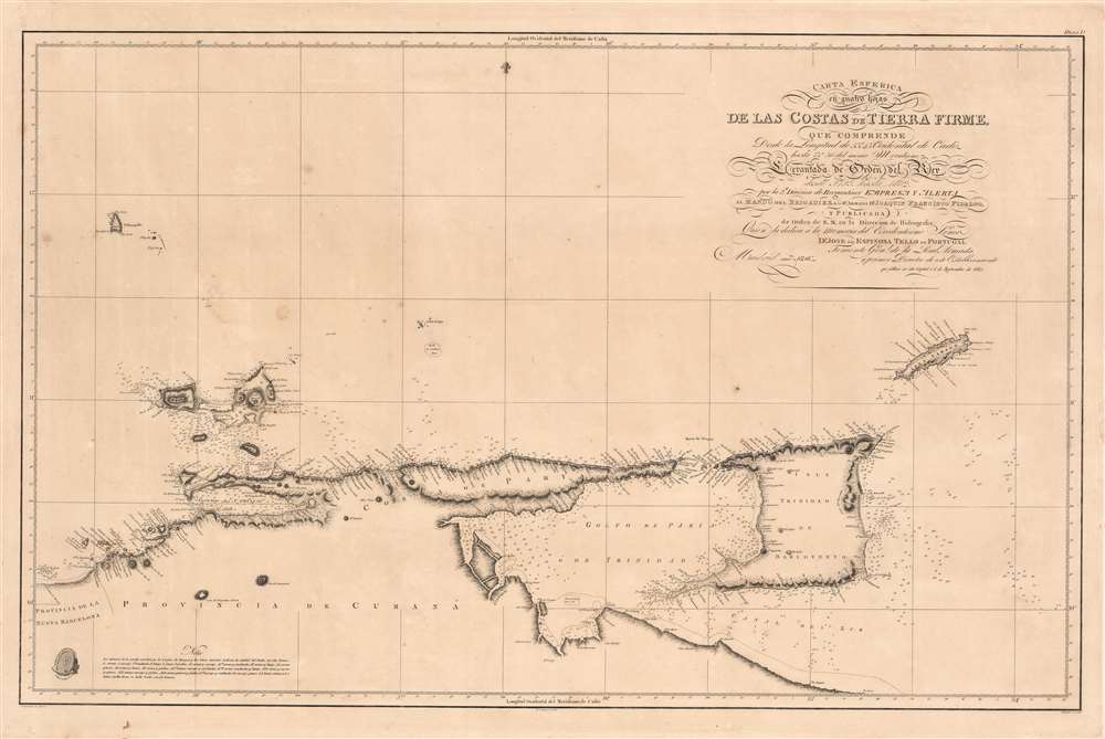
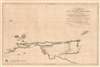
Carta Esferica en quatro hojas de las Costas de Tierra Firme.
1816 (dated) 23.75 x 37.5 in (60.325 x 95.25 cm) 1 : 610000
1816 (dated) 23.75 x 37.5 in (60.325 x 95.25 cm) 1 : 610000
Description
This is a rare 1816 Dirección de Hidrografía chart of what is now northern Venezuela and the island nation of Trinidad and Tobago. It is the product of an effort by the Spanish to better understand the coasts of their waning empire at the end of the 18th century, resulting in charts markedly improved over their predecessors.
The surveys that contributed to this chart were undertaken during the French Revolutionary Wars of the 1790s and its publication was likely delayed due to the subsequent Napoleonic Wars (1803 - 1815), including the occupation of Spain and the removal of the Bourbon monarchy. Although Spain was not the global superpower it had been two centuries earlier, it was still a major player on the world stage and, throughout the 18th century, sparred with rival powers, especially the British. In such a struggle, accurate nautical charts of potential sites for naval warfare were a significant advantage.
The collapse of the Spanish Empire in the early 19th-century obscures the reforms and accomplishments of the late 18th century, including a range of scientific voyages of exploration. The New World was especially fertile ground for these developments, and a distinct late 18th-century Spanish American Enlightenment mentality may have contributed to the populist Latin American Independence Movements of the 19th century.
A Closer Look
Coverage includes the coastline of the Provincia de Cumaná, an administrative unit of the Capitanía General de Venezuela, and surrounding islands, including Trinadad, Tobago, and Margarita. Soundings are provided in fathoms, set as 6 Burgos feet (despite standardization efforts around this time, there was still widespread local variation in Spanish units of measurement, requiring such clarification). Sandbanks, islets, placers, and other hazards are indicated in great detail, including a system of letters corresponding to a variety of types and mixtures of sand, mud, gravel, and silt. Mountains and hills on land are also recorded. It is worth noting the use of the Cadiz Meridian, which became a popular measurement in the 18th century, particularly for use in travel to and about the New World.A Waning Empire
These waters were charted by Cosme Damian Churruca and Joaquin Fidalgo (not to be confused with his contemporary, Salvador Fidalgo, who explored the Pacific Coast from Vancouver to Alaska for Spain). Throughout the early 1790s, Fidalgo and Churruca traveled the Caribbean, trading, exploring, and preparing much-improved charts of the coastlines. By the time this chart was printed, Fidalgo had risen to be the director of the Dirección de Hidrografía, while Churruca had been killed at the 1805 Battle of Trafalgar.The surveys that contributed to this chart were undertaken during the French Revolutionary Wars of the 1790s and its publication was likely delayed due to the subsequent Napoleonic Wars (1803 - 1815), including the occupation of Spain and the removal of the Bourbon monarchy. Although Spain was not the global superpower it had been two centuries earlier, it was still a major player on the world stage and, throughout the 18th century, sparred with rival powers, especially the British. In such a struggle, accurate nautical charts of potential sites for naval warfare were a significant advantage.
The collapse of the Spanish Empire in the early 19th-century obscures the reforms and accomplishments of the late 18th century, including a range of scientific voyages of exploration. The New World was especially fertile ground for these developments, and a distinct late 18th-century Spanish American Enlightenment mentality may have contributed to the populist Latin American Independence Movements of the 19th century.
Publication History and Census
This chart was produced in 1816 by the Dirección de Hidrografía in Madrid based on original drafts by C. Noguera and M. Moreno, members of Joaquin Fidalgo's crew. It was then drawn by J. Morata and engraved by F. Cardano. There are at least two states of this chart, one with the 'Nota' under the title and the present state with the 'Nota' moved to bottom-left. Only four institutions are cataloged in the OCLC as holding this chart and it is scarce to the market.Cartographer
The Direccion Hidrografía (1787 - 1927), also known as the Deposito Hydrografico and the Direction de Hidrografía, was the Spanish equivalent of the British Admiralty or the U.S. Coast Survey. This organization, founded in 1787, was commissioned to collect and produce accurate nautical charts of all waters frequented by Spanish vessels. In essence, it replaced the Casa de la Contratación de las Indias (House of Trade of the Indies), which closed its doors in 1790. Like most such organizations, the Direccion Hidrografía marked a new age in cartography. Rather than simply collect charts created by navigators, explorers, and merchants, the Direccion Hidrografía worked closely with naval and military personnel to mount cartographic and hydrographic expeditions in pursuit of the most accurate hydrographical, astronomical, and geodetic measurements. The Direccion Hidrografía created a massive library of nautical charts that, though not nearly as common as similar nautical charts by the U.S. Coast Survey and British Admiralty, are highly desirable for the beauty of their manufacture as well as their accuracy and detail. The office was originally located on Calle Ballesta, but relocated to 36 Alcala, both in Madrid. After 1908 the Dirección was subsumed into other governmental agencies. In 1927 the Direccion was absorbed into the Institute and Observatory of San Fernando, located in Cadiz. The library of original maps, charts, and journals was transferred to the Naval Museum of Madrid - where it resides to this day. More by this mapmaker...
Condition
Very good. Even toning. Occasional spots of discoloration.
References
OCLC 431791618, 803469472, 1082901909, 165564421.