This item has been sold, but you can get on the Waitlist to be notified if another example becomes available, or purchase a digital scan.
1944 Chapin Map of Eastern Europe and the Soviet Union's Imperial Desires
CzarsWill-chapin-1944$275.00

Title
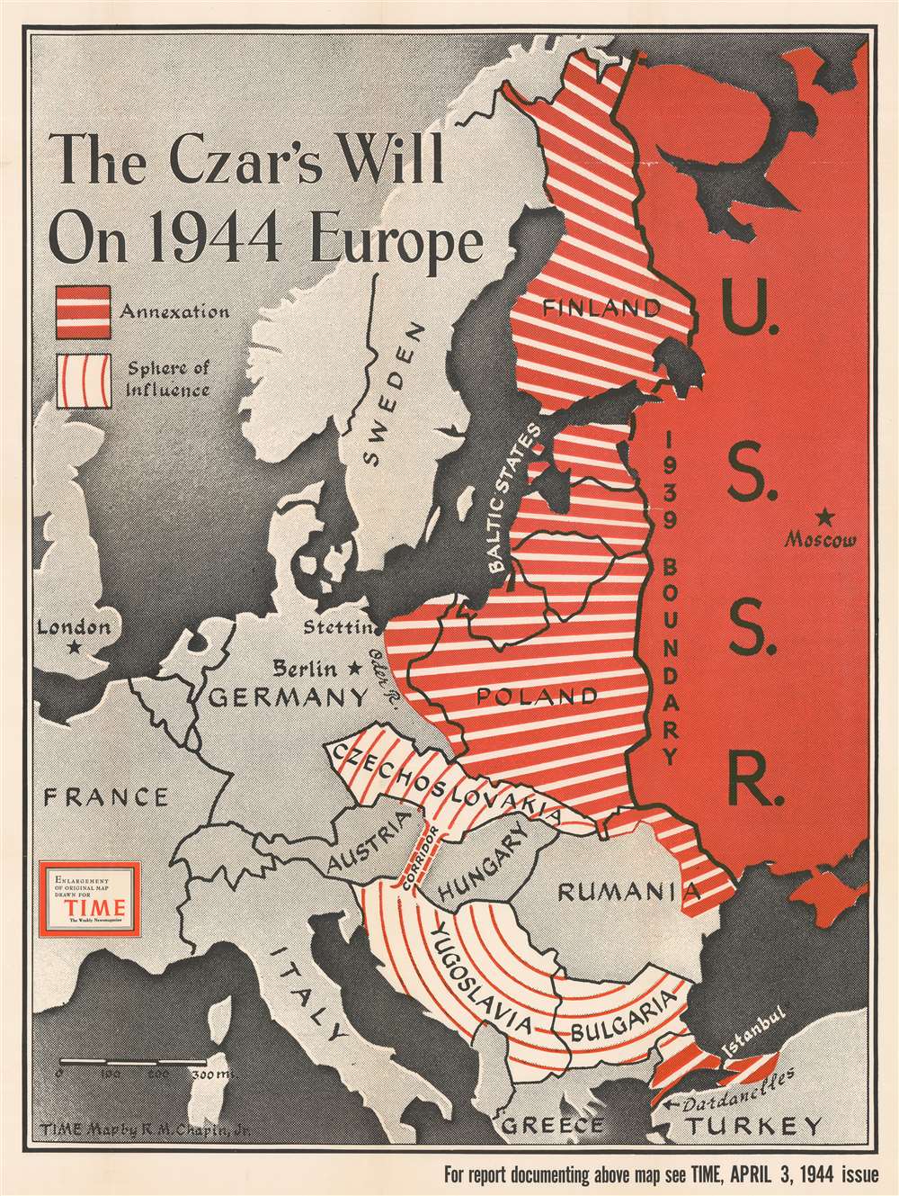
The Czar's Will on 1944 Europe.
1944 (dated) 44 x 32.75 in (111.76 x 83.185 cm) 1 : 3540000
1944 (dated) 44 x 32.75 in (111.76 x 83.185 cm) 1 : 3540000
Description
Dating from an era when the United States was fighting a truly global war against Nazi Germany and Imperial Japan, this 1944 Robert M. Chapin Jr map of Eastern Europe takes aim at neither of America's two official enemy states, but one of its allies. The map depicts the region from England and Scotland to the U.S.S.R and from the Arctic Ocean to Turkey and warns of the 'czar's will' to annex and exert influence over vast swaths of Eastern Europe. The Soviet Union is shaded red, a color traditionally associated with Communism, and is illustrated within its 1939 borders, while western Europe is shaded gray. The space in between, the areas the Soviets are supposedly eyeing, are shaded with two different patterns of red and white stripes. Parts of Europe that are apparently going to be annexed, shaded with thick red stripes and thin white stripes, include Finland, all three of the Baltic states (Estonia, Latvia, and Lithuania), Poland, eastern Germany, and eastern Romania. The Bosporus and the Dardanelles are also going to be annexed (which means Istanbul would fall into Soviet hands), finally satiating Russian desires for a secure warm-water port along the Black Sea. This would effectively make the Soviet Union an imperial power in Eastern Europe, replacing the hegemony of the Nazis. It must not be forgotten, however, that direct control is not the only method referenced here. Czechoslovakia,
Relations Between the Western Allies and the Soviet Union
This piece, which is obviously not an official map of the United States government, wonderfully illustrates how relations between the Western Allies (Britain and the United States) and the Soviet Union began to fray as World War II continued on into yet another year. These three governments were 'strange bedfellows', and it was said by more than one official that they did not mind watching the Nazis and the Soviets fighting each other in the frozen expanses of Eastern Europe. However, it became more and more apparent that Stalin had designs on expanding his sphere of influence after the war, as this map brutally illustrates.Publication History and Census
This map was created by Robert M. Chapin for TIME Magazine and was originally published to accompany an article in the April 3, 1944 issue. TIME subsequently published this edition of the map separately. The OCLC records examples of this map as being part of the collection at Franklin and Marshall College and the University of Illinois Urbana-Champaign.Cartographer
Robert M. Chapin Jr. (fl. 1933 - 1970) was a prominent architect, cartographer and illustrator active during World War II and the Cold War. Chapin graduated from the University of Pennsylvania in 1933 with a degree in architecture. Since this was the height of the Great Depression, and architects in low demand, he instead took work as a staff cartographer at Newsweek. Catching the attention of Manfred Gottfried of Time, Chapin was offered an accepted a position at the head of Time's cartography department. He remained with Time for some 33 years, from 1937 to 1970, often drawn 2 - 3 new thematic maps weekly. With an architect's gift visualizing information, Chapin became a skilled informational cartographer, heading the cartography department at Time Magazine. Chapin, like Fortune Magazine chief cartographer, Richard Edes Harrison, Chapin was at the forefront of infographic propaganda cartography, a genre that matured during the World War II Era and remains popular today. Working for Time Magazine, Chapin developed a signature style for his long run of 'War Maps.' Chapin was known for his maverick airbrush technique which lead to strong color splashes and intense shading. He also incorporated celluloid stencils to illustrate bomb explosions, flags, sinking ships, and more - generating a instantly recognizable standardized style. Chapin's Time war maps were further distinctive for their use of strong bold reds as a universal symbol of hostility. Chapin graduated from the University of Pennsylvania in 1933 with a degree in architecture. Since this was the height of the Great Depression, an d architects in low demand, he instead took work as a staff cartographer at Newsweek. Catching the attention of Manfred Gottfried of Time, Chapin was offered an accepted a position at the head of Time's cartography department. He remained with Time for some 33 years, from 1937 to 1970, often drawn 2 - 3 new thematic maps weekly. Chapin live in Sharon Connecticut. More by this mapmaker...
Condition
Very good. Even overall toning. Wear along original fold lines. Verso repairs to fold separations and at fold intersections. Areas of infill at fold intersections. Has old institutional collection stamp on verso. We have contacted the institution to verify that this item was legally deaccessioned.
References
OCLC 320454127.