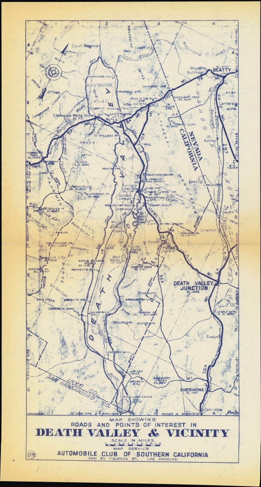
Title
Map Showing Roads and Points of Interest in Death Valley and Vicinity.
1935 (undated)
15.75 x 7.5 in (40.005 x 19.05 cm)
1 : 400000
Description
A scarce separately issued map of Death Valley and surroundings near the border of California and Nevada, produced c. 1930 by the Automobile Club of Southern California. It captures the region at a moment of transition from an isolated base for scattered mining operations to a tourist attraction known for its hot springs and stunning natural beauty.
A Closer Look
Oriented towards the northwest, the map covers the area between Beatty, Nevada ('the Gateway to Death Valley') and Shoshone, California near the border of Inyo and San Bernardino County. Death Valley and the Amargosa River are marked out in a strip down the center of the map, with elevations below sea level noted at various points. On either side of the valley are mountains, canyons, springs, wells, mills, and mining operations, especially directed at extracting borax. Many features have colorful names, such as the 'Devil's Golf Course,' which is not a golf course at all, but a desolate field of jagged little hills made of salt that have been eroded over centuries to look like a landscape from an alien world.
Several towns are indicated around the valley; these rose and fell with mining operations, and most are now ghost towns or nearly so. Two locations are named after Christian Brevoort Zabriskie, long-time general manager of the Pacific Coast Borax Company, the largest operation in Death Valley in the late 19th and early 20th century. At the same time, the appearance of the Stovepipe Wells Hotel and Furnace Creek Inn point to the future of Death Valley as a tourist attraction and refuge for convalescents.The First Proper Road through Death Valley
The unsigned road running north-south along the valley is noted at left as 'toll road'; this was the Eichbaum Toll Road, named after its creator Herman Eichbaum. After several attempts to build a toll road in the early 1920s, Eichbaum was finally able to construct and open this road in 1926 (today it is CA SR 190). Other paved (thick bold lines) and unpaved (thin lines) roads are also marked.Tonopah and Tidewater Railroad
Also notable is the Tonopah and Tidewater Railroad, which was meant to connect Tonopah, Nevada (north of Beatty) with San Diego, but which never reached either intended terminus on its own rails. Like limited earlier attempts to build a railroad through Death Valley, the Tonopah and Tidewater was primarily designed to move borax. The main line intersected with a narrow-gauge branch line to Ryan, California (formerly the Death Valley Railroad) at Death Valley Junction (also known as Amargosa). Ryan was a classic company town built around a borax mine that became a ghost town when mining operations shut down (the remnants of the town are now owned by the Death Valley Conservancy).From Hellhole to Tourist Haven
Death Valley was named by early gold rush-era emigrants from the eastern United States who were stuck in the valley for several harrowing weeks and barely managed to survive. In the late 19th century, operations were established to extract salts, borate, and talc, and later gold, silver, copper, and lead. However, the climate was so harsh and infrastructure so underdeveloped that 'twenty mule teams' (actually two horses and eighteen mules) were required to brave travel through the valley, or, in later periods, to get borax to the rudimentary mining railroads built there. The borax mines and other operations declined over the course of the early 20th century, but soon afterwards, tourists began flocking to Death Valley's springs. Eccentric millionaires built elaborate Spanish Revival homes in the region, movie stars began to extol its virtues, and the Stovepipe Wells Hotel and Furnace Creek Inn noted here became famous throughout the Southwest. This tourism boom was made possible by the increasing use of automobiles and the improvement of roads, such as they were, to and through Death Valley, neatly aligning with the interests of the Automobile Club of Southern California.Publication History and Census
This map was published by the Automobile Club of Southern California around the year 1930. Though a previous owner penciled in the date 1939 in the bottom margin, it looks to predate the designation of the valley as a National Monument and construction undertaken by the Civilian Conservation Corps in the mid-1930s. At the same time, it includes the Stovepipe Wells Hotel and Furnace Creek Inn, so it must date from 1927 or later. The initials F.M.B. at bottom-right belong to Forrest M. Burke, who drew many of the A.C.S.C. maps of the era. This map is numbered 1378 in the A.C.S.C. series; it was incorporated into a larger map of the California-Nevada border region (number 1379, also sold by us as MojaveColoradoDeserts-autoclub-1933), but we are unaware of any other separately-issued examples in institutional collections or on the market.
Cartographer
The Automobile Club of Southern California (1900 - Present) is an auto club based in Los Angeles, California and an affiliate of the American Automobile Association (AAA). Founded in 1900, it was one of the first auto clubs in the United States and was dedicated to proposing traffic laws, improving road conditions, and the overall improvement of driving conditions. The Auto Club began producing its own maps in 1910, when it sent out its own team of cartographers to survey the state's roads. Its main office at the corner of Figueroa Street and Adams Boulevard was completed in 1923. Numbering nearly 8 million members in its home territory alone, today it is the largest single member of the AAA federation More by this mapmaker...
Condition
Very good. Light toning along original centerfold.