This item has been sold, but you can get on the Waitlist to be notified if another example becomes available, or purchase a digital scan.
1866 Mathews View Map of Denver, Colorado
Denver-mathews-1866$1,100.00

Title
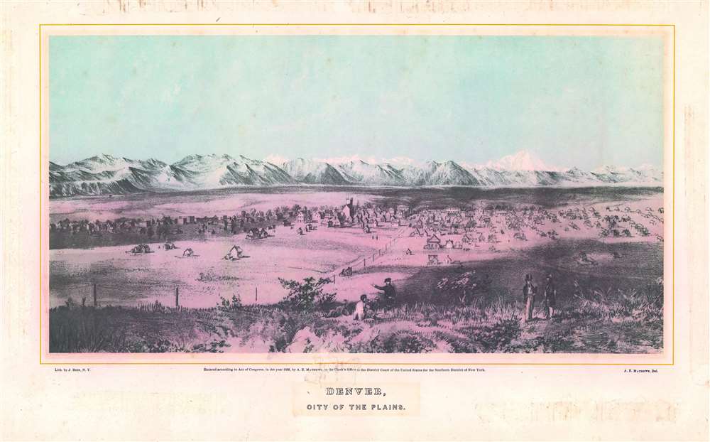
Denver, City of the Plains.
1866 (dated) 10.5 x 16.5 in (26.67 x 41.91 cm)
1866 (dated) 10.5 x 16.5 in (26.67 x 41.91 cm)
Description
This is an important Alfred Edward Mathews 1866 bird's-eye view of Denver, Colorado. The view includes the then separate towns of Auraria and Denver as seen from a hill about one mile east of the South Platte River looking west towards modern-day downtown. Although the South Platte itself is not obvious, we can recognize it from the narrow band of development on both sides of the river. The tall building at center is probably the Methodist Church constructed in 1864 at 14th Street and Lawrence. A road extends from the foreground into the center of the city and is consistent with modern day 15th or 16th Street. Shooting an arrow along this road into the background leads, some 60 miles distant, directly to Longs Peak. Pikes Peak may be on the far left, but we are not 100% confident in our identification. The bluff in the foreground from which the view was drawn, is most likely somewhere in the vicinity of the modern-day capital.
Publication History and Census
This view was issued to accompany Mathew's famous book, Pencil Sketches of Colorado and featured some of the most important and realistic early illustrations of Colorado life. The present view is based on Mathew's own pencil sketch and was engraved and printed in 1866 by New York lithographer Julius Bien. A great rarity. An example of the separate view is part of the collection at the New York Public Library. Pencil Sketches of Colorado is well represented in institutional collections.CartographerS
Alfred Edward Mathews (June 24, 1831 – October 30, 1874) was an English born American artist, author, and illustrator active in the middle part of the 19th century. Mathews was born in Bristol, England in 1831. His family emigrated to the United States and 1833 where they settled in Rochester, Ohio. There Mathews took work as a typesetter in his brother, Charles Mathews; newspaper, the Ohio Democrat. In the 1850s Alfred too new work as a traveling bookseller where he traveled throughout New England. Later in the 1850s he found work as a school teacher in Tuscaloosa County, Alabama. With the outbreak of the Civil War, Mathews returned to Ohio and enlisted in the Union Army, where he served with the 31st Ohio Volunteer Inventory. He participated in the Siege of Corinth and the Battles of Stones River, Lookout Mountain, and Mission Ridge. He proved an able draughtsman and produced topographical maps and views of important war events, including a panorama of Vicksburg. After the war Mathews headed west, settling briefly in Nebraska City before moving on to Denver, where his November 13, 1865 arrival was noted Rocky Mountain News. He began work immediately on a book of views and sketches highlighting the beauty and commercial prosperity of Colorado. The work proved both poplar and influential, earning him additional work in other Colorado cities, Montana, and California. Eventually he settled into a home on the Big Thompson River, west of Boulder. After only a few months there he contracted appendicitis and died on October 30, 1874. More by this mapmaker...
Julius (Julien) Bien (September 27, 1826 - December 21, 1909) was a German-Jewish lithographer and engraver based in New York City. Bien was born in Naumburg, Germany. He was educated at the Academy of Fine Arts, Cassell and at Städel's Institute, Frankfurt-am-Main. Following the suppression of the anti-autocratic German Revolutions of 1848, Bien, who participated in the pan-German movement, found himself out of favor in his home country and joined the mass German immigration to the United States. Bien can be found in New York as early as 1849. He established the New York Lithographing, Engraving & Printing Company in New York that focused on the emergent chromo-lithograph process - a method of printing color using lithographic plates. His work drew the attention of the U.S. Government Printing Office which contracted him to produce countless government maps and surveys, including the Pacific Railroad Surveys, the census, numerous coast surveys, and various maps relating to the American Civil War. Bien also issued several atlases both privately and in conjunction with a relation, Joseph Bien. At the height of his career Bien was elected president of the American Lithographers Association. After his death in 1909, Bien's firm was taken over by his son who promptly ran it into insolvency. The firm was sold to Sheldon Franklin, who, as part of the deal, retained the right to publish under the Julius Bien imprint. In addition to his work as a printer, Bien was active in the New York German Jewish community. He was director of the New York Hebrew Technical Institute, the New York Hebrew Orphan Asylum, and president of the B'nai B'rith Order. Learn More...
Source
Mathews, A. E., Pencil Sketches of Colorado, its Cities, Principal Towns and Mountain Scenery, (New York) 1866.
Condition
Good. Adhesive around outer margins professionally removed. There was also some adhesive between the title and the copyright notice, which has left minor damage. Some matte burn. Backed on archival tissue. In most institutional examples of this view still in the book, the foreground is yellow/brown and the background has a bluish tint. The present example has a pinkish cast in the foreground which may be a result of a printing quark or exposure to acid, sunlight, and extended early framing. Otherwise, a very nice example of a very rare view.
References
Reps, John, Views and Viewmakers of Urban America, (University of Missouri, Columbia, 1984), #482. OCLC 318571622. Stokes P.1865-G-71. The Miriam and Ira D. Wallach Division of Art, Prints and Photographs: Print Collection, The New York Public Library.,(1866) Denver, city of the plains.