This item has been sold, but you can get on the Waitlist to be notified if another example becomes available, or purchase a digital scan.
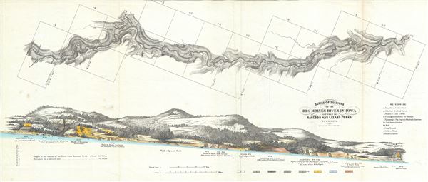
1852 Owen Geological Map of the Des Moines River, Iowa
DesMoinesRaccoonLizard-owen-1852$150.00

Title
Series of Sections on the Des Moines River in Iowa, between the Raccoon and Lizard Forks.
1852 (undated) 12 x 28 in (30.48 x 71.12 cm) 1 : 18800
1852 (undated) 12 x 28 in (30.48 x 71.12 cm) 1 : 18800
Description
This is a beautiful 1852 geological map of the Des Moines river in Iowa by D. D. Owen. It covers the flow of the Des Moines River, a tributary of the Mississippi, between the Raccoon and Lizard Forks (roughly from Des Moines city to Fort Dodge) and notes the rock and soil composition throughout. A beautifully rendered cross section is included in the lower half of the map with geologic cross-sections depicted in color. A table of references is included in the lower right quadrant. This map was published by Lippincott, Grambo and Company to accompany the 1852 Report of a Geological Survey of Wisconsin, Iowa and Minnesota; and incidentally of a Portion of Nebraska Territory.
Source
Lippincott, Grambo and Co., Report of a Geological Survey of Wisconsin, Iowa and Minnesota; and incidentally of a Portion of Nebraska Territory, (Philadelphia) 1852.
Condition
Very good. Minor wear and toning along original fold lines. Minor spotting.
References
Rumsey 690.044.