This item has been sold, but you can get on the Waitlist to be notified if another example becomes available, or purchase a digital scan.
1855 Topographical Engineers Map of the Dubuque Harbor
DubuqueHarbor-topoengin-1855$62.50

Title
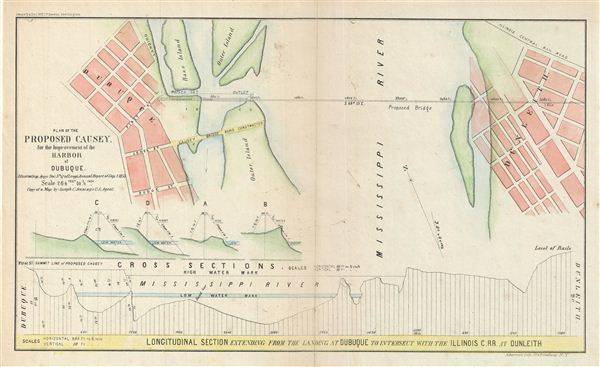
Plan of the Proposed Causey. For the Improvement of the Harbor of Dubuque.
1855 (dated) 9 x 14.5 in (22.86 x 36.83 cm)
1855 (dated) 9 x 14.5 in (22.86 x 36.83 cm)
Description
This is an uncommon example of the 1855 Corps of Topographical engineers map illustrating the proposed causey (route) at Dubuque Harbor, Iowa. The map covers from Dubuque to Dunleith across the Mississippi River and features a longitudinal section extending from the landing at Dubuque to intersect with the Illinois Central Rail Road in Dunleith. The Julien Dubuque Bridge, built in 1943 lies just south of the proposed bridge. engraved by Ackerman, this map is part of Long's Annual Report of Sep. 1, 1855.
Cartographer
Army Corps of Topographical Engineers (fl.1838 - 1863) refers to the an elite branch of the U.S. Army created on July 4, 1838 to perform civil mapping and survey work throughout the United States. The origins of the Corps of Topographical Engineers can be traced back to the American Revolutionary War, where General George Washington recognized the need for accurate surveys pursuant to military action. Shortly following the war, in 1779, a civilian engineering corps was created by act of Congress. Identified in 1802 by Thomas Jefferson, the "Corps of Engineers," which was based at West Point, the group participated in the War of 1812 and in later in the fortification of New Orleans. It was not until 1838, however, that a separate group of "Topographical Engineers" was formally recognized. This elite group, consisting only of officers, most of whom were trained in surveying and engineering by the esteemed Andrew Ellicott at West Point, never numbered more than 36 individuals - the best and brightest. This small but determined group played a central role in the mapping and exploration of the American West. Few branches of the military can boast such a distinguished alumni. Their names resonate throughout the map of the west and include John Charles Fremont, Zebulon Pike, George Meade, Kemble Warren, William Amiel Weeks, A. B. Gray, Randolph B. Marcy, James H. Simpson, Howard Stansbury, John W. Gunnison, William Ludlow, and Robert S. Williamson. The onset of the American Civil War brought an abrupt end to the surveying activity of the Topographical Engineers. Many of the most prominent engineers went on to distinguished military careers on both sides of the War Between the States. The Army Corps of Topographical Engineers itself was folded into the Corps of Engineers on March 31, 1863. Though the Army Corps of Engineers continues to do military and civil survey work to this day, the elite club of adventures that formed the Topographical Engineers were no more. More by this mapmaker...
Condition
Very good. Original fold lines visible. Minor wear on original folds. Professionally flattened and backed with archival tissue.