This is a 1956 Frank A. de Vine Hunt and George Philip map of Winston Churchill's travels as Prime Minister between June 1940 and July 1945.
A Closer Look
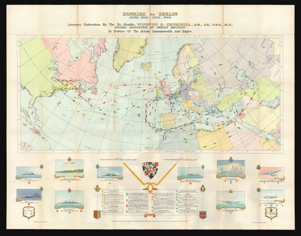
Colorful, numerically identified lines trace nineteen trips by air, sea, road, and rail to the United States, North Africa, continental Europe, the Middle East, and Russia. Colors represent different years: yellow for August 1941 through August 1942, green for August 1942 through August 1943, red for August 1943 through August 1944, and blue for August 1944 through August 1945. Among the more recognizable excursions are those to sign the Atlantic Charter, three trips Washington, D.C. for 'Washington Conferences', trips to the Cairo Conference, Teheran Conference, and the Yalta Conference, and visits to the Normandy Beachhead. Information concerning the trips appears in a legend situated at bottom center, with destinations, stops, and dates provided. Illustrations of warships and airplanes used to transport the Prime Minister encircle the legend and depict the Atlantic Charter meeting.Publication History and Census
This map was designed by Frank A. de Vine Hunt and originally published by George Philip and Sons and the London Geographical Institute. The present example was published in April 1956 for World Book members to 'commemorate the completion of publication of the Reprint Society edition of the Churchill War Memoirs'. We note eight examples cataloged in OCLC, at the Osher Map Library at the University of Southern Maine, the University of Virginia, the University of Toronto, the University of South Carolina, the University of Texas at Austin, the National Library of Australia, the State Library of Queensland, and the State Library of South Australia.
Cartographer
George Philip (1800 - 1882) was a map publisher and cartographer active in the in the mid to late-19th century. Philip was born into a Calvinst family in Huntly, Aberdeenshire, Scotland. Around 1819 he apprenticed himself to William Grapel, a Liverpool printer and bookseller. Fifteen years later, in 1834, Philip founded his own Liverpool book and map firm. Philip's earliest cartographic ventures were mostly educational material issued in tandem with John Bartholomew Sr., August Petermann and William Hughes. In 1848, Philip admitted his son, George Philip Jr. (1823 - 1902) into the firm, renaming it George Philip & Son Ltd. George Philip Jr. ran the firm until his death in 1902 by which time it had developed into a major publishing concern. His successors established the London Geographical Institute, a factory where they embraced modern printing techniques to produce thousands of economical and high quality maps. In April of 1988, George Philip & Son was acquired by Octopus Publishing, a branch of Reed International. Nonetheless, today the firm trades and publishes to this day as George Philip and Son. More by this mapmaker...
Very good. Light wear and toning along original fold lines. Else excellent with no mends and virtually no wear at folds. In original printed slipcase.
OCLC 968798106, 271691944.