This is a beautiful, original color example of Joan Blaeu's 1662 map of the Northern Dvina River in Russia: the conduit connecting Muscovy with global markets, via the port of Archangel.
A Closer Look
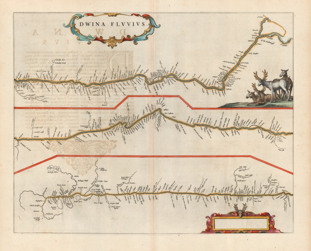
The course of the river is traced on this sheet in three separate panels. While no compass rose is provided, the orientation of each of the three panels is roughly westward, with the northern part of each stretch of the river appearing to the right. Each slightly overlaps with the others, making the continuity clear. The three maps taken together follow the course of the Dvina and the Sukhona Rivers through the Archangel and Vologda Oblasts.Russia's Artery to the Sea
The map describes the connection from the river's source in Vologda to Archangel, Russia's primary access to the sea prior to the foundation of St. Petersburg. The Northern Dvina River was an important waterway used for fur trading. Archangel would provide the conduit for virtually all sea trade to Russia during the 16th and 17th centuries. The Dutch first arrived in the North Sea near Archangel in the late 16th century, and this same route was employed by the English Muscovy Company. They monopolized the English-Russian trade until 1698, after which the Dutch returned as the dominant merchants. Even following the construction of St. Petersburg in the beginning of the 18th century, the Northern Dvina River remained a key trading route until the development of Russian railroads in the late 19th century. The Dvina River is today used mainly to transport timber.Decoratively Distinctive
A beautiful, oval strapwork title cartouche is included in the top left. In the lower right, an empty cartouche illustrated with a reindeer’s head appears. This may have been intended for the inclusion of scales, or the mapmaker's imprint. It would remain empty throughout the use of this plate by the Blaeu firm. Framed in the angle of the river of the top panel, a group of reindeer browse a grassy hummock.Publication History and Census
This map was engraved for inclusion in the Blaeu Atlas Maior, as early as 1659. It should be noted that the Jansson Dwinae Fluvii - probably issued shortly after Blaeu's map and presenting the same geographical information - was an entirely different plate. That work is sometimes seen in its later Moses Pitt reprint. The present Blaeu was reissued by Covens and Mortier, who added it to De Wit's Atlas Major following their acquisition of those plates from De Wit's widow, Maria. It is an open question whether Dwina Fluvius was among the plates acquired from De Wit, or the Blaeu firm on the final 1695 auction of their stock. De Wit had been employed by the Blaeu firm early in his career, and the absence of a mapmaker's imprint on this plate may indicate that the map was the work of an engraver other than Blaeu. We have seen no examples of this work bearing De Wit's imprint, and no examples appearing in a De Wit atlas prior to its acquisition by Covens and Mortier. The map is scarce, having been published only in the last editions of the Blaeu atlas. We see seven separate examples in OCLC.
Cartographer
Joan (Johannes) Blaeu (September 23, 1596 - December 21, 1673) was a Dutch cartographer active in the 17th century. Joan was the son of Willem Janszoon Blaeu, founder of the Blaeu firm. Like his father Willem, Johannes was born in Alkmaar, North Holland. He studied Law, attaining a doctorate, before moving to Amsterdam to join the family mapmaking business. In 1633, Willem arranged for Johannes to take over Hessel Gerritsz's position as the official chartmaker of the Dutch East India Company, although little is known of his work for that organization, which was by contract and oath secretive. What is known is his work supplying the fabulously wealthy VOC with charts was exceedingly profitable. Where other cartographers often fell into financial ruin, the Blaeu firm thrived. It was most likely those profits that allowed the firm to publish the Theatrum Orbis Terrarum, sive, Atlas Novus, their most significant and best-known publication. When Willem Blaeu died in 1638, Johannes, along with his brother Cornelius Blaeu (1616 - 1648) took over the management of the Blaeu firm. In 1662, Joan and Cornelius produced a vastly expanded and updated work, the Atlas Maior, whose handful of editions ranged from 9 to an astonishing 12 volumes. Under the brothers' capable management, the firm continued to prosper until the 1672 Great Amsterdam Fire destroyed their offices and most of their printing plates. Johannes Blaeu, witnessing the destruction of his life's work, died in despondence the following year. He is buried in the Dutch Reformist cemetery of Westerkerk. Johannes Blaeu was survived by his son, also Johannes but commonly called Joan II, who inherited the family's VOC contract, for whom he compiled maps until 1712. More by this mapmaker...
Source
Blaeu, J., Atlas Maior, (Amsterdam: Blaeu) 1662.
Excellent. Wide margins and rich original color. Some text showthrough, else fine.
OCLC: 165859824. Rumsey 10017.097. Van der Krogt, P. C. J., Koeman's Atlantes Neerlandici, (Vol=. 2), 1820.2, state 1.