This item has been sold, but you can get on the Waitlist to be notified if another example becomes available, or purchase a digital scan.
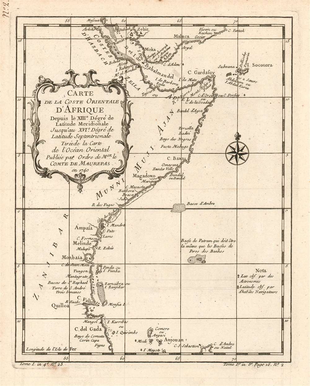
1780 Bellin Map of the Horn of Africa, Southern Arabia and the Gulf of Aden.
EastAfrica-bellin-1780$225.00

Title
Carte de la coste orientale d'Afrique depuis le XIIIe. Dégré de Latitude Meridionale Jusqu'au XVIe. Dégré de Latitude Septenrionale Tireé de la carte de l'ocean oriental publiée par ordre de mgr. le Comte de Maurepas en 1740.
1780 (undated) 9.75 x 7.75 in (24.765 x 19.685 cm) 1 : 14000000
1780 (undated) 9.75 x 7.75 in (24.765 x 19.685 cm) 1 : 14000000
Description
This is a 1780 Bellin map of the eastern coast of equatorial Africa and the southern coast of the Arabian Peninsula, starting at Cape Delgado in Mozambique and continuing to coastal Yemen. This little map is surprisingly well detailed. It names the Yemeni cities of Zabid (Zebit), Mocha (Moka), Aden, Al Mukalla, (Maluka on the map) Qusay'ir and Qishn (Gosier and Kisein or Kachen, respectively.) African place names include Quilloa (Kilwa) Mombasa, Mogadishu (Magadoxo), Bandarbeyla (Bandel 'Agoa on the map) and Āssab; Zanzibar is shown as well. The islands of Socotra, Comoros, Mayotte and the northernmost point of Madagascar also appear. The map includes notations indicating places whose latitudes had been observed by Astronomers, and those (much more numerous) having been observed by 'Skilled Navigators.' The map also shows areas of shallows, one named 'Basse (baixos) de Patram' which the cartographer notes 'must be the same as the Baixos de Pêro dos Banhos,' an atoll discovered by the Portuguese in 1513 noted for having had its avian population devastated by the arrival of some 165 castaways from the Portuguese ship Conceição in 1556.
Mapmakers are Admirable Recyclers
Bellin drew the information for this chart from his own superb 1740 chart of the Indian Ocean, Carte Reduite de l'Ocean Oriental ou Mer des Indes Contenant Les Costes d'Afrique. It was this grand chart, and not the present lovely if narrowly-focused engraving, that was produced 'Par Ordre' of the Count de Maurepas. It seems slightly misleading that Bellin should here invoke this famous French statesman, naval strategist and spymaster, given that the present map was to appear in Harpe's 1780 Abrégé de l'histoire générale des voyages, which epitomized Prévost's Histoire générale des voyages - a work perhaps better known for its imaginative flourish than for its factuality. This map is notable, however, for its focus on the indigenous African national names that appear on it.Publication History and Census
The map was included in Harpe's 1780 abridged edition of Prévost's Histoire générale des voyages. This map appears on the market from time to time, but OCLC lists only two copies of the separate map (at the Bayerische Staatsbibliothek and the Universitatbibliothek LMU Munchen) although inconsistencies in cataloguing mean this number may be higher. Prévost's Histoire and Harpe's abridged version of it are well represented in institutional collections.Cartographer
Jacques-Nicolas Bellin (1703 - March 21, 1772) was one of the most important cartographers of the 18th century. With a career spanning some 50 years, Bellin is best understood as geographe de cabinet and transitional mapmaker spanning the gap between 18th and early-19th century cartographic styles. His long career as Hydrographer and Ingénieur Hydrographe at the French Dépôt des cartes et plans de la Marine resulted in hundreds of high quality nautical charts of practically everywhere in the world. A true child of the Enlightenment Era, Bellin's work focuses on function and accuracy tending in the process to be less decorative than the earlier 17th and 18th century cartographic work. Unlike many of his contemporaries, Bellin was always careful to cite his references and his scholarly corpus consists of over 1400 articles on geography prepared for Diderot's Encyclopedie. Bellin, despite his extraordinary success, may not have enjoyed his work, which is described as "long, unpleasant, and hard." In addition to numerous maps and charts published during his lifetime, many of Bellin's maps were updated (or not) and published posthumously. He was succeeded as Ingénieur Hydrographe by his student, also a prolific and influential cartographer, Rigobert Bonne. More by this mapmaker...
Source
De la Harpe, Abrégé de l'histoire générale des voyages. (Paris) 1780.
Condition
Very good condition; minor stain just outside lower border. Else excellent with a bold strike and generous margins.
References
OCLC 163336665.