1770 Bonne Map of the East Indies (Java, Sumatra, Borneo, Singapore)
EastIndies2-bonne-1780$400.00

Title
Indes IVe. Feuille.
1770 (undated) 12 x 16.5 in (30.48 x 41.91 cm) 1 : 10000000
1770 (undated) 12 x 16.5 in (30.48 x 41.91 cm) 1 : 10000000
Description
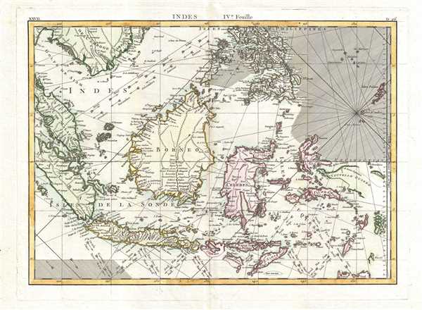
A beautiful example of Rigobert Bonne's 1771 decorative map the East Indies. Covers from the Gulf of Siam (Gulf of Thailand) and Malacca (Malaysia) eastward to include parts of Sumatra, Java, Borneo, the Celebes, parts of Cambodia, the southern Philippine Islands, and New Guinea. Offers considerable detail of the region. Notes the Straight of Singapore (Det. de Sin Capura) and shows but does not label the island of Singapore. In Borneo, this map provides good detail along the Banjermassin or Barito River, detailing numerous villages and trading stations. Names Bali and Lombok as well as Batavia. Several of the southern islands are drawn with their southern shores ghosted in - suggesting an uncertain coastline. This is also the case with much of New Guinea (Nouvelle Guinee), which was largely unexplored well into the 19th century. Rhumb lines throughout. Arrows in the lower right show the direction of prevailing winds during the dry season and the monsoon season. A fine map of the region. Drawn by R. Bonne in 1771 for issue as plate no. D 26 in Jean Lattre's 1776 issue of the Atlas Moderne.
CartographerS
Rigobert Bonne (October 6, 1727 - September 2, 1794) was one of the most important French cartographers of the late 18th century. Bonne was born in Ardennes à Raucourt, France. He taught himself mathematics and by eighteen was a working engineer. During the War of the Austrian Succession (1740 - 1748) he served as a military engineer at Berg-op-Zoom. It the subsequent years Bonne became one of the most respected masters of mathematics, physics, and geography in Paris. In 1773, Bonne succeeded Jacques-Nicolas Bellin as Royal Cartographer to France in the office of the Hydrographer at the Depôt de la Marine. Working in his official capacity, Bonne compiled some of the most detailed and accurate maps of the period - most on an equal-area projection known erroneously as the 'Bonne Projection.' Bonne's work represents an important step in the evolution of the cartographic ideology away from the decorative work of the 17th and early 18th century towards a more scientific and practical aesthetic. While mostly focusing on coastal regions, the work of Bonne is highly regarded for its detail, historical importance, and overall aesthetic appeal. Bonne died of edema in 1794, but his son Charles-Marie Rigobert Bonne continued to publish his work well after his death. More by this mapmaker...
Jean Lattré (170x - 178x) was a Paris based bookseller, engraver, globe maker, calligrapher, and map publisher active in the mid to late 18th century. Lattré published a large corpus of maps, globes, and atlases in conjunction with a number of other important French cartographic figures, including Janvier, Zannoni, Bonne and Delamarche. He is also known to have worked with other European cartographers such as William Faden of London and the Italian cartographer Santini. Map piracy and copyright violations were common in 18th century France. Paris court records indicate that Lattré brought charges against several other period map publishers, including fellow Frenchman Desnos and the Italian map engraver Zannoni, both of whom he accused of copying his work. Lattré likes trained his wife Madame Lattré (né Vérard), as an engraver, as a late 18th century trade card promotes the world of 'Lattré et son Epouse.' Lattré's offices and bookshop were located at 20 rue St. Jaques, Paris, France. Later in life he relocated to Bordeaux. Learn More...
Source
Lattre, Jean, Atlas Moderne ou Collection de Cartes sur Toutes les Parties du Globe Terrestre, c. 1775.
Condition
Very good condition. Original centerfold exhibits minor toning. Blank on verso.
References
Rumsey 2612.056. Phillips (Atlases) 664. National Maritime Museum, 215.