This item has been sold, but you can get on the Waitlist to be notified if another example becomes available, or purchase a digital scan.
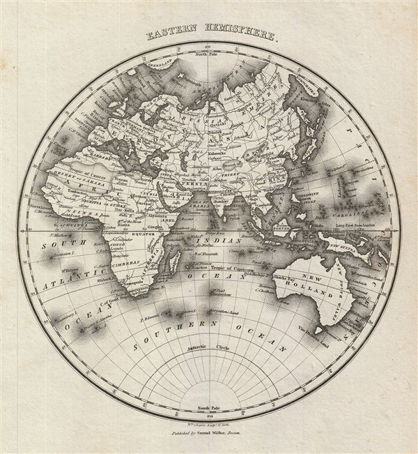
1828 Malte-Brun Map of the Eastern Hemisphere (Asia, Africa, Europe, Australia)
EasternHemisphere-maltebrun-1828$75.00

Title
Eastern Hemisphere.
1828 (undated) 9 x 8.5 in (22.86 x 21.59 cm)
1828 (undated) 9 x 8.5 in (22.86 x 21.59 cm)
Description
This is an attractive example of the 1828 Malte-Brun map of the eastern Hemisphere. It covers europe, Asia, Australia, Africa and the east Indies. Although 'New Holland' officially changed its name to Australia in 1824, it is here referred to by its older Dutch name. The interiors of Africa and Asia here follow archaic geographical conventions - giving evidnece to the general lack of knowledge about these regions in the early 19th century. The interior of Australia is entirely unexplored. The sea between Asia and Japan, whose name is a matter of political debate (either the 'Sea of Korea,' 'Sea of Japan') is here settled in favor of Korea. Various, important rivers, islands, cities and other topographical details are noted. This map was published by Samuel Walker in 1828 as part of the American edition of Conrad Malte-Brun's System of Geography, Vol. I.
Cartographer
Conrad Malte-Brun (August 12, 1755 - December 14, 1826) was an important late 18th and early 19th century Danish / French cartographer and revolutionary. Conrad was born in Thisted, Denmark. His parents encouraged him to a career in the Church, but he instead enrolled in the University of Copenhagen. In the liberal hall of academia Conrad became an ardent supporter of of the French Revolution and the ideals of a free press. Despite the harsh censorship laws of crown prince Frederick VI, Malte-Brun published numerous pamphlets criticizing the Danish government. He was finally charged with defying censorship laws in 1799 and forced to flee to Sweden and ultimately France. Along with colleague Edme Mentelle, Malte-Brun published his first cartographic work, the Géographie mathématique, physique et politique de toutes les parties du monde (6 vols., published between 1803 and 1807). Conrad went on to found Les Annales des Voyages (in 1807) and Les Annales des Voyages, de la Géographie et de l'Histoire (in 1819). He also founded the Paris Société de Géographie . In time, Conrad Malte-Brun became known as one of the finest French cartographers of his time. His son Victor Adolphe Malte-Brun (1816 - July 13, 1889) followed in his footsteps, republishing many of Conrad's original 18th century maps as well as producing numerous maps of his own. The Malte-Brun firm operated well into the 1880s. More by this mapmaker...
Source
Malte-Brun, M., System of Geography, Vol. I. (Boston; S. Walker), 1828.
Condition
Very good. Blank on verso.